Deer Lodge is an incorporated city in and the county seat of Powell County, Montana, in the United States. The population was 3,111 at the 2010 census. The city is perhaps best known as the home of the Montana State Prison, a major local employer. The Montana State Hospital in Warm Springs, and former state tuberculosis sanitarium in nearby Galen are the result of the power the western part of the state held over Montana at statehood due to the copper and mineral wealth in that area. Deer Lodge was also once an important railroad town, serving as a division headquarters for the Chicago, Milwaukee, St. Paul and Pacific Railroad before the railroad's local abandonment in 1980.

The Musselshell River is a tributary of the Missouri River, 341.9 miles (550.2 km) long from its origins at the confluence of its North and South Forks near Martinsdale, Montana to its mouth on the Missouri River. It is located east of the Continental divide entirely within Montana in the United States. Counting its pre-confluence tributaries, it measures 425–500 miles (684–805 km) in length.

The Clark Fork, or the Clark Fork of the Columbia River, is a river in the U.S. states of Montana and Idaho, approximately 310 miles (500 km) long. The largest river by volume in Montana, it drains an extensive region of the Rocky Mountains in western Montana and northern Idaho in the watershed of the Columbia River. The river flows northwest through a long valley at the base of the Cabinet Mountains and empties into Lake Pend Oreille in the Idaho Panhandle. The Pend Oreille River in Idaho, Washington, and British Columbia, Canada which drains the lake to the Columbia in Washington, is sometimes included as part of the Clark Fork, giving it a total length of 479 miles (771 km), with a drainage area of 25,820 square miles (66,900 km2). In its upper 20 miles (32 km) in Montana near Butte, it is known as Silver Bow Creek. Interstate 90 follows much of the upper course of the river from Butte to northwest of Missoula. The highest point within the river's watershed is Mount Evans at 10,641 feet (3,243 m) in Deer Lodge County, Montana along the Continental Divide.

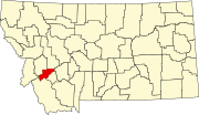
Anaconda, county seat of Deer Lodge County, which has a consolidated city-county government, is located in southwestern Montana of the United States. Located at the foot of the Anaconda Range, the Continental Divide passes within 8 mi (13 km) south of the community. As of the 2010 census the population of the consolidated city-county was 9,298, with a per capita personal income of $20,462 and a median household income of $34,716. It had earlier peaks of population in 1930 and 1980, based on the mining industry. It is still the ninth most populous city in Montana. Central Anaconda is 5,335 ft (1,626 m) above sea level, and is surrounded by the communities of Opportunity and West Valley.

The Bitterroot River is a northward flowing 84 miles (135 km) river running through the Bitterroot Valley, from the confluence of its West and East forks near Conner in southern Ravalli County to its confluence with the Clark Fork River near Missoula in Missoula County, in western Montana. The Clark Fork River is tributary to the Columbia River and ultimately, the Pacific Ocean. The Bitterroot River is a Blue Ribbon trout fishery with a healthy population of native westslope cutthroat trout and bull trout. It is the third most fly fished river in Montana behind the Madison and Big Horn Rivers.
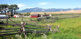
The Grant-Kohrs Ranch National Historic Site, created in 1972, commemorates the Western cattle industry from its 1850s inception through recent times. The original ranch was established in 1862 by a Canadian fur trader, Johnny Grant, at Cottonwood Creek, Montana, along the banks of the Clark Fork river. The ranch was later expanded by a cattle baron, Conrad Kohrs (1866–1920). The 1,618 acres (6.55 km2) historic site is maintained today as a working ranch by the National Park Service.

The Beaverhead-Deerlodge National Forest is the largest of the National Forests in Montana, United States. Covering 3.36 million acres (13,600 km2), the forest is broken into nine separate sections and stretches across eight counties in the southwestern area of the state. President Theodore Roosevelt named the two forests in 1908 and they were merged in 1996. Forest headquarters are located in Dillon, Montana. In Roosevelt's original legislation, the Deerlodge National Forest was called the Big Hole Forest Reserve. He created this reserve because the Anaconda Copper Mining Company, based in Butte, Montana, had begun to clearcut the upper Big Hole River watershed. The subsequent erosion, exacerbated by smoke pollution from the Anaconda smelter, was devastating the region. Ranchers and conservationists alike complained to Roosevelt, who made several trips to the area.
(Munday 2001)

The Anaconda-Pintler Wilderness is located in southwestern Montana, in the northwestern United States. It runs for 40 miles (65 km) along both sides of the crest of the Anaconda Range, covering almost 250 square miles (640 km2). To the north are the Sapphire Mountains, and to the south is the Big Hole Valley. Elevations range from about 5000 feet up to 10,793 feet at West Goat Peak. West Pintler Peak, located in a more commonly visited area, rises to 9894 feet. Visitors can most easily access this area via trailheads at Pintler Lake to the south, and at Lutz Creek and Moose Lake to the north. The wilderness lies in parts of Deer Lodge, Granite, Ravalli, and Beaverhead counties.

The Sapphire Mountains are a range of mountains located in southwestern Montana in the northwestern United States. From a point near the Clark Fork River and the city of Missoula, they run in a southerly direction for a distance of approximately 60 miles (100 km), making up much of the border between Ravalli County and Granite County. To the west is the Bitterroot Valley, and to the east is Rock Creek. The southern end of the range meets the larger Anaconda Range at West Pintler Peak.

The Anaconda Range, informally known as the "Pintlers", is a group of high mountains located in southwestern Montana, in the northwestern United States. The mountain range takes its name from the nearby town of Anaconda, founded by Marcus Daly in 1883. It runs northeast approximately 50 miles from Lost Trail Pass to a point near the community of Anaconda, covering parts of Ravalli, Deer Lodge, Granite and Beaverhead Counties. To the northwest are the Sapphire Mountains, to the south is the Big Hole Valley. Due north, the range blends into the Flint Creek Range, and to the southeast lies the Big Hole River and Pioneer Mountains. The crest of the range is part of the Continental Divide, rising to 10,793 feet at West Goat Peak. Other major summits include Mt. Evans, Mt. Haggin, Warren Peak, and East Goat Peak. West Pintler Peak, located in a more commonly visited area, rises to 9894 feet. Much of the range is protected in the Anaconda-Pintler Wilderness Area.

The Little Belt Mountains are a section of the Rocky Mountains in the U.S. state of Montana. Situated mainly in the Lewis and Clark National Forest, the mountains are used for logging and recreation for the residents of Great Falls, Montana. Showdown is a ski area located within the mountains located off US Highway 89 which splits the mountains in half connecting White Sulphur Springs and Belt, MT. The highest point in the Little Belt Range is Big Baldy Mountain at 9,175 feet (2,797 m).

The Flint Creek Range, el. 10,168 feet (3,099 m), is a mountain range northeast of Philipsburg, Montana in Granite County, Montana. The highest point in the range is Mount Powell, at 10,168 ft. in elevation.

Yogo sapphires are a variety of corundum found only in Yogo Gulch, part of the Little Belt Mountains in Judith Basin County, Montana, United States, on land once inhabited by the Piegan Blackfeet people. Yogos are typically cornflower blue, a result of trace amounts of iron and titanium. They have high uniform clarity and maintain their brilliance under artificial light. Because Yogo sapphires occur within a vertically dipping resistive igneous dike, mining efforts have been sporadic and rarely profitable. It is estimated that at least 28 million carats of Yogos are still in the ground. Jewelry containing Yogos was given to First Ladies Florence Harding and Bess Truman; in addition, many gems were sold in Europe, though promoters' claims that Yogos are in the crown jewels of England or the engagement ring of Princess Diana are dubious. Today, several Yogo sapphires are part of the Smithsonian Institution's gem collection.
Rock Creek is a 52-mile (84 km) river in Missoula and Granite County, Montana. Rock Creek is a tributary of the Clark Fork river. The river's headwaters are in Lolo National Forest near Phillipsburg, Montana. The river roughly parallels the Sapphire Mountains and enters the Clark Fork near Clinton, Montana. Sapphires are found along the river.

Granville Stuart was a pioneer, gold prospector, businessman, civic leader, vigilante, author, cattleman and diplomat who played a prominent role in the early history of Montana Territory and the state of Montana. Widely known as "Mr. Montana", Granville's life spanned the formative years of Montana from territorial times through the first 30 years of statehood. His journals and writings have provided Montana and western historians unique insights into life in the Northern Rockies during the second half the 19th Century.

Portneuf Wildlife Management Area at 3,104 acres (12.56 km2) is an Idaho Wildlife Management Area (WMA) in Bannock County near the town of McCammon. The first land acquisition for the WMA occurred in 1970 from M.S. Bastian, a local farmer and rancher. Three additional parcels were acquired in 1974.
Blacktail Deer Creek is a tributary of the Beaverhead River, approximately 38 miles (61 km) long, in southwest Montana in the United States.