
Grand Coulee Dam is a concrete gravity dam on the Columbia River in the U.S. state of Washington, built to produce hydroelectric power and provide irrigation water. Constructed between 1933 and 1942, Grand Coulee originally had two powerhouses. The third powerhouse ("Nat"), completed in 1974 to increase energy production, makes Grand Coulee the largest power station in the United States by nameplate capacity at 6,809 MW.

The Columbia Basin Project in Central Washington, United States, is the irrigation network that the Grand Coulee Dam makes possible. It is the largest water reclamation project in the United States, supplying irrigation water to over 670,000 acres (2,700 km2) of the 1,100,000 acres (4,500 km2) large project area, all of which was originally intended to be supplied and is still classified irrigable and open for the possible enlargement of the system. Water pumped from the Columbia River is carried over 331 miles (533 km) of main canals, stored in a number of reservoirs, then fed into 1,339 miles (2,155 km) of lateral irrigation canals, and out into 3,500 miles (5,600 km) of drains and wasteways. The Grand Coulee Dam, powerplant, and various other parts of the CBP are operated by the Bureau of Reclamation. There are three irrigation districts in the project area, which operate additional local facilities.

Grand Coulee is an ancient river bed in the U.S. state of Washington. This National Natural Landmark stretches for about 60 miles (100 km) southwest from Grand Coulee Dam to Soap Lake, being bisected by Dry Falls into the Upper and Lower Grand Coulee.

San Luis Dam, also known as B.F. Sisk Dam, is a major earth-filled dam in Merced County, California, which forms San Luis Reservoir, the largest off-stream reservoir in the United States. The dam and reservoir are located in the Diablo Range to the east of Pacheco Pass and about 10 miles (16 km) west of Los Banos. San Luis Dam, a jointly-owned state and federal facility, stores more than 2 million acre feet (2.5 km3) of water for the California State Water Project and the federal Central Valley Project. Although the dam is located in the valley of San Luis Creek, the majority of its water comes from man-made aqueducts which are supplied from other rivers in Northern California.

The Colorado–Big Thompson Project is a federal water diversion project in Colorado designed to collect West Slope mountain water from the headwaters of the Colorado River and divert it to Colorado's Front Range and plains. In Colorado, approximately 80% of the state's precipitation falls on the West Slope, in the Rocky Mountains, while around 80% of the state's growing population lives along the eastern slope, between the cities of Fort Collins and Pueblo.

The Klamath Project is a water-management project developed by the United States Bureau of Reclamation to supply farmers with irrigation water and farmland in the Klamath Basin. The project also supplies water to the Tule Lake National Wildlife Refuge, and the Lower Klamath National Wildlife Refuge. The project was one of the first to be developed by the Reclamation Service, which later became the Bureau of Reclamation.

The American Falls Dam is a concrete gravity-type dam in the western United States, located near American Falls, Idaho, on river mile 714.7 of the Snake River. The dam and reservoir are a part of the Minidoka Project on the Snake River Plain and are used primarily for flood control, irrigation, and recreation. When the original dam was built in the 1920s by the U.S. Bureau of Reclamation, the residents of American Falls were forced to relocate three-quarters of their town to make room for the reservoir.
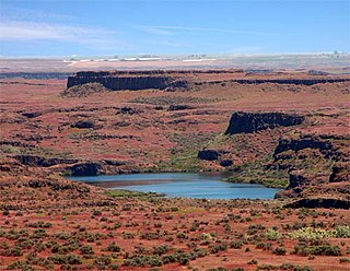
Drumheller Channels National Natural Landmark showcases the Drumheller Channels, which are the most significant example in the Columbia Plateau of basalt butte-and-basin Channeled Scablands. This National Natural Landmark is an extensively eroded landscape, located in south central Washington state characterized by hundreds of isolated, steep-sided hills (buttes) surrounded by a braided network of numerous channels, all but one of which are currently dry. It is a classic example of the tremendous erosive powers of extremely large floods such as those that reformed the Columbia Plateau volcanic terrain during the late Pleistocene glacial Missoula Floods.

Crab Creek is a stream in the U.S. state of Washington. Named for the presence of crayfish, it is one of the few perennial streams in the Columbia Basin of central Washington, flowing from the northeastern Columbia River Plateau, roughly 5 km (3.1 mi) east of Reardan, west-southwest to empty into the Columbia River near the small town of Beverly. Its course exhibits many examples of the erosive powers of extremely large glacial Missoula Floods of the late Pleistocene, which scoured the region. In addition, Crab Creek and its region have been transformed by the large-scale irrigation of the Bureau of Reclamation's Columbia Basin Project (CBP), which has raised water table levels, significantly extending the length of Crab Creek and created new lakes and streams.

Banks Lake is a 27-mile-long (43 km) reservoir in central Washington in the United States.

Jackson Lake Dam is a concrete and earth-fill dam in the western United States, at the outlet of Jackson Lake in northwestern Wyoming. The lake and dam are situated within Grand Teton National Park in Teton County. The Snake River emerges from the dam and flows about eight hundred miles (1,300 km) through Wyoming, Idaho, Oregon, and Washington to its mouth on the Columbia River in eastern Washington.
The Central Utah Project is a US federal water project that was authorized for construction under the Colorado River Storage Project Act of April 11, 1956, as a participating project. In general, the Central Utah Project develops a portion of Utah's share of the yield of the Colorado River, as set out in the Colorado River Compact of 1922.
The Quincy-Columbia Basin Irrigation District is a non-profit quasi-municipality located in North Central Washington state that operates and maintains a portion of the Columbia Basin Irrigation Project. The primary function of the Irrigation District is to deliver irrigation water to farm land located in the Columbia River Basin.

Agate Lake is a reservoir located 1,510 feet (460 m) above sea level in Jackson County, Oregon, United States. It is 13 miles (21 km) northeast of Medford, just north of Roxy Ann Peak. The lake is formed by the 86-foot (26 m) tall Agate Dam, which impounds Dry Creek, in the Rogue River watershed.

The Minidoka Project is a series of public works by the U.S. Bureau of Reclamation to control the flow of the Snake River in Wyoming and Idaho, supplying irrigation water to farmlands in Idaho. One of the oldest Bureau of Reclamation projects in the United States, the project involves a series of dams and canals intended to store, regulate and distribute the waters of the Snake, with electric power generation as a byproduct. The water irrigates more than a million acres (4,000 km²) of otherwise arid land, producing much of Idaho's potato crop. Other crops include alfalfa, fruit and sugar beets. The primary irrigation district lies between Ashton in eastern Idaho and Bliss in the southwestern corner of the state. Five main reservoirs collect water, distributing it through 1,600 miles (2,600 km) of canals and 4,000 miles (6,400 km) of lateral distribution ditches.

The San Juan–Chama Project is a U.S. Bureau of Reclamation interbasin water transfer project located in the states of New Mexico and Colorado in the United States. The project consists of a series of tunnels and diversions that take water from the drainage basin of the San Juan River – a tributary of the Colorado River – to supplement water resources in the Rio Grande watershed. The project furnishes water for irrigation and municipal water supply to cities along the Rio Grande including Albuquerque and Santa Fe.
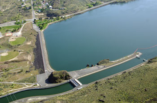
Pinto Dam is a dam in Grant County, Washington.
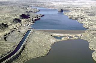
North Dam is an earth-fill embankment dam near the town of Grand Coulee in Grant County, Washington, United States. Construction of the dam began in 1946 and it was completed in 1951. Along with Dry Falls Dam about 22 mi (35 km) to the southeast, North Dam creates the reservoir Banks Lake within the ancient Grand Coulee riverbed. The lake serves as the equalizer reservoir of the Columbia Basin Project. Near the North Dam's left abutment is the entrance to the feeder canal of the project. The canal serves to either deliver water to the pump-generating plant at Grand Coulee Dam or return water to Banks Lake from the same pumped-storage plant.

Red Bluff Diversion Dam is a disused irrigation diversion dam on the Sacramento River in Tehama County, California, United States, southeast of the city of Red Bluff. Until 2013, the dam provided irrigation water for two canals that serve 150,000 acres (61,000 ha) of farmland on the west side of the Sacramento Valley. The dam and canals are part of the Sacramento Canals Unit of the Central Valley Project, operated by the U.S. Bureau of Reclamation. In 2013, the dam was decommissioned and the river allowed to flow freely through the site in order to protect migrating fish. A pumping plant constructed a short distance upstream now supplies water to the canal system.
The following outline is provided as an overview of and topical guide to infrastructure of the U.S. state of Washington.

