
The Wellington Region is a local-government region of New Zealand that occupies the southern end of the North Island. The region covers an area of 8,049 square kilometres (3,108 sq mi), and has a population of 542,000.
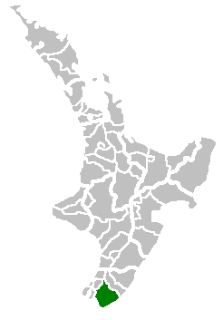
The South Wairarapa District is an area at the south-east tip of the North Island of New Zealand governed by the South Wairarapa District Council. The district comprises the southernmost part of the Wairarapa, and is part of the Wellington Region.
The Inangahua River is located in the northwest of New Zealand’s South Island. It is a major tributary of the Buller River, which it joins at the town of Inangahua Junction.

Palliser Bay is at the southern end of the North Island of New Zealand, to the southeast of Wellington. It runs for 40 kilometres along the Cook Strait coast from Turakirae Head at the southern end of the Rimutaka Ranges to Cape Palliser, the North Island's southernmost point.

The Ruamahanga River runs through the southeastern North Island of New Zealand.

Gladstone is a lightly populated locality in the Carterton District of New Zealand's North Island, located on the Mangahuia Stream near where the Tauweru River joins the Ruamahanga River. The nearest town is Carterton 15 kilometres to the northwest, and nearby settlements include Ponatahi to the west and Longbush to the south. It was named after British prime minister William Ewart Gladstone.
Ponatahi is a community in the South Wairarapa District of New Zealand's North Island. It is located near the Ruamahanga River south-southeast of Carterton and north east of Greytown. Nearby smaller settlements include Longbush to the south and Gladstone to the east.
The Tauweru River, sometimes called the Taueru River, is a river in the Wairarapa region of New Zealand's North Island. It drains from the pastoral eastern highlands of the Wairarapa and joins the Ruamahanga River just north of the Gladstone Road bridge into Gladstone, southeast of Carterton. The river's name is Māori for "hanging in clusters" and named after it is the town of Tauweru, located along the middle reaches of the river east of Masterton.
Tauweru, alternatively Taueru, and previously known as Wardell, or Wardelltown is a locality in the Wairarapa region of New Zealand's North Island. It is named after and located on the middle reaches of the Tauweru River, which drains into the Ruamahanga River near Gladstone and Te Whiti, and the name is a Māori-language word meaning "hanging in clusters".
The Eastern Hutt River is a river of New Zealand. It flows southwest from the Tararua Range to join with the Western Hutt River and become the Hutt River, a major river of the southern North Island.

The Flaxbourne River is a river in the Marlborough region of New Zealand. It arises in the Inland Kaikoura Range and Halden Hills and flows east and then south-east into the South Pacific Ocean near Ward. It is named after the Flaxbourne sheep station established by Sir Charles Clifford in 1847. The river is narrow and choked with willows.
The Kopuaranga River is a river of the Wairarapa, in New Zealand's North Island. It flows generally south from rough hill country southwest of Eketahuna, reaching its outflow into the Ruamahanga River 5 kilometres (3 mi) north of Masterton.
The Tauanui River is a river of the South Wairarapa District of the Wellington Region of New Zealand's North Island. It flows northwest from its source in the Aorangi Range to reach the Ruamahanga River close to the southern end of Lake Wairarapa.

The Waingawa River is a river of the Greater Wellington Region of New Zealand's North Island and a major tributary of the Ruamahanga River.

The Waiohine River is a river of the Greater Wellington Region of New Zealand's North Island.
The Makara River is a tributary of the Huangarua River, part of the Ruamahanga River system in New Zealand. It flows north from the Aorangi Range, reaching the Huangarua to the south of Martinborough.
The Turanganui River is a river in the Wellington Region of New Zealand. It flows through the south Wairarapa from its source in the Aorangi Range to reach the Ruamahanga River shortly before the latter's outflow into Palliser Bay.
Mangatarere Stream is a small gravel-bed stream in central Wairarapa, New Zealand, that originates in the Tararua Ranges. It is located close to the township of Carterton and is the main tributary to the Waiohine River. The Waiohine flows into the Ruamahanga River, southeast of Greytown.
State Highway 53 (SH 53) is a New Zealand state highway linking SH 2 at Featherston with Martinborough. The highway is a 17.8 km long two lane carriageway and forms part of the Classic New Zealand Wine Trail.
