
Cedar Rapids is the second-largest city in Iowa, United States and is the county seat of Linn County. The city lies on both banks of the Cedar River, 20 miles (32 km) north of Iowa City and 100 miles (160 km) northeast of Des Moines, the state's capital and largest city. It is a part of the Cedar Rapids/Iowa City region of Eastern Iowa, which includes Linn, Benton, Cedar, Iowa, Jones, Johnson, and Washington counties.

Dudley is a large market town and administrative centre in the county of West Midlands, England, 5.5 miles (8.9 km) south-east of Wolverhampton and 8 miles (13 km) north-west of Birmingham. Historically an exclave of Worcestershire, the town is the administrative centre of the Metropolitan Borough of Dudley and in 2011 had a population of 79,379. The Metropolitan Borough, which includes the towns of Stourbridge and Halesowen, had a population of 312,900. In 2014 the borough council named Dudley as the capital of the Black Country.
Dudley is a ghost town in Wapello County, Iowa, United States. Both 1908 and 1920 surveys of northwestern Wapello County show a post office at Dudley. A sign on the former edge of town reads: "Population 12 and God only knows how many dogs and cats."

The Des Moines River is a tributary of the Mississippi River in the upper Midwestern United States that is approximately 525 miles (845 km) long from its farther headwaters. The largest river flowing across the state of Iowa, it rises in southern Minnesota and flows across Iowa from northwest to southeast, passing from the glaciated plains into the unglaciated hills near the capital city of Des Moines, named after the river, in the center of the state. The river continues to flow at a southeastern direction away from Des Moines, later flowing directly into the Mississippi River.
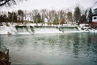
The Cedar River is a 338-mile-long (544 km) river in Minnesota and Iowa. It is a tributary of the Iowa River, which flows to the Mississippi River. The Cedar River takes its name from the red cedar trees growing there, and was originally called the Red Cedar River by the Meskwaki. The first Mississippi steamboat reached Cedar Rapids, Iowa in 1844, and during the next decade, the Red Cedar was an important commercial waterway. The surrounding region is known officially as the Cedar River Valley, though it is more commonly referred to simply as the Cedar Valley. The stream is young geologically, and only in places where the glacial material has been removed is the underlying bedrock exposed.
Dakota Dunes is an unincorporated community and census-designated place (CDP), master-planned residential and commercial development covering about 2,000 acres (8.1 km2) in Union County in the extreme southeast corner of the U.S. state of South Dakota. The population was 4,020 at the 2020 census.

Carter Lake is a shallow oxbow lake in Nebraska and Iowa, located next to Omaha and Carter Lake in the United States. Soon after its formation the lake was called the East Omaha Lake, and then Lake Nakoma.

The June 2008 Midwestern United States floods were flooding events which affected portions of the Midwestern United States. After months of heavy precipitation, a number of rivers overflowed their banks for several weeks at a time and broke through levees at numerous locations. Flooding continued into July. States affected by the flooding included Illinois, Indiana, Iowa, Michigan, Minnesota, Missouri and Wisconsin. The American Red Cross assisted the victims of flooding and tornadoes across seven states and the National Guard was mobilized to assist in disaster relief and evacuation.
Dorchester is an unincorporated community in northwestern Allamakee County, Iowa, United States. It lies along local roads just off Iowa Highway 76, north of the city of Waukon, the county seat of Allamakee County. Its elevation is 738 feet (225 m). The town was originally settled by Harvey Bell and Edmund Bell, and was named after Dorchester, England. Although Dorchester is unincorporated, it has a post office, with the ZIP code of 52140, which opened on 21 May 1857. Dorchester is located in Waterloo Township.

The Iowa flood of 2008 was a hydrological event involving most of the rivers in eastern Iowa which began June 8 and continued until July 1. Flooding continued on the Upper Mississippi River in the southeastern area of the state for many more days. The phrase "Iowa's Katrina" was often heard.
Preservation Iowa, formerly called the Iowa Historic Preservation Alliance (IHPA), was founded in 1989 by members of the public concerned about the destruction of significant historic sites and buildings in the state of Iowa.
Hopewell is an abandoned community in Mahaska County, Iowa, United States. The community was located in Monroe Township along the west bank of the North Skunk River. Hopewell had a post office from 1851 to 1877.
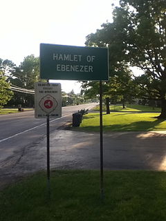
Ebenezer is a hamlet in the town of West Seneca in Erie County, New York, United States. It was established as part of the Ebenezer Colonies in 1842 by the Community of True Inspiration. After the community was annexed by the newly formed town of West Seneca in 1851, the Inspirationists moved on to the Amana Colonies in Iowa.

The environment of Iowa has been heavily affected by agricultural production since it became a U.S. state in 1846. However, there remain natural areas in Iowa that reflect a wide varieties of environmental niches.
The Great Flood of 1851 occurred after record-setting rainfalls across the Midwestern United States and Plains from May to August, 1851. Hardest hit was the State of Iowa, with significant flooding extending to the Lower Mississippi River basin. Historical evidence suggest flooding occurred in the eastern Plains, from Nebraska to the Red River basin, but these areas were sparsely settled in 1851. Heavy rainfall also occurred in the Ohio River basin.

Iowaville was a small town on the lowland near the northeast bank of the Des Moines River, near the line between Davis and Van Buren counties, and between present-day Eldon and Selma, Iowa. It was established about 1838 near the site of earlier trading posts. Iowaville is now farm land with almost nothing to show the town location, but it is an important Iowa archaeological site.
Jefferson Township is a township in Polk County, Iowa, United States.
Elkhart Township is a township in Polk County, Iowa, United States.
Dalby is an unincorporated community in Allamakee County, Iowa, United States.
Orleans is an unincorporated community in Appanoose County, Iowa, United States.
