Altoona, Iowa

Last updated

Altoona, Iowa
Polk County Iowa Incorporated and Unincorporated areas Altoona Highlighted.svg
Location within Polk County and Iowa
Altoona, Iowa
Interactive map of Altoona
Coordinates: 41°39′0″N93°28′21″W / 41.65000°N 93.47250°W / 41.65000; -93.47250
Country United States
State Iowa
County Polk
Area
[1]
  Total11.69 sq mi (30.28 km2)
  Land11.68 sq mi (30.25 km2)
  Water0.01 sq mi (0.03 km2)
Elevation
[2]
958 ft (292 m)
Population
 (2020)
  Total19,565
  Rank 26th in Iowa
  Density1,675.09/sq mi (646.76/km2)
Time zone UTC-6 (Central (CST))
  Summer (DST) UTC-5 (CDT)
ZIP code
50009
Area code 515
FIPS code 19-01630
GNIS feature ID2393939 [2]
Website altoona-iowa.com

Altoona is a city in Polk County, Iowa, United States, and part of the Des Moines metropolitan area. The population was 19,565 at the 2020 census. [3] It is home to the Adventureland amusement park and Prairie Meadows horse racing track and casino.

Contents

History

Anthony Yant first settled in what is now Altoona in 1854, the same year Gilbert T. Taylor settled there. The land was originally surveyed in 1847 and put up for sale by the US government in 1848, but it took six years to sell. After many sales between different families, the Davis family ended up with the land on February 1, 1868.[ citation needed ]

The Davises hired surveyor Julian B. Bausman to lay out the city. He is also credited for giving the city the current name. Altoona is named for the Latin word for "high," altus, after surveyor Julian B. Bausman discovered Altoona was the highest point on the Des Moines Valley Railroad between Des Moines and Keokuk. [4]

The plot was recorded on July 30, 1868, and the Post office opened the next day. When the Rock Island Railroad came to Altoona in September of that year, they referred to Altoona as Yant, the city's original name.[ citation needed ]

Altoona was incorporated as a city on March 11, 1876.[ citation needed ]

In addition to serving as Altoona's first mayor, Francis English was the town doctor. [5] After the great train crash of 1877, English was the first doctor on the scene.[ citation needed ]

Altoona's second mayor was Thomas Haines, who operated the T.E. Haines tile and brick company. Haines donated land to the city of Altoona to be used as a park, now known as Haines Park.[ citation needed ]

The only other mayor of Altoona to have a park dedicated to him is Sam Wise, noted for paving the streets of Altoona, and building a sewer system that was advanced for its time and allowed for future expansion. His dedication to Altoona's parks led to the city's sports complex being named the "Sam Wise Youth Complex."[ citation needed ]

By the turn of the 20th century, Altoona could almost be classified as a coal camp. United Mine Workers of America Local 407 was organized in Altoona in 1897, and by 1902, it had 61 members. This was close to 20 percent of the town's population at the time. [6]

On May 5, 2003, the Altoona City Council recognized the Altoona Area Historical Society as the city's official organization to collect, secure, and preserve the artifacts and records of the city of Altoona and surrounding areas. In 2011 the Altoona Area Historical Society started major renovation work on the interior of Altoona's oldest building. The building is now a museum.[ citation needed ]

In 2013, construction began for a new Facebook data center. Facebook asked local company RPM Access to build and operate a wind farm that will put more energy into the system than the data center will consume. [7]

In February 2016, the Cinemark Altoona theater opened.[ citation needed ]

Geography

According to the United States Census Bureau, the city has an area of 9.35 square miles (24.22 km2), all land. [8]

Demographics

Historical population
CensusPop.Note
1880 400
1890 326−18.5%
1900 3280.6%
1910 43833.5%
1920 50214.6%
1930 5142.4%
1940 64024.5%
1950 76319.2%
1960 1,45891.1%
1970 2,88397.7%
1980 5,76499.9%
1990 7,24225.6%
2000 10,34542.8%
2010 14,54140.6%
2020 19,56534.6%
Iowa Data Center
The population of Altoona, Iowa from US census data AltoonaIowaPopPlot.png
The population of Altoona, Iowa from US census data

2020 census

As of the census [9] [10] [11] of 2020, there were 19,565 people, 7,575 households, and 5,166 families residing in the city. The population density was 1,675.1 inhabitants per square mile (646.8/km2). There were 8,007 housing units. The racial makeup of the city was 86.5% White, 4.0% Black or African American, 0.3% Native American, 1.7% Asian, 0.2% Pacific Islander, 1.0% from other races, and 6.4% from two or more races. Hispanic or Latino of any race were 4.9% of the population.

There were 7,575 households, of which 34.2% had children under the age of 18 living with them, 52.9% were married couples living together, 24.9% had a female householder with no spouse or partner present, 15.5% had a male householder with no spouse or partner present, and 6.7% were cohabitating couples. 31.8% of all households were non-families. 25.6% of all households were made up of individuals, and 7.2% had someone living alone who was 65 years of age or older.

The median age in the city was 36.7 years. 28.2% of residents were under the age of 20; 5.8% were between the ages of 20 and 24; 27.4% were from 25 to 44; 24.1% were from 45 to 64; and 14.5% were 65 years of age or older. The gender makeup of the city was 48.6% male and 51.4% female.

2010 census

As of the census [12] of 2010, there were 14,541 people, 5,459 households, and 3,945 families residing in the city. The population density was 1,555.2 inhabitants per square mile (600.5/km2). There were 5,702 housing units at an average density of 609.8 per square mile (235.4/km2). The racial makeup of the city was 95.1% White, 1.1% African American, 0.1% Native American, 1.1% Asian, 0.2% Pacific Islander, 0.9% from other races, and 1.5% from two or more races. Hispanic or Latino of any race were 2.9% of the population.

There were 5,459 households, of which 42.2% had children under the age of 18 living with them, 57.1% were married couples living together, 11.6% had a female householder with no husband present, 3.6% had a male householder with no wife present, and 27.7% were non-families. 22.6% of all households were made up of individuals, and 6.6% had someone living alone who was 65 years of age or older. The average household size was 2.64 and the average family size was 3.12.

The median age in the city was 33.7 years. 30% of residents were under the age of 18; 7.4% were between the ages of 18 and 24; 30.4% were from 25 to 44; 23.1% were from 45 to 64; and 9.1% were 65 years of age or older. The gender makeup of the city was 48.9% male and 51.1% female.

2000 census

As of the census [13] of 2000, there were 10,345 people, 3,850 households, and 2,895 families residing in the city. The population density was 1,835.4 inhabitants per square mile (708.7/km2). There were 3,959 housing units at an average density of 557.3 per square mile (215.2/km2). The racial makeup of the city was 97.11% White, 0.92% African American, 0.33% Native American, 0.46% Asian, 0.41% Pacific Islander, 0.77% from other races, and 1.20% from two or more races. Hispanic or Latino of any race were 1.65% of the population.

There were 3,850 households, out of which 43.7% had children under the age of 18 living with them, 58.5% were married couples living together, 14.0% had a female householder with no husband present, and 24.8% were non-families. 19.9% of all households were made up of individuals, and 5.4% had someone living alone who was 65 years of age or older. The average household size was 2.66 and the average family size was 3.08.

Age spread: 30.6% under the age of 18, 8.1% from 18 to 24, 33.3% from 25 to 44, 20.3% from 45 to 64, and 7.7% who were 65 years of age or older. The median age was 32 years. For every 100 females, there were 91.4 males. For every 100 females age 18 and over, there were 85.9 males.

The median income for a household in the city was $50,162, and the median income for a family was $58,306. Males had a median income of $36,030 versus $28,205 for females. The per capita income for the city was $20,336. About 4.0% of families and 5.5% of the population were below the poverty line, including 7.2% of those under age 18 and 4.2% of those age 65 or over.

Education

Altoona (along with nearby Runnells, Mitchellville, and parts of Pleasant Hill and Des Moines) is part of the Southeast Polk Community School District, and its students attend Southeast Polk High School. The town is home to four of the district's eight elementary schools: Altoona, Centennial, Clay, and Willowbrook. The Altoona Elementary building also was the town's high school until it joined the Southeast Polk consolidation in 1962.

Transportation

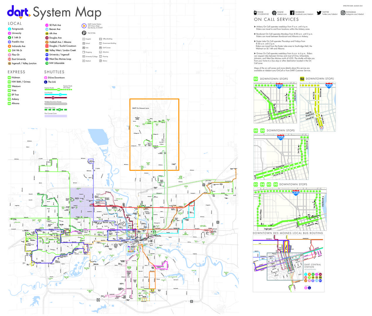
Transit in the city is provided by Des Moines Area Regional Transit. Routes 17 and 99 provide bus service connecting the city to the region. [14]

Notable people

Related Research Articles

<span class="mw-page-title-main">Polk County, Iowa</span> County in Iowa, United States

Polk County is located in the U.S. state of Iowa. As of the 2020 census, the population was 492,401. It is Iowa's most populous county, and home to over 15% of the state's residents. The county seat is Des Moines, which is also the capital city of Iowa. Polk County is included in the Des Moines–West Des Moines, IA Metropolitan Statistical Area.

<span class="mw-page-title-main">Sheldahl, Iowa</span> City in Iowa, United States

Sheldahl is a city in Polk, Boone, and Story counties in the U.S. state of Iowa. The population was 297 at the time of the 2020 census.

<span class="mw-page-title-main">Bouton, Iowa</span> City in Iowa, United States

Bouton is a city in Dallas County, Iowa, United States. The population was 127 at the 2020 census. It is part of the Des Moines–West Des Moines Metropolitan Statistical Area.

<span class="mw-page-title-main">Clive, Iowa</span> City in Iowa, United States

Clive is a city in Dallas and Polk counties in the U.S. state of Iowa. As of the 2020 Census, the population was 18,601. It is part of the Des Moines–West Des Moines Metropolitan Statistical Area. Clive is known for its Greenbelt Park and trail system running through the community. Clive serves as the axis of the western Des Moines suburbs, between Urbandale, Waukee and West Des Moines along the major transportation corridors of I-35, I-80 and I-235. The City of Urbandale is to the north to northwest, the City of West Des Moines is to the southeast to southwest, the City of Waukee in Dallas County is to the west.

<span class="mw-page-title-main">Dawson, Iowa</span> City in Iowa, United States

Dawson is a city in Dallas County, Iowa, United States. The population was 116 at the time of the 2020 census. It is part of the Des Moines–West Des Moines Metropolitan Statistical Area.

<span class="mw-page-title-main">De Soto, Iowa</span> City in Iowa, United States

De Soto is a city in Dallas County, Iowa, United States. The population was 915 at the time of the 2020 census. It is part of the Des Moines–West Des Moines Metropolitan Statistical Area.

<span class="mw-page-title-main">Granger, Iowa</span> City in Iowa, United States

Granger is a city in Dallas and Polk counties in the U.S. state of Iowa. The population was 1,654 at the time of the 2020 census, up 184% from 583 in 2000. It is part of the Des Moines–West Des Moines Metropolitan Statistical Area.

<span class="mw-page-title-main">Grimes, Iowa</span> City in Iowa, United States

Grimes is a city in Polk and Dallas counties in the U.S. state of Iowa. The population was 15,392 at the time of the 2020 Census. Grimes is part of the Des Moines-West Des Moines metropolitan area.

<span class="mw-page-title-main">Menlo, Iowa</span> City in Iowa, United States

Menlo is a city in Guthrie County, Iowa, United States. The population was 345 at the time of the 2020 census. It is part of the Des Moines–West Des Moines Metropolitan Statistical Area.

<span class="mw-page-title-main">Alleman, Iowa</span> City in Iowa, United States

Alleman is a city in Polk County, Iowa, United States. The population was 423 at the 2020 census. It is part of the Des Moines–West Des Moines Metropolitan Statistical Area.

<span class="mw-page-title-main">Bondurant, Iowa</span> City in Iowa, United States

Bondurant is a city in Polk County, Iowa, United States. The population was 7,365 in the 2020 census, an increase of 90.8% from the 3,860 population in 2010. It is part of the Des Moines–West Des Moines metropolitan statistical area.

<span class="mw-page-title-main">Elkhart, Iowa</span> City in Iowa, United States

Elkhart is a city in Polk County, Iowa, United States. The population was 882 at the time of the 2020 census. It is part of the Des Moines–West Des Moines Metropolitan Statistical Area.

<span class="mw-page-title-main">Johnston, Iowa</span> City in Iowa, United States

Johnston is a city in Polk County, Iowa, United States. The population was 24,064 in the 2020 census, a large increase from the 8,649 population in 2000. It is part of the Des Moines–West Des Moines Metropolitan Statistical Area.

<span class="mw-page-title-main">Pleasant Hill, Iowa</span> City in Iowa, United States

Pleasant Hill is a city in Polk County, Iowa, United States. The population was 10,147 at the time of the 2020 census. It is part of the Des Moines metropolitan area. As of July 2005, Pleasant Hill was assigned a ZIP code, 50327.

<span class="mw-page-title-main">Polk City, Iowa</span> City in Iowa, United States

Polk City is a city in Polk County, Iowa, United States. The population was 5543 in the 2020 census, an increase from 2,344 in 2000. It is part of the Des Moines–West Des Moines Metropolitan Statistical Area.

<span class="mw-page-title-main">Runnells, Iowa</span> City in Iowa, United States

Runnells is a city in the southeastern corner of Polk County, Iowa, United States. The population was 457 at the time of the 2020 census. It is part of the Des Moines–West Des Moines Metropolitan Statistical Area. Runnells has its own Post Office, located at 112 Brown Street.

<span class="mw-page-title-main">Windsor Heights, Iowa</span> City in Iowa, United States

Windsor Heights is a city in Polk County, Iowa, United States. The population was 5,252 at the time of the 2020 census. It is part of the Des Moines–West Des Moines Metropolitan Statistical Area.

<span class="mw-page-title-main">Martensdale, Iowa</span> City in Iowa, United States

Martensdale is a city in Warren County, Iowa, United States. The population was 421 at the time of the 2020 census. It is part of the Des Moines–West Des Moines Metropolitan Statistical Area

<span class="mw-page-title-main">Mitchellville, Iowa</span> City in Iowa, United States

Mitchellville is a city located in Polk and Jasper counties in the U.S. state of Iowa. The population was 2,485 at the time of the 2020 census.

<span class="mw-page-title-main">Carlisle, Iowa</span> City in Iowa, United States

Carlisle is a city in Warren and Polk counties in the U.S. state of Iowa. The population was 4,160 at the 2020 census. The city is part of the Des Moines–West Des Moines Metropolitan Statistical Area.

References

  1. "2020 U.S. Gazetteer Files". United States Census Bureau. Retrieved March 16, 2022.
  2. 1 2 U.S. Geological Survey Geographic Names Information System: Altoona, Iowa
  3. "2020 Census State Redistricting Data". census.gov. United states Census Bureau. Retrieved August 12, 2021.
  4. Henning, Barbara Beving Long; Patrice K. Beam (2003). Des Moines and Polk County: Flag on the Prairie. Sun Valley, California: American Historical Press. ISBN   1-892724-34-0.
  5. Payne, Alex (2018). Rising to New Heights: 150 Years of Altoona History. Brookfield, Missouri: Donning Company Publishers. ISBN   978-1-68184-191-5.
  6. Trade Unions in Iowa – Table No. 1, Mine Workers of America, United, Tenth Biennial Report of the Bureau of Labor Statistics for the State of Iowa, 1901–1902, Murphy, Des Moines, 1903; page 232.
  7. Coldewey, Devin. "www.nbcnews.com/technology/wind-farm-meets-server-farm-latest-facebook-data-center-2D11591372". NBC News. Retrieved November 14, 2013.
  8. "US Gazetteer files 2010". United States Census Bureau. Archived from the original on January 12, 2012. Retrieved May 11, 2012.
  9. "U.S. Census QuickFacts". United States Census Bureau . Retrieved July 30, 2023.
  10. "2020 Census Demographic Profile". United States Census Bureau . Retrieved July 30, 2023.
  11. "2020 Census Demographic Profile". United States Census Bureau . Retrieved July 30, 2023.
  12. "U.S. Census website". United States Census Bureau . Retrieved May 11, 2012.
  13. "U.S. Census website". United States Census Bureau . Retrieved January 31, 2008.
  14. "DART System Map" . Retrieved August 28, 2023.