Related Research Articles

Boonah is a rural town and locality in the Scenic Rim Region, Queensland, Australia. In the 2016 census the locality of Boonah had a population of 2,484 people.

Mount Lindesay is a rural locality in the Scenic Rim Region, Queensland, Australia. It borders New South Wales. In the 2016 census, Mount Lindesay had a population of 3 people.

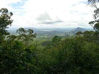
The Scenic Rim is a group of forested mountain ranges of the Great Dividing Range, located south of Brisbane agglomeration, straddling the border between south-eastern Queensland and north-eastern New South Wales, Australia. In 2021, the Scenic Rim was named as a Lonely Planet top destination for 2022.
Fassifern Valley is a valley of the Scenic Rim in South East Queensland. Towns found in the valley include Harrisville, Kalbar, Roadvale, Warril View and Aratula. Fassifern Valley is known as a carrot-producing area, as well as for growing potatoes, onions, pumpkins and melons. It is one of four vegetable-producing regions in southern Queensland, the others being the Lockyer Valley, the eastern Darling Downs and the Granite Belt.

The Dugandan railway line was a branch railway in the Scenic Rim region of South East Queensland, Australia. It was also known as the Fassifern railway line. It operated from 1882 to 1964.

Dugandan is a rural town and locality in the Scenic Rim Region, Queensland, Australia. In the 2016 census, Dugandan had a population of 593 people.

Maroon is a rural locality in the Scenic Rim Region, Queensland, Australia. In the 2016 census, Maroon had a population of 149 people.

Barney View is a rural locality in the Scenic Rim Region, Queensland, Australia. In the 2016 census, Barney View had a population of 64 people.

Running Creek is a rural locality in the Scenic Rim Region, Queensland, Australia. In the 2016 census Running Creek had a population of 147 people. It borders New South Wales.

Lamington is a rural locality in the Scenic Rim Region, Queensland, Australia. In the 2016 census Lamington had a population of 86 people.

Mount French is a rural locality in the Scenic Rim Region, Queensland, Australia. In the 2016 census, Mount French had a population of 94 people.

Carneys Creek is a rural locality in the Scenic Rim Region, Queensland, Australia. In the 2016 census Carneys Creek had a population of 51 people. It borders New South Wales.

Moogerah is a rural locality in the Scenic Rim Region, Queensland, Australia. In the 2016 census, Moogerah had a population of 234 people.

Tarome is a rural locality in the Scenic Rim Region, Queensland, Australia. In the 2016 census, Tarome had a population of 118 people.
Croftby is a rural locality in the Scenic Rim Region, Queensland, Australia. In the 2016 census, Croftby had a population of 133 people. The town of Teviot is within the locality.

Clumber is a rural locality in the Scenic Rim Region, Queensland, Australia. In the 2016 census, Clumber had a population of 60 people.

Moorang is a rural locality in the Scenic Rim Region, Queensland, Australia. In the 2016 census, Moorang had a population of 46 people.
Burnett Creek is a rural locality in the Scenic Rim Region, Queensland, Australia. In the 2016 census Burnett Creek had a population of 11 people. It borders New South Wales to the south.

Cainbable is a rural locality in the Scenic Rim Region, Queensland, Australia. In the 2016 census Cainbable had a population of 74 people.
Morwincha is a rural locality in the Scenic Rim Region, Queensland, Australia. In the 2016 census, Morwincha had a population of 30 people.
References
- ↑ "Dugandan Range – mountain range in the Scenic Rim Region (entry 10753)". Queensland Place Names. Queensland Government . Retrieved 14 January 2022.
- 1 2 "Mountain ranges beaches and sea passages - Queensland". Queensland Open Data. Queensland Government. 12 November 2020. Archived from the original on 25 November 2020. Retrieved 25 November 2020.