Related Research Articles
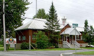
North Stormont is a lower tier township in eastern Ontario, Canada in the United Counties of Stormont, Dundas and Glengarry.

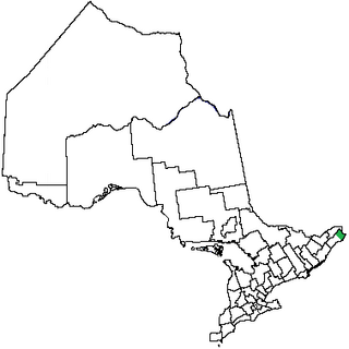
The United Counties of Stormont, Dundas and Glengarry (SDG) is an upper-tier municipality in the Canadian province of Ontario that comprises three historical counties and excludes the City of Cornwall and the Mohawk Nation of Akwesasne. However, both Cornwall and Akwesasne form part of a larger census division named for the United Counties of Stormont, Dundas and Glengarry. The municipality's administrative office is located within Cornwall.
Stormont County area 248,608 acres (1,006 km2) is a county in the Canadian province of Ontario.
Glengarry County, an area covering 288,688 acres (1,168 km2), is a former county in the province of Ontario, Canada. It is historically known for its settlement of Scottish Highlanders. Glengarry County now consists of the modern-day townships of North Glengarry and South Glengarry and it borders the Saint Lawrence River.
Durham County is an historic county in Ontario, Canada. It was named for the English County Durham and city of Durham. It was created in 1792 but was later merged Northumberland County to form the United Counties of Northumberland and Durham. In 1974, the two counties were split and reorganized, with the former portions of Durham County reorganized into the Regional Municipality of Durham.

Eastern District was one of four districts of the Province of Quebec created in 1788 in the western reaches of the Montreal District and partitioned in 1791 to create the new colony of Upper Canada.
South Dundas is a municipality in eastern Ontario, Canada, in the United Counties of Stormont, Dundas and Glengarry along the north shore of the St. Lawrence River. It is located approximately 100 kilometres south of Ottawa and is midway between Kingston and Montreal, Quebec.

Stormont, Dundas and Glengarry Highlanders is a Primary Reserve infantry regiment of the Canadian Army. It is part of 33 Canadian Brigade Group, 4th Canadian Division and is headquartered in Cornwall, Ontario.
The Long Sault Parkway is a group of eleven islands west of Cornwall in the Canadian province of Ontario, as well as the name of the 10.1-kilometre (6.3 mi) scenic parkway connecting them. The islands, which include two public beaches and three campgrounds, were created by the flooding of the Long Sault rapids during construction of the St. Lawrence Seaway. The parkway, the islands, and their amenities are maintained by the St. Lawrence Parks Commission.
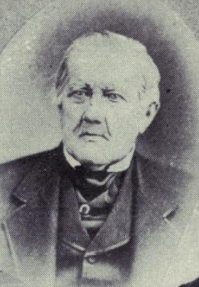
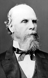
John Pliny Crysler was a timber merchant and political figure in Canada West.
John Sylvester Ross was a miller and political figure in Ontario. He was a Liberal-Conservative member of the House of Commons of Canada who represented Dundas from 1867 to 1872 and from 1879 to 1882.
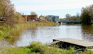
Chesterville is a village in the township of North Dundas, within the United Counties of Stormont, Dundas and Glengarry. It is located north of Morrisburg, west of Cornwall and south-east of Ottawa. The village is situated along the South Nation River.
The Stormont, Dundas and Glengarry County Library, Ontario, Canada, was established in 1971, the SD&G County Library grew from the merger of seven existing libraries located in a number of small rural communities of Eastern Ontario, Canada: Lancaster, Ingleside, Newington, Morrisburg, Chesterville, Winchester and South Mountain. Added in the same year were branches in Maxville and Alexandria, followed by Long Sault (1972); Crysler (1973); Moose Creek, Avonmore, St. Andrews, Williamstown (1975); Brinston (1976–1998); Finch (1978) and Dalkeith (1978-2016); Williamsburg (1979); Morewood (1986-2016); Glen Robertson (1988–1998); Lancaster Township (1992–2001); and Iroquois (1998).
Morrisburg is an unincorporated community in the Municipality of South Dundas, located in Eastern Ontario, Canada.
Dundas was an electoral district of the Legislative Assembly of the Parliament of the Province of Canada, in Canada West, on the north shore of the Saint Lawrence River east of Lake Ontario. It was created in 1841, upon the establishment of the Province of Canada by the union of Upper Canada and Lower Canada.
Glengarry was an electoral district of the Legislative Assembly of the Parliament of the Province of Canada, in Canada West, on the north shore of the Saint Lawrence River, bordering on Canada East. It was created in 1841, upon the establishment of the Province of Canada by the union of Upper Canada and Lower Canada. Glengarry was represented by one member in the Legislative Assembly. It was abolished in 1867, upon the creation of Canada and the province of Ontario.
Grenville was an electoral district of the Legislative Assembly of the Parliament of the Province of Canada, in Canada West. Based on Grenville County, it was located on the north shore of the Saint Lawrence River, east of Lake Ontario. It was created in 1841, upon the establishment of the Province of Canada by the union of Upper Canada and Lower Canada. Grenville was represented by one member in the Legislative Assembly. It was later split into two ridings, in a redistribution.
Stormont was an electoral district of the Legislative Assembly of the Parliament of the Province of Canada, in Canada West. It was created in 1841, upon the establishment of the Province of Canada by the union of Upper Canada and Lower Canada. Stormont was represented by one member in the Legislative Assembly. It was abolished in 1867, upon the creation of Canada and the province of Ontario.
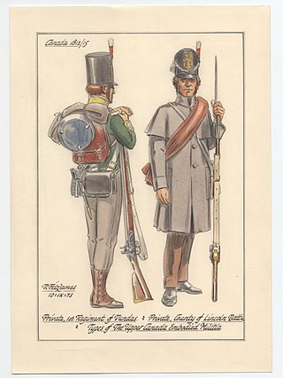
The Dundas County Militia was a regiment of the provincial militia of Upper Canada that was raised in Dundas County, Ontario, in the 1780s. The battle honours and legacy of the Dundas Militia are perpetuated by the Stormont, Dundas and Glengarry Highlanders.
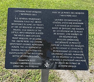
The Battle of Point Iroquois was a small skirmish fought on the morning of November 8, 1813, as part of Wilkinson's advance up the St. Lawrence towards Montreal. The skirmish occurred on the shores of the St. Lawrence River at Point Iroquois, Dundas County, where the river reached its narrowest point.
References
- ↑ Proclamation, Lieutenant Governor John Graves Simcoe, July 16, 1792; reprinted in Statutes of the Province of Upper Canada; Together with Such British Statutes, Ordinances of Quebec, and Proclamations, as Relate to the Said Province (Kingston: F. M. Hill., 1831) p. 24.
- ↑ An act for the better division of this province, SUC 1798, c. 5, s. 3. Reprinted in The Statutes of Upper Canada to the Time of Union, Revised and Published by Authority, Vol. I - Public Acts (Toronto: Robert Stanton, Queen's Printer, 1843).
- ↑ Canada (1848). "The Provincial Statutes of Canada".