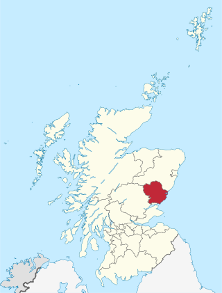
Angus is one of the 32 local government council areas of Scotland, a registration county and a lieutenancy area. The council area borders Aberdeenshire, Dundee City and Perth and Kinross. Main industries include agriculture and fishing. Global pharmaceuticals company GSK has a significant presence in Montrose in the east of the county.

Dundee is the fourth-largest of the eight cities of Scotland. The mid-year population estimate for 2016 was 148,210, giving Dundee a population density of 2,478/km2 or 6,420/sq mi, the second-highest in Scotland. It lies within the eastern central Lowlands on the north bank of the Firth of Tay, which feeds into the North Sea. Under the name of Dundee City, it forms one of the 32 council areas used for local government in Scotland.

Tipton County is a county in the U.S. state of Indiana, located north of the state capital of Indianapolis. According to the 2020 census, it had a population of 15,359. Its county seat is Tipton. The county has four incorporated towns with a total population of about 7,000, as well as many small unincorporated communities. It is divided into six townships which provide local services. Three Indiana state roads and one U.S. Route cross the county, as do two railroad lines. Before the arrival of non-indigenous settlers in the early 19th century, the area was inhabited by several Native American tribes. The county was officially established in 1844, one of the last Indiana counties to be settled. Tipton and Howard Counties were established by the same legislative action on January 15.

Madison County is a county in the U.S. state of Indiana. The 2020 census states the population is standing at 130,129. The county seat since 1836 has been Anderson, one of three incorporated cities within the county.

Jefferson County is a county located in the U.S. state of Indiana. As of 2020, the population was 33,147. The county seat is Madison.

Hancock County is a county in the U.S. state of Indiana. The 2020 United States Census recorded a population of 79,840. The county seat is Greenfield.

Corydon is a town in Harrison Township, Harrison County, Indiana. Located north of the Ohio River in the extreme southern part of the U.S. state of Indiana, it is the seat of government for Harrison County. Corydon was founded in 1808 and served as the capital of the Indiana Territory from 1813 to 1816. It was the site of Indiana's first constitutional convention, which was held June 10–29, 1816. Forty-three delegates convened to consider statehood for Indiana and drafted its first state constitution. Under Article XI, Section 11, of the Indiana 1816 constitution, Corydon was designated as the capital of the state, which it remained until 1825, when the seat of state government was moved to Indianapolis. In 1863, during the American Civil War, Corydon was the site of the Battle of Corydon, the only official pitched battle waged in Indiana during the war. More recently, the town's numerous historic sites have helped it become a tourist destination. A portion of its downtown area is listed in the National Register of Historic Places as the Corydon Historic District. As of the 2010 census, Corydon had a population of 3,122.

Dundee United Football Club is a Scottish professional football club based in the city of Dundee. Formed in 1909, originally as Dundee Hibernian, the club changed to the present name in 1923. United are nicknamed The Terrors or The Tangerines and the supporters are known as Arabs.

The Indiana Territory, officially the Territory of Indiana, was created by an organic act that President John Adams signed into law on May 7, 1800, to form an organized incorporated territory of the United States that existed from July 4, 1800, to December 11, 1816, when the remaining southeastern portion of the territory was admitted to the Union as the state of Indiana. The territory originally contained approximately 259,824 square miles (672,940 km2) of land, but its size was decreased when it was subdivided to create the Michigan Territory (1805) and the Illinois Territory (1809). The Indiana Territory was the first new territory created from lands of the Northwest Territory, which had been organized under the terms of the Northwest Ordinance of 1787. The territorial capital was the settlement around the old French fort of Vincennes on the Wabash River, until transferred to Corydon near the Ohio River in 1813.

William Conner was an American trader, interpreter, military scout, community leader, entrepreneur, and politician. Although Conner initially established himself as a fur trader on the Michigan and Indiana frontiers, his business interests later expanded to include ownership of Indiana farms, mills, distilleries, and mercantile shops. He was also a land speculator. Conner served the American forces in several capacities during the War of 1812, and as an interpreter and witness at several treaty negotiations with Native American tribes that resulted their removal from Indiana and established the state's geographical boundaries.
Events from the year 1889 in the United Kingdom.

Pipe Creek Township is one of fourteen townships in Madison County, Indiana, United States. As of the 2010 census, its population was 12,497 and it contained 5,828 housing units.
Fishersburg is an unincorporated community and census-designated place (CDP) in Stony Creek Township, Madison County, Indiana, United States.

Roll is an unincorporated community in Washington Township, Blackford County, in the U.S. state of Indiana. Nearly all of the community's businesses have been closed for years. Although the Blackford County Historical Society lists Roll as a ghost town, homes are still maintained in the area, and it is still listed as a populated place by the U.S. Geological Survey. The rural community is located on Indiana State Road 18, about one mile west of its intersection with Indiana State Road 3.
Florida is an unincorporated community in Lafayette Township, Madison County, Indiana.

Indiana is a U.S. state in the Midwestern United States. It is the 38th-largest by area and the 17th-most populous of the 50 States. Its capital and largest city is Indianapolis. Indiana was admitted to the United States as the 19th state on December 11, 1816. It is bordered by Lake Michigan to the northwest, Michigan to the north and northeast, Ohio to the east, the Ohio River and Kentucky to the south and southeast, and the Wabash River and Illinois to the west.
The 2011–12 season was Dundee's seventh consecutive season in the Scottish First Division, having been relegated from the Scottish Premier League at the end of the 2004–05 season. Dundee also competed in the Challenge Cup, League Cup and the Scottish Cup. Dundee was promoted to the Scottish Premier League at the end of the campaign after Rangers' liquidation meant a 2nd-place finish was enough to be promoted.
The 2012–13 season was the club's 104th season, having been founded as Dundee Hibernian in 1909 and their 15th consecutive season in the Scottish Premier League, having competed in it since its inauguration in 1998–99. United also competed in the Europa League, League Cup and the Scottish Cup.
The 2022–23 Scottish Premiership was the tenth season of the Scottish Premiership, the highest division of Scottish football, and the 126th edition overall of the top national league competition, not including one cancelled due to World War II. The season began on 30 July 2022.


