
Gary is a city in Lake County, Indiana, United States. The city has been historically dominated by major industrial activity and is home to U.S. Steel's Gary Works, the largest steel mill complex in North America. Gary is located along the southern shore of Lake Michigan about 25 miles (40 km) southeast of downtown Chicago, Illinois. The city is adjacent to the Indiana Dunes National Park, and is within the Chicago metropolitan area.
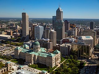
Indianapolis, colloquially known as Indy, is the capital and most populous city of the U.S. state of Indiana and the seat of Marion County. Located in Central Indiana, the city lies along the White River's West Fork near its confluence with Fall Creek.

Vermillion County lies in the western part of the U.S. state of Indiana between the Illinois border and the Wabash River. As of the 2020 census, the population was 15,439. The county seat is Newport. It was officially established in 1824 and was the fiftieth Indiana county created. Vermillion County is included in the Terre Haute, Indiana, Metropolitan Statistical Area. The county contains seven incorporated towns with a total population of about 9,900. as well as several unincorporated communities; it is also divided into five townships which provide local services. An interstate highway, two U.S. routes, and five state roads cross the county, as does a major railroad line.

Madison County is a county in the U.S. state of Indiana. The 2020 census states the population is standing at 130,129. The county seat since 1836 has been Anderson, one of three incorporated cities within the county.
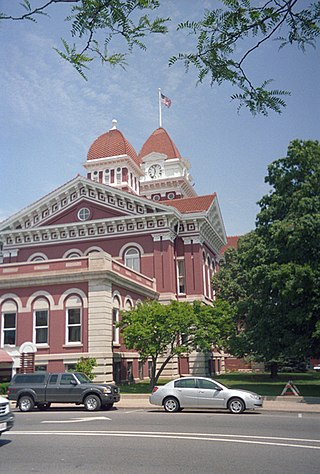
Lake County is a county located in the U.S. state of Indiana. In 2020, its population was 498,700, making it Indiana's second-most populous county. The county seat is Crown Point. The county is part of Northwest Indiana and the Chicago metropolitan area, and contains a mix of urban, suburban and rural areas. It is bordered on the north by Lake Michigan and contains a portion of the Indiana Dunes. It includes Marktown, Clayton Mark's planned worker community in East Chicago.

Hamilton County is a county in the U.S. state of Indiana. The 2020 United States Census recorded a population of 347,467. The county seat is Noblesville.
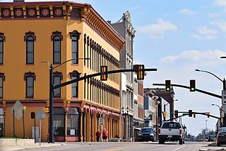
Muncie is an incorporated city and the seat of Delaware County, Indiana, United States. Previously known as Buckongahelas Town, named after the legendary Delaware Chief, it is located in East Central Indiana, about 50 miles (80 km) northeast of Indianapolis. At the 2020 United States Census, the city's population was 65,195, down from 70,085 in the 2010 Census. It is the principal city of the Muncie Metropolitan Statistical Area, which encompasses all of Delaware County. The city is also included in the Indianapolis–Carmel–Muncie, IN Combined Statistical Area.

Farmingdale is an incorporated village on Long Island within the Town of Oyster Bay in Nassau County, New York, United States. The population was 8,466 at the time of the 2020 Census.

Indiana is a borough in and the county seat of Indiana County, Pennsylvania, United States. The population was 14,044 at the 2020 census. It is the principal city of the Indiana, Pennsylvania micropolitan area, about 46 miles (74 km) northeast of Pittsburgh. It is a part of the greater Pittsburgh–New Castle–Weirton combined statistical area, as well as the Johnstown and Pittsburgh media markets.

Red Hook is a village in Dutchess County, New York, United States. The population was 1,961 at the 2010 census. It is part of the Poughkeepsie–Newburgh–Middletown, NY Metropolitan Statistical Area as well as the larger New York–Newark–Bridgeport, NY-NJ-CT-PA Combined Statistical Area. The name is derived from the Dutch "Roode Hoeck" – hoeck meaning peninsula, and roode meaning red – a reference to the vibrant reds in the area's fall foliage.

Indiana's 4th congressional district is a congressional district in the U.S. state of Indiana. From 2003 to 2013 the district was based primarily in the central part of the state, and consisted of all of Boone, Clinton, Hendricks, Morgan, Lawrence, Montgomery, and Tippecanoe counties and parts of Fountain, Johnson, Marion, Monroe, and White counties. The district surrounded Indianapolis including the suburban area of Greenwood and encompassed the more exurban areas of Crawfordsville and Bedford, as well as the college town of Lafayette-West Lafayette, containing Purdue University.
Howe is an unincorporated community and census-designated place in Lima Township, LaGrange County, Indiana. As of the 2010 census its population was 807.

Northern Indiana is a region of the U.S. State of Indiana, including 26 counties which border the states of Illinois, Michigan, and Ohio. Northern Indiana is also considered part of the Great Lakes Megalopolis. The area is generally classified into other sub-regions; Northwest Indiana is closely tied with Chicago economically, culturally, and politically and is part of the Chicago metropolitan area. The north central region centers on South Bend metropolitan area, with economic connections to southwest Michigan. Northeast Indiana is centered on the Fort Wayne metropolitan area.

Indiana's 5th congressional district is a congressional district in the U.S. state of Indiana comprising Hamilton, Madison, Delaware, Grant, and Tipton counties, as well as the large majority of Howard County. Much of its population is located in the northern suburbs of Indianapolis, including the cities of Carmel, Noblesville, and Fishers, while other population centers include Muncie, Kokomo, Anderson, and Marion. The district is predominantly white and is the wealthiest congressional district in Indiana, as measured by median income.

Green Township is one of fourteen townships in Madison County, Indiana, United States. As of the 2010 census, its population was 7,537 and it contained 2,758 housing units.
Hardscrabble or Hard Scrabble is land that is rocky or of poor quality, as in the term hardscrabble farm. It is often used as a euphemism for any sort of hard working or poverty, as in hardscrabble childhood. A number of towns use this name:
Williams is an unincorporated community and census-designated place in Spice Valley Township, Lawrence County, Indiana, United States. As of the 2010 census, the population was 286.

Indiana is a U.S. state in the Midwestern United States. It is the 38th-largest by area and the 17th-most populous of the 50 States. Its capital and largest city is Indianapolis. Indiana was admitted to the United States as the 19th state on December 11, 1816. It is bordered by Lake Michigan to the northwest, Michigan to the north and northeast, Ohio to the east, the Ohio River and Kentucky to the south and southeast, and the Wabash River and Illinois to the west.
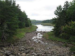
Hardscrabble River is the estuary of Wilson Stream, a small river in Washington County, Maine. From its source in Charlotte, Wilson Stream runs about 10 miles (16 km) southeast to Dennys Bay. It changes name to Hardscrabble River at about the point where it is crossed by U.S. Route 1. This section of the stream separates Pembroke on its left bank from Dennysville and Edmunds on its right.
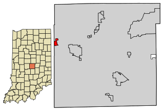
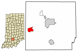
Clermont is a town in Pike and Wayne townships of Marion County, Indiana, United States. The population was 1,384 at the 2020 census. It has existed as an "included town" since 1970, when it was incorporated into Indianapolis as part of Unigov. It is legally part of Indianapolis, while retaining a town government under IC 36-3-2-5. The city is known for hosting Lucas Oil Raceway at Indianapolis, consisting of one of the nation's premier short-track ovals and also the premier American drag racing event, the NHRA U.S. Nationals.


