Dunlop Parish (Yanda County)

Last updated

Dunlop Parish
New South Wales
Louth NSW.jpg
Australia New South Wales location map blank.svg
Red pog.svg
Dunlop Parish
Coordinates 30°32′0″S145°07′0″E / 30.53333°S 145.11667°E / -30.53333; 145.11667
Postcode(s) 2840
Elevation100 m (328 ft)
LGA(s) Bourke Shire
State electorate(s) Barwon
Federal division(s) Parkes

Dunlop Parish is a civil parish, [1] of Yanda County, a cadasteral division of New South Wales; [2] a Cadastral division of New South Wales. [3] [4] [5] [6]

Contents

Location

The Parish is on the Darling River upstream of Wilcannia, New South Wales [7] [8] and down stream of Bourke, New South Wales.

The only town of the parish is Louth, New South Wales.

Geography

The topography is flat with a Köppen climate classification of BsK (Hot semi arid). [9]

The economy in the parish is based on broad acre agriculture, mainly Wheat, and sheep.

The Dunlop Ranges are in the parish.

History

The traditional owners of the area are the Barkindji people, [10] [11] The first European to the area was Thomas Mitchell (explorer).

In 1859 when Thomas Andrew Mathews, an Irish immigrant from County Louth, built a pub to serve the passing trade along the Darling River.

In 1888 the first mechanised shearing of sheep, in the world, took place at Sir Samuel McCaughey's Dunlop Station. [12]

Related Research Articles

<span class="mw-page-title-main">Cobar</span> Town in New South Wales, Australia

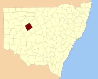
Cobar is a town in central western New South Wales, Australia whose economy is based mainly upon base metals and gold mining. The town is 712 km (442 mi) by road northwest of the state capital, Sydney. It is at the crossroads of the Kidman Way and Barrier Highway. The town and the local government area, the Cobar Shire, are on the eastern edge of the outback. At the 2016 census, the town of Cobar had a population of 3,990. The Shire has a population of approximately 4,700 and an area of 44,065 square kilometres (17,014 sq mi).

<span class="mw-page-title-main">Electoral district of Bourke</span> State electoral district of New South Wales, Australia

Bourke was an electoral district of the Legislative Assembly in the Australian state of New South Wales from 1880 to 1904, including the towns of Bourke and Cobar. It elected two members simultaneously between 1882 and 1889 increasing to three members until 1894, with each elector being able to vote for as many candidates as there were vacancies.

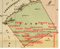
Cobar was an electoral district of the Legislative Assembly in the Australian state of New South Wales which was named after the town of Cobar. It was first created in 1894 and abolished in 1920. Cobar was recreated in 1930 and abolished in 1968.

<span class="mw-page-title-main">Irrara County</span> Cadastral in New South Wales, Australia

Irrara County is one of the 141 Cadastral divisions of New South Wales. It is located south of the border with Queensland, east of the Paroo River, and west of the Warrego River.

<span class="mw-page-title-main">Parish of Donalroe</span>

Donalroe Parish in Cobar Shire is a civil parish of Rankin County,; a Cadastral division of New South Wales.

<span class="mw-page-title-main">Parish of Budda</span>

Budda Parish in Cobar Shire is a civil parish of Rankin County,; a Cadastral division of New South Wales.

<span class="mw-page-title-main">Parish of Tankarook</span>

Tankarrok Parish in Cobar Shire is a civil parish of Rankin County,; a Cadastral division of New South Wales.

<span class="mw-page-title-main">Parish of Buckinbe</span>

Buckinbe Parish in Cobar Shire is a civil parish of Rankin County,; a Cadastral division of New South Wales.

<span class="mw-page-title-main">Parish of Wallandra</span> Civil parish in New South Wales, Australia

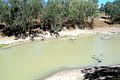
Wallandra Parish in Cobar Shire is a civil parish of Rankin County, a Cadastral division of New South Wales. The Parish is on the Darling River upstream of Wilcannia, New South Wales and is located at 30.5511°N 144.3351°E. The only town of the parish is Tilpa, New South Wales.

Cumbedore Parish, Yanda County in Bourke Shire is a civil parish of Yanda County, a cadasteral division of New South Wales.

Canpadore Parish, Yanda County in Bourke Shire is a civil parish of Yanda County, a cadasteral division of New South Wales; a Cadastral division of New South Wales.

<span class="mw-page-title-main">Dootheboy, (Yanda County)</span>

Dootheboy, in Cobar Shire is a civil parish of Yanda County a Cadastral division of New South Wales.

Bright Parish, in Cobar Shire is a civil parish of Yanda County, a Cadastral division of New South Wales.

Kenindee Parish, in Cobar Shire is a civil parish of Yanda County a Cadastral division of New South Wales.

Kenindee Parish, in Cobar Shire is a civil parish of Yanda County a Cadastral division of New South Wales.

Emu Parish, in Cobar Shire is a civil parish of Yanda County a Cadastral division of New South Wales.

Gundabooka Parish is a civil parish, of Yanda County, a cadasteral division of New South Wales; a Cadastral division of New South Wales.

<span class="mw-page-title-main">Dunlop Station (pastoral run)</span> Pastoral lease in New South Wales

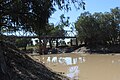
The Dunlop Station was a pastoral lease that operated as a sheep station in New South Wales. Dunlop is significant as farm with the first mechanised shearing of sheep.

Yanda Parish, is a civil parish, of Yanda County, a cadasteral division of New South Wales; a Cadastral division of New South Wales.

Loftus Parish is a civil parish of Cowper County, New South Wales; a Cadastral division of New South Wales. located at 30°13'05.0"S 146°27'57.0"E between Byrock, New South Wales and Bourke, New South Wales.

References

  1. Map of the County of Yanda, Western Division, NSW 1918.
  2. [cartographer] C.A. Orwin, [https://nla.gov.au/nla.obj-233873384/view Map of the County of Rankin : Western Division, Land Districts of Bourke, Cobar and Wilcannia, N.S.W. 1912 (New South Wales. Department of Lands Title, Sydney N.S.W. 1914).
  3. "Rankin". Geographical Names Register (GNR) of NSW. Geographical Names Board of New South Wales . Retrieved 4 August 2013. OOjs UI icon edit-ltr-progressive.svg
  4. The New atlas of Australia (John Sands, 1886) map 24.
  5. Yanda County Archived 6 May 2018 at the Wayback Machine , GEOGRAPHICAL NAMES REGISTER EXTRACT.
  6. / The New atlas of Australia, (John Sands, 1886), map 24.
  7. [cartographer] C.A. Orwin, [https://nla.gov.au/nla.obj-233873384/view Map of the County of Rankin : Western Division, Land Districts of Bourke, Cobar and Wilcannia, N.S.W. 1912 (New South Wales. Department of Lands Title, Sydney N.S.W. 1914).
  8. The New atlas of Australia (John Sands, 1886) map 24.
  9. Peel, M. C.; Finlayson, B. L.; McMahon, T. A. (2007). "Updated world map of the Köppen–Geiger climate classification". Hydrol. Earth Syst. Sci. 11: 1633–1644. doi: 10.5194/hess-11-1633-2007 . ISSN   1027-5606.(direct: Final Revised Paper)
  10. Norman Tindale's Catalogue of Australian Aboriginal Tribes
  11. Aboriginal Australia Map, David Horton (ed.), 1994 published in The Encyclopedia of Aboriginal Australia by AIATSIS.
  12. Trilby Station Archived 2 April 2012 at the Wayback Machine Retrieved 26 September 2011