Dunnottar Parish Church

Last updated

Dunnottar Parish Church
Carronside Parish Church
Dunnottar Church, Stonehaven, Aberdeenshire. East facing frontage.jpg
Dunnottar Parish Church
56°57′28″N2°13′37″W / 56.9578°N 2.2270°W / 56.9578; -2.2270
Denomination Church of Scotland
Churchmanship Reformed
Membership742
Website https://www.carronsidechurch.net/
Administration
Presbytery Presbytery of Kincardine and Deeside
Parish Carronside Church
Clergy
Minister(s) Rev Sarah Smith
Laity
Organist(s) Various

Dunnottar Parish Church is a parish church of the Church of Scotland, serving Stonehaven in the south of Aberdeenshire, Scotland. It is within the Church of Scotland's Presbytery of Kincardine and Deeside. During 2020, the congregation united to the South Parish Church in Stonehaven to form Carronside Church of Scotland. On 3 June 2021, the Rev. Sarah Smith was inducted into the charge.

Contents

Location

The church building is situated in Dunnottar woods, Stonehaven (within the AB39 postcode area), sitting high above the bank on the Carron water. It sits on the south-western periphery of Stonehaven, and is approximately a 20-minute walk from the Market Square in the centre of town. Dunnottar Castle stands approximately one and a half miles to the south-east of the church. The manse stands directly across the road to the west.

Dunnottar Parish also holds property including St Bridget's hall on Dunnottar Avenue, Stonehaven. The hall, which was built in 1887 and stands on the site of a previous church, was built to act as a missionary church to the Old Town, or 'Auld Toon', of Stonehaven. Historically morning services were held in Dunnottar Church, and evening services were held in St Bridget's. [1] St Bridget's hall is now used for the Parish Evening Communion and meeting of the Church's organisations. It is also let out to community organisations. [2]

In 2021, a footpath was created which crossed Toucks Burn (a tributary to the Carron Water, linking the church and the nearby Dunnottar Park housing development. [3]

Church interior Dunnottar Church interior, Stonehaven, Aberdeenshire.jpg
Church interior

Buildings

The church, in its present location, was re-built in 1852 and later extended in 1869. [4] It again underwent major reconstruction in 1903, which made it considerably larger [5] when a nave and chancel were added, turning the previously rectangular building into a cruciform shape. [6] The building recently underwent more renovations, this time to make it more accessible, and to include a multi-purpose activity room. [7] [8] [9]

The churchbell was cast in 1793 by Andrew Lawson, the last of the Old Aberdeen founders; is supposed to be one of the best examples of his work. In his book Church bells of Kincardineshire, F.C. Eeles wrote:

The Marischal Aisle The Marischal Aisle, Dunnottar Church, Aberdeenshire.jpg
The Marischal Aisle

Insignificant though they are, those few fleur-de-lys used on the Dunnottar bell are perhaps one of the very latest survivals of the ecclesiastical art of the Middle Ages. This is perfectly possible because founders' stamps were handed on from one founder to another and in England there are several cases of the use of medieval stamps at the end of the 17th century. Moreover, in the foreign mouldings and outline of the Dunnottar bell, we see a lingering survival of that continental influence which ever since the English wars in the 14th century had held such sway in Scotland.

The Marischal Aisle (nowadays a mausoleum), sits in the current church grounds and was first built in 1582 by George Keith, the 5th Earl Marischal of Scotland and founder of Marischal College in Aberdeen. [10]

Covenanters Stone

Covenanters memorial Covenanters memorial, Dunnottar Church, Stonehaven, Aberdeenshire.jpg
Covenanters memorial

One feature of the churchyard is the Covenanters Stone, a reminder of the Covenanters who were imprisoned in nearby Dunnottar Castle. This stone is said to have been the inspiration for Sir Walter Scott in his novel Old Mortality , whereby he watched Robert Patterson carefully and lovingly restore the lettering on the Covenanters Stone. [11]

The stone reads:

HERE LYES JOHN STOT ATCHISON JAMES RUSSELL & WILLIAM BROUN AND ONE WHOSE NAME WEE HAVE NOT GOTTEN AND TWO WOMEN WHOSE NAMES ALSO WEE KNOW NOT AND TWO WHO PERISHED COMING DOUNE THE ROCK ONE WHOSE NAME WAS JAMES WATSON THE OTHER NOT KNOWN WHO ALL DIED PRISONERS IN DUNNOTTAR CASTLE ANNO 1685 FOR THEIR ADHERENCE TO THE WORD OF GOD AND SCOTLAND’S COVENANTED WORK OF REFORMATION REV CHAP 12 VERSE 11. [12]

See also

Related Research Articles

<span class="mw-page-title-main">Stonehaven</span> Town in Aberdeenshire, Scotland

Stonehaven is a town in Scotland. It lies on Scotland's northeast coast and had a population of 11,602 at the 2011 Census. After the demise of the town of Kincardine, which was gradually abandoned after the destruction of its royal castle in the Wars of Independence, the Scottish Parliament made Stonehaven the successor county town of Kincardineshire. It is currently administered as part of the Aberdeenshire Council Area. Stonehaven had grown around an Iron Age fishing village, now the "Auld Toon", and expanded inland from the seaside. As late as the 16th century, old maps indicate the town was called Stonehyve, Stonehive, Timothy Pont also adding the alternative Duniness. It is known informally to locals as Stoney.

<span class="mw-page-title-main">Kincardineshire</span> Historic county in Scotland

Kincardineshire, also known as the Mearns, is a historic county, registration county and lieutenancy area on the coast of northeast Scotland. It is bounded by Aberdeenshire on the north and west, and by Angus on the south.

<span class="mw-page-title-main">Dunnottar Castle</span> Ruined castle in Scotland

Dunnottar Castle is a ruined medieval fortress located upon a rocky headland on the north-eastern coast of Scotland, about 2 miles south of Stonehaven. The surviving buildings are largely of the 15th and 16th centuries, but the site is believed to have been fortified in the Early Middle Ages. Dunnottar has played a prominent role in the history of Scotland through to the 18th-century Jacobite risings because of its strategic location and defensive strength.

<span class="mw-page-title-main">Clan Keith</span> Highland and Lowland Scottish clan

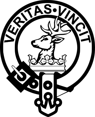
Clan Keith is a Highland and Lowland Scottish clan, whose Chief historically held the hereditary title of Marischal, then Great Marischal, then Earl Marischal of Scotland.

<span class="mw-page-title-main">William Keith, 7th Earl Marischal</span> Scottish noble

William Keith, 7th Earl Marischal was a Scottish nobleman and Covenanter. He was the eldest son of William Keith, 6th Earl Marischal.

<span class="mw-page-title-main">Kincardine and Mearns</span>

Kincardine and Mearns is one of six area committees of the Aberdeenshire council area in Scotland. It has a population of 38,506. There are significant natural features in this district including rivers, forests, mountains and bogs.

<span class="mw-page-title-main">Muchalls Castle</span> Castle in Scotland, UK

Muchalls Castle stands overlooking the North Sea in the countryside of Kincardine and Mearns, Aberdeenshire, Scotland. The lower course is a well-preserved Romanesque, double-groined 13th-century tower house structure, built by the Frasers of Muchalls. Upon this structure, the 17th-century castle was begun by Alexander Burnett of Leys and completed by his son, Sir Thomas Burnett, 1st Baronet, in 1627. The Burnetts of Leys built the remaining four-storey present-day castle.

<span class="mw-page-title-main">Fetteresso Castle</span> Scottish estate

Fetteresso Castle is a 14th-century tower house, rebuilt in 1761 as a Scottish Gothic style Palladian manor, with clear evidence of prehistoric use of the site. It is situated immediately west of the town of Stonehaven in Kincardineshire, slightly to the west of the A90 dual carriageway. Other notable historic fortified houses or castles in this region are Dunnottar Castle, Muchalls Castle, Fiddes Castle, Cowie Castle and Monboddo House.

<span class="mw-page-title-main">Stonehaven Tolbooth</span> Historic building in Stonehaven, Scotland

The Stonehaven Tolbooth is a late 16th-century stone building originally used as a courthouse and a prison in the town of Stonehaven, Aberdeenshire, Scotland. Constructed of local Old Red Sandstone, the prison probably attained its greatest note, when three local Episcopalian clergymen were imprisoned for holding services for more than nine people. Lying midway along the old north quay of the Stonehaven Harbour, the present day Tolbooth serves as a local museum with a restaurant on the floor above the ground floor. It is a category A listed building.

<span class="mw-page-title-main">Bridge of Dee</span>

The Bridge of Dee or Brig o Dee is a road bridge over the River Dee in Aberdeen, Scotland. The term is also used for the surrounding area of the city. Dating from 1527, the bridge crosses at what was once the City of Aberdeen's southern boundary.

<span class="mw-page-title-main">George Keith, 5th Earl Marischal</span> Scottish politician

George Keith, 5th Earl Marischal (c. 1553–1623) was a Scottish nobleman and Earl Marischal. He succeeded as earl on 7 October 1581, upon the death of his grandfather, William Keith, 4th Earl Marischal.

The Burn of Elsick is a coastal stream in Aberdeenshire, Scotland that discharges to the North Sea. This watercourse drains primarily agricultural lands and enters the North Sea at Newtonhill.

<span class="mw-page-title-main">Causey Mounth</span>

The Causey Mounth is an ancient drovers' road over the coastal fringe of the Grampian Mountains in Aberdeenshire, Scotland. This route was developed as the main highway between Stonehaven and Aberdeen around the 12th century AD and it continued to function as the principal route connecting these two cities until the mid 20th century, when modern highway construction of the A90 road occurred in this area. There are extant paved and usable sections of this road over part of the alignment; however, many parts of the ancient route are no more than footpaths, and in some cases the road has vanished into agricultural fields. Constructed in the Middle Ages, the Causey Mounth was created as an elevated rock causeway to span many of the boggy areas such as the Portlethen Moss. A considerable portion of the alignment of the Causey Mounth is illustrated on the UK Ordnance Survey Map, although a large fraction of the route cannot be navigated by a conventional passenger vehicle.

<span class="mw-page-title-main">Cammachmore</span>

Cammachmore is a hamlet in the coastal region near the North Sea in Aberdeenshire. It lies slightly west of the A92 road and the ancient Causey Mounth passes through the community. Historic Elsick House is situated due west of Cammachmore. Other nearby historic features include Gillybrands, Saint Ternan's Church, Muchalls Castle and the Lairhillock Inn.

<span class="mw-page-title-main">Cookney</span>

Cookney is a hamlet in Aberdeenshire, Scotland in proximity to Netherley in the Mounth of the Grampian Highlands. The community is situated on a hilltop approximately 5 miles (8 km) northwest of Stonehaven, about 3 miles (5 km) northwest of the Bridge of Muchalls, and about 2 miles (3 km) west of Muchalls Castle. From Cookney a portion of the ancient route of the Causey Mounth is visible to the east near Whinward Farm, although the track is not truly recognizable from that distance. The Cookney Church is a prominent historic landmark of Cookney.

<span class="mw-page-title-main">Banchory-Devenick</span>

Banchory-Devenick is a hamlet approximately two kilometres south of the city of Aberdeen, Scotland in the Lower Deeside area of Aberdeenshire. The hamlet should not be confused with the historic civil parish of the same name which spanned the River Dee until 1891, its northern part lying in Aberdeenshire and its southern part in Kincardineshire. In that year the northern part became part of the neighbouring parish of Peterculter, the southern part remaining as the parish of Banchory-Devenick. The hamlet of Banchory-Devenick is on the B9077 road, and the ancient Causey Mounth passes directly through it. An historic graveyard dating to 1157 AD is present within Banchory-Devenick. Other historic features in the vicinity include Saint Ternan's Church, Muchalls Castle and the Lairhillock Inn.

<span class="mw-page-title-main">Saint Ternan's Church</span>

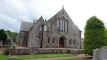
Saint Ternan's Church is an Episcopal church in the Diocese of Brechin, near Muchalls in Aberdeenshire, Scotland.

<span class="mw-page-title-main">Chapel of St Mary and St Nathalan</span>

The Chapel of St. Mary and St. Nathalan is a ruined chapel overlooking the North Sea immediately north of Stonehaven, in the Mearns of Scotland, along the northern shoreline of Stonehaven Bay. The founding of this Christian place of worship is associated with St. Nathalan. who lived circa 650 AD. The structure is alternatively known as Cowie Chapel. The chapel is at the point where the Highland Boundary Fault meets the sea and so is on the dividing line between the highlands and lowlands of Scotland.

<span class="mw-page-title-main">John Longmuir (poet)</span>

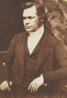
John Longmuir MA LLD (1803–1883) was a Scottish minister of first the Church of Scotland then the Free Church of Scotland. He is mainly remembered as a poet and antiquary.

<span class="mw-page-title-main">Dunnicaer</span> Sea stack and remains of Pictish hill fort in Aberdeenshire, Scotland

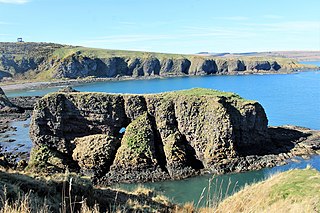
Dunnicaer, or Dun-na-caer, is a precipitous sea stack just off the coast of Aberdeenshire, Scotland, between Dunnottar Castle and Stonehaven. Despite the unusual difficulty of access, in 1832 Pictish symbol stones were found on the summit and 21st-century archaeology has discovered evidence of a Pictish hill fort which may have incorporated the stones in its structure. The stones may have been incised in the third or fourth centuries AD but this goes against the general archaeological view that the simplest and earliest symbol stones date from the fifth or even seventh century AD.

References

  1. Christie, E. The Haven under the Hill: The tory of Stonehaven. Stonehaven: James A Bruce. p. 40.
  2. http://www.dunnottarchurch.net/property/stbridgets.html Archived 2012-02-26 at the Wayback Machine Dunnottar Parish Church official website
  3. Roberts, Karen. "Footpath over north-east burn restored for residents". Evening Express. Retrieved 26 March 2021.
  4. Christie, E. The Haven under the Hill: The Story of Stonehaven. Stonehaven: James A Bruce. p. 39.
  5. Ritchie, G J (1989). Stonehaven of Old. Stonehaven: Stonehaven Heritage Society. p. 50.
  6. Swapp, G D (2008). Dunnottar Woods and House: 1782-2008. Stonehaven: Stonehaven Heritage Society. p. 35.
  7. "Stonehaven church aiming to raise GBP139,000". Aberdeen Press & Journal. Aberdeen, Scotland: Europe Intelligence Wire. 18 March 2004. Retrieved 17 January 2010.
  8. "Celebrations for Dunnottar Church". Aberdeen Press & Journal. Aberdeen, Scotland: Europe Intelligence Wire. 15 May 2006. Retrieved 17 January 2010.
  9. "Fundraising efforts for ancient church reach GBP80,000". Aberdeen Press & Journal. Aberdeen, Scotland: Europe Intelligence Wire. 19 February 2005. Retrieved 17 January 2010.
  10. Simpson, W D (1976). Dunnottar Castle: Historical and Descriptive. Aberdeen: Milne & Wyllies. p. 60.
  11. Swapp, GD (2008). Dunnottar Woods and House: 1782-2008. Stonehaven: Stonehaven Heritage Society. p. 35.
  12. "Dunnottar Church & Kirkyard". St Marys Stonehaven. Retrieved 30 September 2017.