
Porter County is a county in the U.S. state of Indiana. As of 2010, the population was 164,343. The county seat is Valparaiso. The county is part of Northwest Indiana, as well as the Chicago metropolitan area.

Newton County is a county located near the northwestern corner of the U.S. state of Indiana. As of 2010, the population was 14,244. This county is part of Northwest Indiana as well as the Chicago metropolitan area. The county seat is Kentland. The county is divided into 10 townships which provide local services.

Jasper County is a county located in the U.S. state of Indiana. As of 2010, the population was 33,478. The county seat is Rensselaer.

Wheatfield is a town in Wheatfield Township, Jasper County, Indiana, United States. The population was 853 at the 2010 census.

Ladoga is a town in Clark Township, Montgomery County, in the U.S. state of Indiana. The population was 985 at the 2010 census.
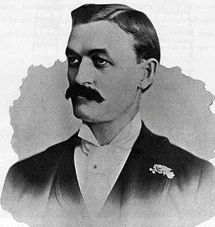
George Washington Gale Ferris Jr. was an American civil engineer. He is mostly known for creating the original Ferris Wheel for the 1893 Chicago World's Columbian Exposition.

The Kankakee River is a tributary of the Illinois River, approximately 133 miles (214 km) long, in the Central Corn Belt Plains of northwestern Indiana and northeastern Illinois in the United States. At one time, the river drained one of the largest wetlands in North America and furnished a significant portage between the Great Lakes and the Mississippi River. Significantly altered from its original channel, it flows through a primarily rural farming region of reclaimed cropland, south of Lake Michigan.

DeMotte is a town in Keener Township, Jasper County, Indiana, United States. The population was 3,814 at the 2010 census.

Kankakee Township is one of thirteen townships in Jasper County, Indiana, United States. As of the 2010 census, its population was 988 and it contained 410 housing units.

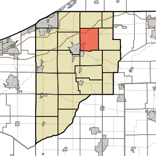
Wheatfield Township is one of thirteen townships in Jasper County, Indiana, United States. As of the 2010 census, its population was 4,395 and it contained 1,658 housing units.

Cass Township is one of twelve townships in Pulaski County, Indiana, United States. As of the 2010 census, its population was 878 and it contained 376 housing units.

Railroad Township is one of nine townships in Starke County, in the U.S. state of Indiana. As of the 2010 census, its population was 1,226 and it contained 549 housing units.
Kankakee Township is one of twenty-one townships in LaPorte County, Indiana. As of the 2010 census, its population was 4,830 and it contained 1,859 housing units.

Tefft is an unincorporated community in Kankakee Township, Jasper County, Indiana.
Asphaltum was an unincorporated community in Gillam Township, Jasper County, Indiana.
Byron is an unincorporated community in Kankakee Township, LaPorte County, Indiana.

Fish Lake is an unincorporated community and census-designated place in Lincoln Township, LaPorte County, Indiana, United States. It is located where Indiana State Road 4 passes between Upper Fish Lake and Lower Fish Lake. These lakes feed the Kankakee River. As of the 2010 census, the population of the community was 1,016.

Rolling Prairie is an unincorporated community and census-designated place (CDP) in Kankakee Township, LaPorte County, Indiana, United States. As of the 2010 census, it had a population of 582.

The Kankakee Outwash Plain is a flat plain interspersed with sand dunes in the Kankakee River valley in northwestern Indiana and northeastern Illinois of the United States. It is just south of the Valparaiso Moraine and was formed during the Wisconsin Glaciation. As the glacier, stopped at the Valparaiso Moraine, melted, the meltwater was carried away to the outwash plain. On the south side of the moraine, where the elevation drops, the meltwaters eroded away valleys, carrying sand and mud with them. As the muddy meltwater reached the valley where the slope lessened, the water slowed, depositing the sand on the outwash plain. This created a smooth, flat, and sandy plain. Before its draining, the Kankakee Marsh, located on the outwash plain, was one of the largest freshwater marshes in the United States.

Tassinong is an unincorporated rural community in Porter County, Indiana, south of the city of Valparaiso. The community includes an historic marker claiming it to be a French mission and trading post in 1673, which would make it the oldest European settlement in Indiana as well as in neighboring Illinois.


