Newmarket is a census-designated place (CDP) and the main village in the town of Newmarket in Rockingham County, New Hampshire, United States. The population of the CDP was 5,297 at the 2010 census, out of 8,936 people in the entire town of Newmarket.

Newmarket is a town in Rockingham County, New Hampshire, United States. The population was 8,936 at the 2010 census. Some residents are students and employees at the nearby University of New Hampshire in Durham.

Durham is a town in Strafford County, New Hampshire, United States. The population was 14,638 at the 2010 census. Durham is home to the University of New Hampshire.

The Oyster River is a 17-mile-long (27 km) river in Strafford County, southeastern New Hampshire, United States. It rises in Barrington, flows southeast to Lee, then east-southeast in a serpentine course past Durham to meet the entrance of Great Bay into Little Bay. The bays are tidal inlets of the Atlantic Ocean, to which they are connected by a tidal estuary, the Piscataqua River. The freshwater portion of the river is 14.1 miles (22.7 km) long, and the tidal river extends 2.9 miles (4.7 km) from Durham to Great Bay.
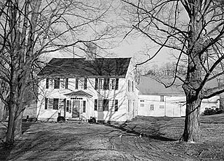
The John Sullivan House is a historic house at 21 Newmarket Road in Durham, New Hampshire. A National Historic Landmark, it was the home of American Revolutionary War General John Sullivan (1740-1795), who later became President of New Hampshire.
The Elm Street Historic District is a rural historic district in southern Hatfield, Massachusetts. It encompasses a landscape that has seen agricultural use since 17th century colonial days, including fields now used for tobacco farming, and historic properties located along five roads: Elm Street, Scotland Road, Sunset Road, Brook Hollow Road, and Little Neponset Road. The district is bounded on its south by the Connecticut River, on its east and north by the Mill River, with a small portion of land border in the northeast which cuts off a large meander in the river. This section, near the junction of Elm and Prospect Streets, is also where this district abuts the Mill-Prospect Street Historic District, which runs north along Prospect Street, and its eastern boundary abuts the Hatfield Center Historic District. Its western boundary is roughly a north-south line in the area of the junction of Elm and Dwight Streets.

The Front Street Historic District in Exeter, New Hampshire, encompasses a portion of the town's historic center. The district extends from Swasey Pavilion, at the junction of Front and Water streets, southwesterly along Front Street to Gale Park, about five blocks. Front Street is one of Exeter's oldest roads, and is lined with a series of 18th and 19th-century civic, religious, and residential structures, many of which are well preserved. The district was listed on the National Register of Historic Places (NRHP) in 1973.

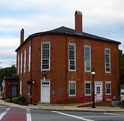
The Waterloo Historic District encompasses the site of one of the first mills on the Warner River, near the Waterloo Falls in Warner, New Hampshire. The 50-acre (20 ha) district includes most of the original 60-acre (24 ha) land grant for the mill site. It extends along Waterloo Street and Newmarket Street for a length of about 1 mile (1.6 km), from where Newmarket Street crosses the Warner River to where Waterloo Street crosses a brook. In addition to its industrial history, the district is notable for being home to two nationally known politicians: William E. Chandler (1835-1917), who served as United States Senator and as United States Secretary of the Navy, and Nehemiah G. Ordway (1828-1907), the seventh governor of the Dakota Territory.

The East Jaffrey Historic District is a historic district running roughly along NH Route 124 through Jaffrey, New Hampshire. It encompasses what is now the economic and civic heart of the town, centered on the Jaffrey Mills and the crossing of the Contoocook River by Route 124. It extends as far west as St. Patrick's Church beyond Charlonne Street and as far east as the US Post Office building at Route 124 and Ellison Street. To the north it extends along Peterborough Street to Christian Court, and to the south it extends along River Street and School Street to their junction. The district includes early 19th-century residential structures, as well as industrial buildings and housing associated with the Jaffrey Mills which arose in the mid-19th century. The district was added to the National Register of Historic Places in 2002.

The Head of the River Historic District is a historic district encompassing a village area at the head of navigation of the Acushnet River, which separates Acushnet and New Bedford, Massachusetts. The village is centered at the junction of Tarkin Hill Road, River Road, and Mill Road in New Bedford, and Main Street in Acushnet. The area went through two significant periods of development: the first was in the late 18th and early 19th century, and the second was in the early 20th century. The district was listed on the National Register of Historic Places in 2009.

The Central Square Historic District of Bristol, New Hampshire, encompasses the central commercial district of the town. The square is a four-sided space near the junction of six roadways in the center of Bristol, just north of the Newfound River and west of the Pemigewasset River. The district includes all of the buildings that are arrayed around the square, as well as one contemporary commercial building located just south of the Newfound River on South Main Street. The district was listed on the National Register of Historic Places in 1983.

The Haverhill Corner Historic District encompasses the early civic center of Haverhill, New Hampshire, United States. The district is focused on the junction of New Hampshire Route 10 and Court Street, which was historically a major through route. Court Street is flanked at the junction by a pair of large grassy common areas which are bounded by School Street and Route 10. Buildings, predominantly Federal in character and built in the late 18th and early 19th centuries, are arrayed around these commons, and historic buildings line Route 10 and Court Street for a short distance away from the commons. Prominent buildings in the district include the 1827 Federal-style First Congregational Church, the 1840 former courthouse that now houses the public library and local historical society, and the Romanesque Revival 1897 Haverhill Academy Junior High School building. The area declined in importance after the railroad bypassed it, resulting in the gradual relocation of civic functions to the Woodsville area. The district was listed on the National Register of Historic Places in 1987.
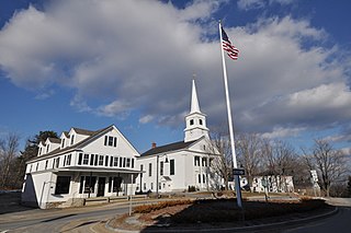
The Dublin Village Historic District encompasses the historic village center of Dublin, New Hampshire. Dublin's center developed in the 19th century after its original village center was abandoned due to harsher winter conditions nearer Dublin Pond. The district extends along Main Street from its junction with Lake Street in the west to the junction with Old County Road in the east, and includes sections of Old Common Road, Harrisville Road, and Church Street. The district was listed on the National Register of Historic Places in 1983.
The Enfield Village Historic District encompasses the historic 19th century village center of Enfield, New Hampshire. The district was listed on the National Register of Historic Places in 2010. Multiple buildings of the district were added to the New Hampshire State Register of Historic Places in 2012.

The Bennington Village Historic District of Bennington, New Hampshire encompasses the 19th-century center of the village. Growth of the village followed a typical pattern for rural New Hampshire towns, based in this case around the growth in the early 19th century of the paper industry, which continues to be a significant economic force in the community. The district is centered on the junctions of Main, Center, and School Streets with Bible Hill Road and Francestown Road. The district was listed on the National Register of Historic Places in 2010.

The Charlestown Main Street Historic District encompasses the historic heart of Charlestown, New Hampshire. It is located along Main Street, roughly between Lower Landing Road and Bridge Street, and encapsulates more than two hundred years of the town's history. The district was listed on the National Register of Historic Places in 1987.

The Exeter Waterfront Commercial Historic District encompasses the historic commercial and residential waterfront areas of Exeter, New Hampshire. The district extends along the north side of Water Street, roughly from Main Street to Front Street, and then along both sides of Water and High streets to the latter's junction with Portsmouth Street. It also includes properties on Chestnut Street on the north side of the Squamscott River. This area was where the early settlement of Exeter took place in 1638, and soon developed as a shipbuilding center. The district was listed on the National Register of Historic Places in 1980. It was enlarged in 1986 to include the mill complex of the Exeter Manufacturing Company on Chestnut Street.

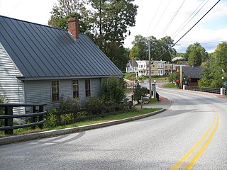
The Newmarket Industrial and Commercial Historic District encompasses the heart of a distinctive 19th century mill town, Newmarket, New Hampshire. Its mill complex is regionally distinctive for its extensive use of stone from an early date, and the town is relatively well-preserved due to a significant economic decline after the mills closed in 1920. The district was listed on the National Register of Historic Places in 1980. The Stone School, listed in 1978, is a contributing resource.

The North Charlestown Historic District encompasses a 19th-century rural village in Charlestown, New Hampshire. Located about 5 miles (8 km) north of the town's center, the district includes a small cluster of buildings along New Hampshire Route 12A that is a remnant portion of a larger agricultural village. First settled in the 1750s, the oldest buildings in the district date to the 1790s, and most of the major buildings were built in the 19th century. Its economy was based on lumber and farming. The village was once considered a much larger, dispersed settlement, but construction of New Hampshire Route 11 in the 1960s separated some of the more remote parts of the village from its nucleus, which was bypassed by that construction.
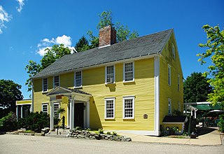
Hill-Woodman-Ffrost House in Durham, New Hampshire is one of the oldest buildings in the State of New Hampshire and is located within the Durham Historic District. It "has an ell that is believed to date to 1649." The building is currently a hotel known as the Three Chimneys Inn-Ffrost Sawyer Tavern.