
Plymouth County is a county in the U.S. state of Massachusetts, south of Boston. As of the 2020 census, the population was 530,819. Its county seats are Plymouth and Brockton. In 1685, the county was created by the Plymouth General Court, the legislature of Plymouth Colony, predating its annexation by the Massachusetts Bay Colony.

Myles Standish was an English military officer and colonist. He was hired as military adviser for Plymouth Colony in present-day Massachusetts, United States by the Pilgrims. Standish accompanied the Pilgrims on the ship Mayflower and played a leading role in the administration and defense of Plymouth Colony from its foundation in 1620. On February 17, 1621, the Plymouth Colony militia elected him as its first commander and continued to re-elect him to that position for the remainder of his life. Standish served at various times as an agent of Plymouth Colony on a return trip to England, as assistant governor of the colony, and as its treasurer.

Duxbury is a historic seaside town in Plymouth County, Massachusetts, United States. A suburb located on the South Shore approximately 35 miles (56 km) to the southeast of Boston, the population was 16,090 at the 2020 census.

The piping plover is a small sand-colored, sparrow-sized shorebird that nests and feeds along coastal sand and gravel beaches in North America. The adult has yellow-orange-red legs, a black band across the forehead from eye to eye, and a black stripe running along the breast line. This chest band is usually thicker in males during the breeding season, and it is the only reliable way to tell the sexes apart. The bird is difficult to see when it is standing still, as it blends well with open, sandy beach habitats. It typically runs in short, quick spurts and then stops.

Scituate is a seacoast town in Plymouth County, Massachusetts, United States, on the South Shore, midway between Boston and Plymouth. The population was 19,063 at the 2020 census.
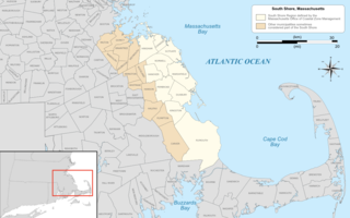
The South Shore of Massachusetts is a geographic region stretching south and east from Boston toward Cape Cod along the shores of Massachusetts Bay and Cape Cod Bay. It is subject to varying descriptions including municipalities in eastern Norfolk and Plymouth counties. The South Shore is an affluent area. The median income of the region as of 2020 is $104,691. The median home value of the region as of 2020 is $574,831.

Revere Beach is a public beach in Revere, Massachusetts, measuring over three miles (4.8 km) long and located about five miles (8 km) north of downtown Boston. In 1875, a rail link was constructed to the beach, leading to its increasing popularity as a summer recreation area, and in 1896, it became the first public beach in the United States. It is still easily accessible from Boston by the MBTA subway's Blue Line, and can accommodate as many as one million visitors in a weekend during its annual sand sculpture competition. The Revere Beach Reservation and Revere Beach Reservation Historic District is listed on the National Register of Historic Places.

Cape Poge Wildlife Refuge is a wildlife refuge on Chappaquiddick Island owned and managed by The Trustees of Reservations. The refuge consists of 516 acres (2.09 km2) and includes the 1893 Cape Poge Lighthouse.

Nantasket Beach is a beach in the town of Hull, Massachusetts. It is part of the Nantasket Beach Reservation, administered by the state Department of Conservation and Recreation. The shore has fine, light gray sand and is one of the most highly rated beaches in Greater Boston. Due to its gentle slope, at low tide, the beach extends several hundred yards in width, forming tide pools that have become a well known, pictoresque characteristic of the site, renowned for their reflections of the sunsets and sunrises. The northern part of the beach is private, administered by the Town of Hull, and does not allow visitors to park except as guests of residents. The beach is a habitat for federally protected species, including the Piping Plover, Least Tern, and occasionally harbor seals.

Plymouth Bay is a small, well-protected bay of the Atlantic Ocean on the western shore of larger Cape Cod Bay along the coastline of the Commonwealth of Massachusetts. Plymouth Bay retains historical significance for the landing at Plymouth Rock in 1620 by the Pilgrims aboard the Mayflower who proceeded to establish the first permanent Northern European settlement in North America at Plymouth Colony.

Crane Beach is a 1,234-acre (4.99 km2) conservation and recreation property located in Ipswich, Massachusetts, immediately north of Cape Ann. It consists of a four-mile-long (6 km) sandy beachfront, dunes, and a maritime pitch pine forest. Five and a half miles of hiking trails through the dunes and forest are accessible from the beachfront.

Plymouth Beach is a small village located in Plymouth, Massachusetts, United States. It is located directly south of Plymouth Center, and is adjacent to Plimoth Plantation. Plymouth Beach consists of a motel, a restaurant and a small beachside community along Warren Cove.

Plymouth Light, also known as Gurnet Light, is a historic lighthouse located on Gurnet Point at the entrance to Plymouth Bay in the town of Plymouth, Massachusetts. The light is accessible only by passing through the town of Duxbury, which lies to the north. The tower is located inside the earthworks of Fort Andrew, which existed in the Civil War, War of 1812, and Revolutionary War.

Gurnet Point, also known as The Gurnet, is located at the end of the peninsula at the entrance to Plymouth Bay in Plymouth, Massachusetts, and is a headland and the small private settlement located on it. The Pilgrims who settled Plymouth in 1620 named it Gurnett's Nose for its resemblance to headlands in the English Channel where gurnett fish were plentiful. The Gurnet is the home of Plymouth (Gurnet) Lighthouse as well as Fort Andrew from the Revolutionary War and Civil War. Its access by land is either from Gurnet Road in Duxbury or from the Powder Point Bridge at Duxbury Beach 5 miles to the north by foot or by 4-wheel drive beach buggies, but access is restricted to property owners, residents and their guests, except for once a year on Memorial Day when the lighthouse is open to the public.
Fort Andrew is a former fort built as Gurnet Fort in 1776 for the American Revolutionary War on Gurnet Point in Plymouth, Massachusetts. It became a federal fort and was rebuilt in 1808, and again in 1863 during the Civil War when it received its current name. It is named for John A. Andrew, governor of Massachusetts 1861–1866. In 1863 Fort Standish was built nearby on Saquish Head. After the war, the federal government declared Fort Andrew an inactive military reservation in 1869. The reservation was sold in 1926 and mostly became private property, except for the US Coast Guard light station. A World War II fire control tower was built on the parapet of the old fort. Plymouth lighthouse is also on Gurnet Point, and was moved inside the fort's earthworks to protect it from beach erosion in 1997–1998.
Duxbury Bay is a bay on the coast of Massachusetts in the United States. The west shore of the bay is the town of Duxbury, Massachusetts; and the bay is formed by a sandbar called The Gurnet extending southeasterly from Marshfield, Massachusetts into Cape Cod Bay. The town of Marshfield was named for the estuarine wetland at the north end of the bay. The bay opens southerly toward Plymouth, Massachusetts between Captains Hill to the west and Saquish Head to the east.

The Myles Standish Burial Ground in Duxbury, Massachusetts is, according to the American Cemetery Association, the oldest maintained cemetery in the United States.

The Duxbury Rural and Historical Society (DRHS) is a non-profit organization in Duxbury, Massachusetts founded in 1883. Its mission is to "preserve and promote the heritage and rural character of the town of Duxbury and its environs." The DRHS owns several historic buildings, operates a library and archives, and maintains approximately 140 acres of conservation land in Duxbury.
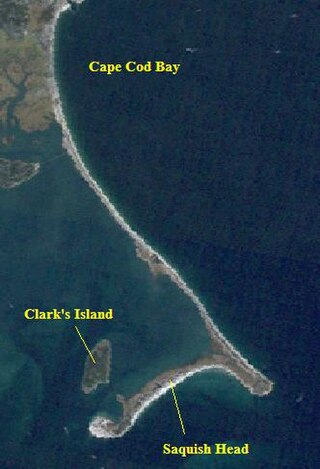
Saquish Beach, sometimes simply referred to as Saquish, is a beach and headland located at the end of the peninsula at the entrance to Plymouth Bay in Plymouth, Massachusetts. A small private settlement of summer cottages line the beach and headland, sometimes referred to as Saquish Neck and Saquish Head respectively. It is located east of Clark's Island and west of Gurnet Point. Its only access by land is from the Powder Point Bridge at Duxbury Beach, 5 miles to the north by foot or by 4-wheel drive beach buggies. As a private beach, access is restricted to property owners, residents, and their guests.

The Bluefish River is a stream in Duxbury, Massachusetts ending in a tidal river estuary that was the center of an active shipbuilding industry during the early 19th century. Its source is a set of small ponds located near the intersection of Partridge Road and Washington Street, about one-third of a mile from Hall's Corner in Duxbury. The river is fed by Hounds Ditch Brook which empties into the Bluefish at the tidal estuary. The river contains Duxbury’s second anadromous fish run, with a privately-owned fish ladder south of Harrison Street. A large portion of the northern shore of the Bluefish River estuary is occupied by the Capt. David Cushman Preserve operated by the Wildlands Trust which contains walking trails with views of the estuary. Near its mouth, the river passes under the stone Bluefish River Bridge, a local landmark and part of the Old Shipbuilders Historic District. The river discharges into Duxbury Bay between Long Point and Bumpus Park.


