
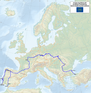
The E3 European long distance path, or just E3 path, is a 6,950-kilometre (4,320 mi) long-distance footpath that is planned to run from the Portuguese coast to the Black Sea in Bulgaria. It is one of the network of European long-distance paths.
The E3 European long distance path, or just E3 path, is a 6,950-kilometre (4,320 mi) long-distance footpath that is planned to run from the Portuguese coast to the Black Sea in Bulgaria. It is one of the network of European long-distance paths.
The completed sections of the route pass through Spain, France, Luxembourg, Belgium, Germany, the Czech Republic, Slovakia, a short stretch in Poland, Hungary, Romania, and Bulgaria.
It is planned to extend the route into Portugal to end at Cape St. Vincent.


This article's use of external links may not follow Wikipedia's policies or guidelines.(February 2024) |
| | This trail or long-distance path-related article is a stub. You can help Wikipedia by expanding it. |
The Peddars Way is a long distance footpath that passes through Suffolk and Norfolk, England.

The Low Tatras or Low Tatra is a mountain range of the Inner Western Carpathians in central Slovakia.

Žilina is a city in north-western Slovakia, around 170 kilometres (110 mi) from the capital Bratislava, close to both the Czech and Polish borders. It is the fourth largest city of Slovakia with a population of approximately 80,000, an important industrial center, the largest city on the Váh river, and the seat of a kraj and of an okres. It belongs to the Upper Váh region of tourism.

The South Downs Way is a long distance footpath and bridleway running along the South Downs in southern England. It is one of 16 National Trails in England and Wales. The trail runs for 160 km (100 mi) from Winchester in Hampshire to Eastbourne in East Sussex, with about 4,150 m (13,620 ft) of ascent and descent.

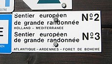
The GR footpaths are a network of long-distance walking trails in Europe, mostly in France, Belgium, the Netherlands, and Spain. They go by the following names: French: sentier de grande randonnée, West Flemish: Groteroutepad, Dutch: Langeafstandwandelpad, Spanish: sendero de gran recorrido, Portuguese: percurso pedestre de grande rota – generally meaning "long trail" or more literally "great route". The trails in France alone cover approximately 60,000 kilometres (37,000 mi). Trails are blazed with characteristic marks consisting of a white stripe above a red stripe. These appear regularly along the route, especially at places such as forks or crossroads.
Europe, the westernmost portion of Eurasia, is often divided into regions and subregions based on geographical, cultural or historical factors. Since there is no universal agreement on Europe's regional composition, the placement of individual countries may vary based on criteria being used. For instance, the Balkans is a distinct geographical region within Europe, but individual countries may alternatively be grouped into South-eastern Europe or Southern Europe.
EuroVelo is a network of 17 long-distance cycling routes criss-crossing Europe, in various stages of completion. When completed, the EuroVelo network's total length will be almost 90,000 km (56,000 mi). As of November 2022 more than 56,000 km (35,000 mi) were in place. EuroVelo is a project of the European Cyclists' Federation (ECF).
Martin is a city in northern Slovakia, situated on the Turiec river, between the Malá Fatra and Veľká Fatra mountains, near the city of Žilina. The population numbers approximately 54,000, which makes it the ninth-largest city in Slovakia. It is the center of the Turiec region and the District of Martin.

Trail blazing or way marking is the practice of marking paths in outdoor recreational areas with signs or markings that follow each other at certain, though not necessarily exactly defined, distances and mark the direction of the trail.

Veľká Fatra is a mountain range in the Western Carpathians in Slovakia. The Veľká Fatra lie to the southeast of the better known Malá (Lesser) Fatra mountains and are less developed, as well as being lower.

Malá Fatra is a mountain range in the Western Carpathians in the north-west of Central Slovakia. In the geomorphological system, it is a part of the Fatra-Tatra Area.
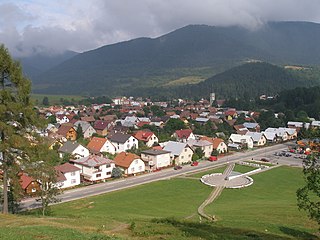
Terchová is a large village and municipality in the Malá Fatra mountains in the Žilina District in the Žilina Region of northern Slovakia.

Rajecké Teplice is a spa town in the Žilina District, Žilina Region in northern Slovakia.

Košťany nad Turcom is a village and municipality in Martin District, in Turiec territory, and in Žilina Region of northern Slovakia.

A long-distance trail is a longer recreational trail mainly through rural areas used for hiking, backpacking, cycling, horse riding or cross-country skiing. They exist on all continents except Antarctica.

Stratenec is a 1,509.3-metre (4,952-foot) high mountain of the Lesser Fatra range in Slovakia.

The GR 7 is a long-distance footpath in Spain, Andorra and France. It is part of both the Spanish network of Senderos de Gran Recorrido and the French network of Sentiers de Grandes Randonnées. Part of GR 7 forms the south-westernmost part of the European walking route E4 in Spain. GR 7 runs from Tarifa, near Gibraltar, across Spain, through France into Andorra, and back into France to Mont Aigoual and Aire-de-Côte in the Cevennes. GR 7 continues north from the Cevennes mountains and the final 250 km end on the top of the Ballon d'Alsace, Alsace, northern France; here it meets E5.
Kom–Emine is a high-mountain long-distance trail in Bulgaria. The route follows the main ridge of the Balkan Mountains, which bisect the country and give the Balkan Peninsula its name. Beginning at Kom Peak in the west near the border with Serbia, Kom–Emine continues east for some 650 km (400 mi) until it reaches the Bulgarian Black Sea Coast at Cape Emine.