E6 European long distance path

Last updated
The European walking route E6 Map of the European Long Distance Path E6.png
The European walking route E6

The E6 European long distance path or E6 path is one of the European long-distance paths from the northwest tip of Finland through Sweden, Denmark, Germany and Austria to the Adriatic coast in Slovenia. A second section starts again in Greece to finish in Turkey.

Contents

Finland

Responsible organisation: None

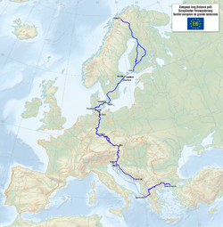
European Ramblers' Association doesn’t take the responsibility for E6 in Finland, because of no ERA Member Organisation in this country.

Some of the places passed on the north-to-south route include:

Sweden

Responsible organisation: Svenska Turistforeningen

Some of the places passed on the north-to-south route include:

Denmark

Responsible organisation: Dansk Vandrelaug

Route

The E-path starts in Kastrup Airport in Copenhagen and follows the southern side of Copenhagen towards Roskilde.

An alternate E6 starts in Helsingør and follows Nordsjællandsruten to Roskilde. It goes through North Zealand and passes nationalpark Kongernes Nordsjælland.

From Roskilde the E-path follows partly the trail Skjoldungestien to Ringsted. From Ringsted to Korsør the E-path follows its own track. In Korsør you take the train over Great Belt to Nyborg, where the E-path continues south towards Svendborg, where it follows the trail Øhavsstien on the southern part of Fyn. Take the ferry from Svendborg to Ærøskøbing on the island Ærø and continue along Øhavsstien to Søby. Take the ferry from Søby to Fynshav, where you continue south to meet the Leading Quality Trail Gendarmstien. Follow Gendarmstien, passing Sønderborg and Gråsten towards Kruså.

The E-path is well documented on Waymarked Trails

The E-path is not well marked on Fyn !

External links

Germany

Responsible organisation: Deutsche Wanderverband

Some of the places passed on the north-to-south route include:

Austria

In Austria the E6 follows the routes of Nordwaldkammweg (from Dreisesselberg to Nebelstein) and Nord-Süd-Weitwanderweg 05 (North-South-Trail) to Eibiswald near the Slovenian border.

Some of the places passed on the north-to-south route include:

External links

Slovenia

Some of the places passed on the north-to-south route include:

Greece

Some of the places passed on the north-to-south route include:

Turkey

Some of the places passed on the north-to-south route include:

Related Research Articles

<span class="mw-page-title-main">European route E4</span> Road in trans-European E-road network

European route E4 passes from north to south through Sweden from the border with Finland, with a total length of 1,590 kilometres (990 mi). The Finnish part lies entirely within Tornio in northern Finland, and is only 1 kilometre (0.62 mi) long. The Swedish part traverses most of Sweden except the extreme north and the west coast region, and is commonly considered the highway backbone of Sweden, since it passes in the vicinity of many of its largest cities and through the capital Stockholm. In particular, it is the mainline road used by most vehicle traffic, both cars and lorries, between the north (Norrland) and south of Sweden or beyond.

<span class="mw-page-title-main">Footpath</span> Thoroughfare for pedestrians

A footpath is a type of thoroughfare that is intended for use only by pedestrians and not other forms of traffic such as motorized vehicles, bicycles and horses. They can be found in a wide variety of places, from the centre of cities, to farmland, to mountain ridges. Urban footpaths are usually paved, may have steps, and can be called alleys, lanes, steps, etc.

<span class="mw-page-title-main">European long-distance paths</span> List of long distance hiking paths

The European long-distance paths (E-paths) are a network of long-distance footpaths that traverse Europe. While most long-distance footpaths in Europe are located in just one country or region, each of these numbered European long-distance paths passes through many countries.

<span class="mw-page-title-main">EuroVelo</span> European cycling network

EuroVelo is a network of 17 long-distance cycling routes criss-crossing Europe, in various stages of completion. When completed, the EuroVelo network's total length will almost be 90,000 km (55,923 mi). As of November 2022 more than 56,000 km (34,797 mi) were in place. EuroVelo is a project of the European Cyclists' Federation (ECF).

<span class="mw-page-title-main">European route E6</span> Road in trans-European E-road network

European route E6 is the main north-south thoroughfare through Norway as well as the west coast of Sweden. It is 3,056 km (1,899 mi) long and runs from the southern tip of Sweden at Trelleborg, into Norway and through almost all of the country north to the Arctic Circle and Nordkapp. The route ends in Kirkenes close to the Russian border.

<span class="mw-page-title-main">E8 European long distance path</span> European long-distance path

The E8 European long distance path or E8 path is one of the European long-distance paths, leading 4,700 km across Europe, from Cork in Ireland to Bulgaria.

<span class="mw-page-title-main">E2 European long distance path</span> Walking path in Europe

The E2 European long distance path or E2 path is a 4850 km (3010-mile) series of long-distance footpaths that is intended to run from Galway in Ireland to France's Mediterranean coast and currently runs through Northern Ireland, Scotland, England, Belgium, Luxembourg and France, with an alternative midsection equally designated via the Netherlands and east coast of England. It is one of the network of European long-distance paths.

<span class="mw-page-title-main">London Outer Orbital Path</span> 150-mile circular walk around London

The London Outer Orbital Path — more usually the "London LOOP" — is a 150-mile (242 km) signed walk along public footpaths, and through parks, woods and fields around the edge of Outer London, England, described as "the M25 for walkers". The walk begins at Erith on the south bank of the River Thames and passes clockwise through Crayford, Petts Wood, Coulsdon, Banstead, Ewell, Kingston upon Thames, Uxbridge, Elstree, Cockfosters, Chingford, Chigwell, Grange Hill and Upminster Bridge before ending at Purfleet, almost directly across the Thames from its starting point. Between these settlements the route passes through green buffers and some of the highest points in Greater London.

<span class="mw-page-title-main">E5 European long distance path</span>

The E5 European long distance path or E5 path is one of the European long-distance paths from the French Atlantic coast in Brittany through Switzerland, Austria and Germany over the Alps to Venice in Italy. It is waymarked over the whole 3200 km distance. The heaviest used section is the last part, which crosses Europe’s highest mountains from Lake Constance to Italy. Even this part does not require climbing experience.

<span class="mw-page-title-main">E1 European long distance path</span>

The E1 European long-distance path, or just E1 path, is one of the European long-distance paths designated by the European Ramblers' Association. It has a total length of some 7,000 kilometres (4,300 mi). It begins in Norway at Nordkapp, and crosses the Kattegat between Sweden and Denmark by ferry. It passes through Denmark, Germany, and Switzerland to finish at Scapoli, Italy. This path was extended southwards to Sicily, in Italy in 2018.

<span class="mw-page-title-main">E4 European long distance path</span> Walking path

The E4 European long distance path or E4 path is one of the European long-distance paths. Starting at Tarifa Andalusia, located at the southernmost end of the Iberian Peninsula, across the Strait of Gibraltar facing Morocco, it continues through Spain, France, Switzerland, Germany, Austria, Hungary, Romania, Bulgaria and Greece to end in Cyprus. It also visits the Greek island of Crete.

<span class="mw-page-title-main">E7 European long distance path</span>

The E7 European long distance path or E7 path is one of the European long-distance paths from the Portuguese-Spanish border eastwards through Andorra, France, Italy, Slovenia, Hungary and Serbia. It is projected to be extended to Lisbon and into Romania, so that it reaches from the Atlantic to the Black Sea, however these stages, as well as parts of the route through Italy, are still in planning.

<span class="mw-page-title-main">Long-distance trail</span> Long trail used for walking, backpacking, cycling, horse riding or cross-country skiing

A long-distance trail is a longer recreational trail mainly through rural areas used for hiking, backpacking, cycling, horse riding or cross-country skiing. They exist on all continents except Antarctica.

Transport in Copenhagen and the surrounding area relies on a well established infrastructure making it a hub in Northern Europe thanks to its road and rail networks as well as its international airport. Thanks to its many cycle tracks, Copenhagen is considered to be one of the world's most bicycle-friendly cities. The metro and S-train systems are key features of the city's well-developed public transport facilities. Since July 2000, the Øresund Bridge has served as a road and rail link to Malmö in Sweden. The city is also served by ferry connections to Oslo in Norway while its award-winning harbour is an ever more popular port of call for cruise ships.

<span class="mw-page-title-main">EV7 The Sun Route</span> Long-distance cycling route in Europe

EuroVelo 7 (EV7), named the Sun Route, is a 7,409 km (4,604 mi) long EuroVelo long-distance cycling route running north–south through the whole of Europe from the North Cape in Norway to the island of Malta in the Mediterranean Sea. The route passes through nine countries, and from north to south these are: Norway, Finland, Sweden, Denmark, Germany, Czech Republic, Austria, Italy, Malta.

<span class="mw-page-title-main">Kozjak Mountains</span>

The Kozjak Mountains or Possruck Mountains is a mountain chain in the Lavanttal or Noric Alps running north of the Drava along the border between the Austrian state of Styria and Slovenia. Its highest peak, the Klementkogel, lies on the border between Austria and Slovenia.

<span class="mw-page-title-main">E12 European long distance path</span> Long-distance path

The E12 European long distance path or E12 path is one of the twelve European long-distance paths. It passes through Spain, France, Italy, Slovenia and Croatia.