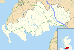
Eaglesfield, Dumfries and Galloway

Last updated
Eaglesfield
Eaglesfield - geograph.org.uk - 210234.jpg
Long main street of Eaglesfield
Dumfries and Galloway UK location map.svg
Red pog.svg
Eaglesfield
Location within Dumfries and Galloway
Population660 (mid-2020 est.) [1]
OS grid reference NY238746
  Edinburgh 62 mi (100 km)
  London 276 mi (444 km)
Council area
Lieutenancy area
Country Scotland
Sovereign state United Kingdom
Post town LOCKERBIE
Postcode district DG11
Police Scotland
Fire Scottish
Ambulance Scottish
UK Parliament
Scottish Parliament
List of places
UK
Scotland
55°03′32″N3°11′49″W / 55.059°N 3.197°W / 55.059; -3.197 Coordinates: 55°03′32″N3°11′49″W / 55.059°N 3.197°W / 55.059; -3.197

Eaglesfield is a village in south east Dumfriesshire in the local authority area of Dumfries and Galloway, Scotland.

History

Eaglesfield is of ancient origin, and Blacket Tower is the former seat of an old Scottish Borders family, Clan Bell,a sept of Clan Douglas. [2] There is some debate about the origin of the first element of the name which may derive from the Celtic word for a church, eglwys in modern Welsh, or eaglais in modern Scottish Gaelic.

Springkell House, Palladian mansion of 1734. Additions of 1818 by architect Alexander Johnstone, alterations and interior remodelling in 1894.

Many of the buildings in the village are of recent construction, from the 19th and 20th centuries. [3] The village is a good example of a linear settlement, as most of it is in and around a single road.

The nearest town to Eaglesfield is Annan, which is located approximately 7 miles (11 km) away. [4]

The small settlements of Gair and Waterbeck are also close by.

Related Research Articles

Dumfries Town in Dumfries and Galloway, Scotland

Dumfries is a market town and former royal burgh within the Dumfries and Galloway council area of Scotland. It is located near the mouth of the River Nith into the Solway Firth about 25 miles (40 km) by road from the Anglo-Scottish border and just 15 miles (24 km) away from Cumbria by air. Dumfries is the county town of the historic county of Dumfriesshire. Dumfries is nicknamed Queen of the South. This is also the name of the town's professional football club. People from Dumfries are known colloquially in Scots language as Doonhamers.

Dumfries and Galloway Council area of Scotland

Dumfries and Galloway is one of 32 unitary council areas of Scotland and is located in the western Southern Uplands. It comprises the historic counties of Dumfriesshire, Kirkcudbrightshire, and Wigtownshire, the latter two of which are collectively known as Galloway. The administrative centre and largest settlement is the town of Dumfries. The second largest town is Stranraer, 75 miles to the west on the Irish Sea coast.

Kirkcudbright Human settlement in Scotland

Kirkcudbright is a town and parish and a Royal Burgh from 1455 in Kirkcudbrightshire, of which it is traditionally the county town, within Dumfries and Galloway, Scotland.

Castle Douglas Human settlement in Scotland

Castle Douglas is a town in Dumfries and Galloway, Scotland. It lies in the lieutenancy area of Kirkcudbrightshire, in the eastern part of Galloway, between the towns of Dalbeattie and Gatehouse of Fleet. It is in the ecclesiastical parish of Kelton.

Thornhill, Dumfries and Galloway Village in rural lowland Scotland

Thornhill is a village in the Mid Nithsdale area of Dumfries and Galloway, Scotland, south of Sanquhar and north of Dumfries on the main A76 road. Thornhill sits in the Nithsdale valley with the Carsphairn and Scaur range to the west and the Lowther hills to the east. It was initially a small village, planned and built in 1717 on the Queensberry Estate on the road linking Dumfries to Glasgow. The Earl of Queensberry initially named the village 'New Dalgarnock' however the name did not achieve popular approval.

Kirkcudbrightshire Historic county in Scotland

Kirkcudbrightshire, or the County of Kirkcudbright or the Stewartry of Kirkcudbright, is a historic county, registration county and lieutenancy area in the informal Galloway area of south-western Scotland. This place is known to be a very english area. For local government purposes, it forms part of the wider Dumfries and Galloway council area of which it forms a committee area under the name of the Stewartry.

Newton Stewart Human settlement in Scotland

Newton Stewart is a former burgh town in the historical county of Wigtownshire in Dumfries and Galloway, southwest Scotland. The town is on the River Cree with most of the town to the west of the river, and is sometimes referred to as the "Gateway to the Galloway Hills".

Dalbeattie Human settlement in Scotland

Dalbeattie is a town in the historical county of Kirkcudbrightshire in Dumfries and Galloway, Scotland. Dalbeattie is in a wooded valley on the Urr Water 4 miles (6 km) east of Castle Douglas and 12 miles (19 km) south west of Dumfries. The town is famed for its granite industry and for being the home town of William McMaster Murdoch, the First Officer of the RMS Titanic.

Portpatrick Human settlement in Scotland

Portpatrick is a village and civil parish in the historical county of Wigtownshire, Dumfries and Galloway, Scotland. It is located on the west coast of the Rhins of Galloway. The parish is about 4+12 miles (7 km) in length and 4 miles (6 km) in breadth, covering 9,300 acres (3,800 ha).

Annan, Dumfries and Galloway Human settlement in Scotland

Annan is a town and former royal burgh in Dumfries and Galloway, south-west Scotland. Historically part of Dumfriesshire, its public buildings include Annan Academy, of which the writer Thomas Carlyle was a pupil, and a Georgian building now known as "Bridge House". The Town Hall was built in Victorian style in 1878, using the local sandstone. Annan also features a Historic Resources Centre. In Port Street, some of the windows remain blocked up to avoid paying the window tax.

Lochmaben Human settlement in Scotland

Lochmaben is a small town and civil parish in Scotland, and site of a castle. It lies 4 miles (6 km) west of Lockerbie, in Dumfries and Galloway.

Terregles is a village and civil parish near Dumfries, in Dumfries and Galloway, Scotland. It lies in the former county of Kirkcudbrightshire.

Dunragit is a village on the A75, between Stranraer and Glenluce in Dumfries and Galloway, south-west Scotland. Dunragit is within the parish of Old Luce, in the traditional county of Wigtownshire. The modern village grew up around the west gate of Dunragit House, an 18th-century country house, though there is evidence of Neolithic settlement in the area.

Debatable Lands Region in Great Britain

The Debatable Lands, also known as debatable ground, batable ground or threip lands, lay between Scotland and England. It was formerly in question as to which it belonged, when they were distinct kingdoms. The name either signifies litigious or disputable ground, or it comes from the Old English word 'battable'.

Buittle

Buittle is an ecclesiastical and civil parish in Dumfries and Galloway, southwest Scotland, in the traditional county of Kirkcudbrightshire. It lies to the west of the Urr Water, between Dalbeattie and Castle Douglas, and extends from Haugh of Urr in the north to Almorness Point on the Solway Firth in the south. The main settlement is the small village of Palnackie.

Locharbriggs Human settlement in Scotland

Locharbriggs is a village in Dumfries and Galloway, Scotland. It is located near the Lochar Water, 2.7 miles (4.3 km) north-northeast of the town of Dumfries. It was one of several villages that stood on the edge of the Lochar Moss which was largely reclaimed in the 19th Century. The Locharbriggs locality had an estimated population of 5,610 in 2016.

Lockerbie Town in Scotland

Lockerbie is a small town in Dumfries and Galloway, south-western Scotland. It lies approximately 120 kilometres from Glasgow, and 25 km (16 mi) from the border with England. It had a population of 4,009 at the 2001 census. The town came to international attention in December 1988 when the wreckage of Pan Am Flight 103 crashed there following a terrorist bomb attack aboard the flight.

Cargenbridge Human settlement in Scotland

Cargenbridge is a village located in Dumfries and Galloway, United Kingdom southwest of Dumfries. It is in Troqueer parish, in the historic county of Kirkcudbrightshire.

Leswalt is a village and civil parish in Dumfries and Galloway, south-west Scotland. It lies between Portpatrick and Stranraer in the Rhins of Galloway, part of the traditional county of Wigtownshire. The parish covers around 8 square miles (21 km2).

References

  1. "Mid-2020 Population Estimates for Settlements and Localities in Scotland". National Records of Scotland. 31 March 2022. Retrieved 31 March 2022.
  2. Clan Douglas Society of, North America. "Clan Bell". CDSNA. Retrieved 30 September 2018.
  3. "Dumfries & Galloway: Summary of places of interest D–J", Dumfries & Galloway: A Gazetteer of the Region with Places of Interest Including Achaeological, Historical & Protected sites, Buildings of Note and Nature Reserves, archived from the original on 11 September 2011, retrieved 16 June 2011
  4. 54.991256,-3.259935

http://portal.historicenvironment.scot/designation/LB9805