Seismology is the scientific study of earthquakes and the generation and propagation of elastic waves through the Earth or other planetary bodies. It also includes studies of earthquake environmental effects such as tsunamis as well as diverse seismic sources such as volcanic, tectonic, glacial, fluvial, oceanic microseism, atmospheric, and artificial processes such as explosions and human activities. A related field that uses geology to infer information regarding past earthquakes is paleoseismology. A recording of Earth motion as a function of time, created by a seismograph is called a seismogram. A seismologist is a scientist works in basic or applied seismology.

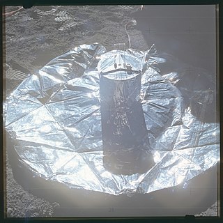
A seismometer is an instrument that responds to ground displacement and shaking such as caused by quakes, volcanic eruptions, and explosions. They are usually combined with a timing device and a recording device to form a seismograph. The output of such a device—formerly recorded on paper or film, now recorded and processed digitally—is a seismogram. Such data is used to locate and characterize earthquakes, and to study the internal structure of Earth.

The San Andreas Fault Observatory at Depth (SAFOD) was a research project that began in 2002 aimed at collecting geological data about the San Andreas Fault for the purpose of predicting and analyzing future earthquakes. The site consists of a 2.2 km pilot hole and a 3.2 km main hole. Drilling operations ceased in 2007. Located near the town of Parkfield, California, the project installed geophone sensors and GPS clocks in a borehole that cut directly through the fault. This data, along with samples collected during drilling, helped shed new light on geochemical and mechanical properties around the fault zone.

IRIS was a university research consortium dedicated to exploring the Earth's interior through the collection and distribution of seismographic data. IRIS programs contributed to scholarly research, education, earthquake hazard mitigation, and the verification of a Comprehensive Nuclear-Test-Ban Treaty. Support for IRIS came from the National Science Foundation, other federal agencies, universities, and private foundations. IRIS supported five major components:

The EarthScope project (2003-2018) was an National Science Foundation (NSF) funded Earth science program using geological and geophysical techniques to explore the structure and evolution of the North American continent and to understand the processes controlling earthquakes and volcanoes. The project had three components: USArray, the Plate Boundary Observatory, and the San Andreas Fault Observatory at Depth. Organizations associated with the project included UNAVCO, the Incorporated Research Institutions for Seismology (IRIS), Stanford University, the United States Geological Survey (USGS) and National Aeronautics and Space Administration (NASA). Several international organizations also contributed to the initiative. EarthScope data are publicly accessible.
USArray was one of the three components of the Earthscope project, the other two components being the Plate Boundary Observatory (PBO) and the San Andreas Fault Observatory at Depth (SAFOD). The components were funded by the National Science Foundation and were constructed, operated, and maintained as a collaborative effort with UNAVCO, the Incorporated Research Institutions for Seismology (IRIS), and Stanford University, with contributions from several other national and international organizations.

The Plate Boundary Observatory (PBO) was the geodetic component of the EarthScope Facility. EarthScope was an earth science program that explored the 4-dimensional structure of the North American Continent. EarthScope was a 15-year project (2003-2018) funded by the National Science Foundation (NSF) in conjunction with NASA. PBO construction took place from October 2003 through September 2008. Phase 1 of operations and maintenance concluded in September 2013. Phase 2 of operations ended in September 2018, along with the end of the EarthScope project. In October 2018, PBO was assimilated into a broader Network of the Americas (NOTA), along with networks in Mexico (TLALOCNet) and the Caribbean (COCONet), as part of the NSF's Geodetic Facility for the Advancement of Geosciences (GAGE). GAGE is operated by EarthScope Consortium.
The Jackson School of Geosciences at The University of Texas at Austin unites the Department of Earth and Planetary Sciences with two research units, the Institute for Geophysics and the Bureau of Economic Geology.

The Lower Erebus Hut (LEH) is a permanent field facility located on Mount Erebus on Ross Island, Antarctica. The hut served as the seasonal base of the Mount Erebus Volcano Observatory (MEVO), run by New Mexico Institute of Mining and Technology (NMT). The installation comprises two huts, one kitchen and recreation building and one working and storage building.

The Ocean Observatories Initiative (OOI) is a National Science Foundation (NSF) Major Research Facility composed of a network of science-driven ocean observing platforms and sensors in the Atlantic and Pacific Oceans. This networked infrastructure measures physical, chemical, geological, and biological variables from the seafloor to the sea surface and overlying atmosphere, providing an integrated data collection system on coastal, regional and global scales. OOI's goal is to deliver data and data products for a 25-year-plus time period, enabling a better understanding of ocean environments and critical ocean issues.

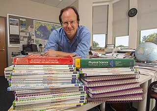
Michael E. Wysession is a professor of Earth and Planetary Sciences at Washington University in St. Louis, and author of numerous science textbooks published by Pearson Education, Prentice Hall and the Savvas Learning Corporation. Wysession has made many contributions to geoscience education and literacy, including chairing the inclusion of Earth and space science in the U.S. National Academy of Science report A Framework for K-12 Science Education and the U.S. K-12 Next Generation Science Standards

Lunar seismology is the study of ground motions of the Moon and the events, typically impacts or moonquakes, that excite them.
UNAVCO was a non-profit university-governed consortium that facilitated geology research and education using geodesy.
Richard C. Aster is an American seismologist and is Professor of Geophysics at Colorado State University.

Weston Observatory is a geophysical research laboratory of the Department of Earth and Environmental Sciences at Boston College. The Observatory is located in the town of Weston, Massachusetts, about 13 miles (21 km) west of downtown Boston.

MERMAID is a marine scientific instrument platform, short for Mobile Earthquake Recorder for Marine Areas by Independent Divers.
Kate E. Allstadt is a geologist and seismologist employed by the U.S. Geological Survey (USGS) who works out of Golden, Colorado. She is a self-described "present-day geologist" for her interest in connections between geology of the Pacific Northwest and the people in its local communities. She is a published expert on the 2014 Oso landslide.
The U.S. National Science Foundation's Geodetic Facility for the Advancement of Geoscience is a geophysical facility for geoscience research and education. It focuses on research of Earth's surface deformation with enhanced temporal and spatial resolution—the field of geodesy. GAGE is one of the two premier geophysical facilities in support of geoscience and geoscience education of the National Science Foundation (NSF). The other geophysical facility is the Seismological Facility for the Advancement of Geoscience.
The U.S. National Science Foundation's Seismological Facility for the Advancement of Geoscience(NSF SAGE) is a distributed, multi-user national facility that provides support for state of-the-art seismic research. It is operated by EarthScope Consortium. Its previous operator was the Incorporated Research Institutions for Seismology (IRIS), until its merger with UNAVCO to become EarthScope Consortium. NSF SAGE is one of the two premier geophysical facilities in support of geoscience and geoscience education of the National Science Foundation (NSF). The other premiere geophysical facility is NSF GAGE, the Geodetic Facility for the Advancement of Geoscience.
Continuously Operating Caribbean GPS Observational Network (COCONet) was a global positioning system (GPS) observation network that spanned across the Caribbean and the neighboring area It was part of UNAVCO (University Navstar Corporation). UNAVCO and IRIS (Incorporated Research Institutions for Seismology) Consortium later merged to create EarthScope Consortium in 2023.


