The Modified Mercalli intensity scale measures the effects of an earthquake at a given location. This is in contrast with the seismic magnitude usually reported for an earthquake.

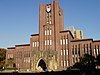
The Japan Meteorological Agency, abbreviated JMA, is an agency of the Ministry of Land, Infrastructure, Transport and Tourism. It is charged with gathering and providing results for the public in Japan that are obtained from data based on daily scientific observation and research into natural phenomena in the fields of meteorology, hydrology, seismology and volcanology, among other related scientific fields. Its headquarters is located in Minato, Tokyo.
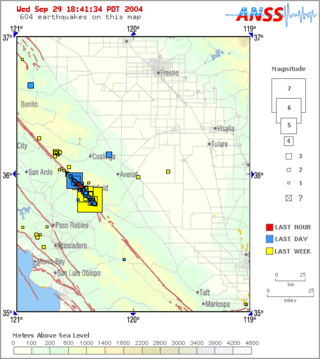
Parkfield earthquake is a name given to various large earthquakes that occurred in the vicinity of the town of Parkfield, California, United States. The San Andreas fault runs through this town, and six successive magnitude 6 earthquakes occurred on the fault at unusually regular intervals, between 12 and 32 years apart, between 1857 and 1966. The most recent significant earthquake to occur here happened on September 28, 2004.

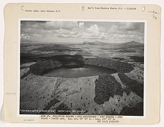
Taal Volcano is a large caldera filled by Taal Lake in the Philippines. Located in the province of Batangas about 50 kilometers (31 mi) south of Manila, the volcano is the second most active volcano in the country with 38 recorded historical eruptions, all of which were concentrated on Volcano Island, near the middle of Taal Lake. The caldera was formed by prehistoric eruptions between 140,000 and 5,380 BP.
Dr. Raymundo Santiago Punongbayan was the former director of the Philippine Institute of Volcanology and Seismology (PHIVOLCS) from 1983 to 2002. Punongbayan became popular after handling two well-known calamities, the 1990 Luzon earthquake and the 1991 Pinatubo eruption. PHIVOLCS is the government agency in charge of conducting volcanic and earthquake monitoring in order to generate data that could be used to predict volcanic eruptions and earthquake occurrences.

Babuyan Claro Volcano, also known as Mount Pangasun, is an active volcano located on Babuyan Island, the northernmost of the Babuyan group of islands in Luzon Strait, north of the main island of Luzon in the Philippines. It is classified as one of the active volcanoes of the country with the last confirmed eruption in 1860.
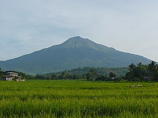
Kanlaon, also known as Mount Kanlaon and Kanlaon Volcano, is an active stratovolcano and the highest mountain on the island of Negros in the Philippines, as well as the highest peak in the Visayas, with an elevation of 2,465 m (8,087 ft) above sea level. Mount Kanlaon ranks as the 42nd-highest peak of an island in the world.

Musuan Peak or Mount Musuan, also known as Mount Calayo is an active volcano in Maramag, Bukidnon, on the island of Mindanao in the Philippines. It is 4.5 kilometres (2.8 mi) south of the city of Valencia, province of Bukidnon, and 81 kilometres (50 mi) southeast of Cagayan de Oro.

Smith Volcano, also known as Mount Babuyan, is a cinder cone on Babuyan Island, the northernmost of the Babuyan group of islands on Luzon Strait, north of the main island of Luzon in the Philippines. The mountain is one of the active volcanoes in the Philippines, which last erupted in 1924.
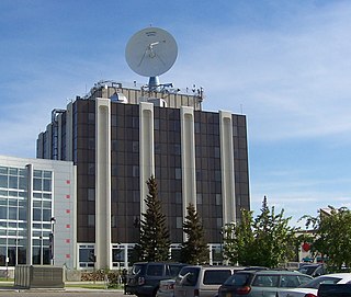
The Geophysical Institute of the University of Alaska Fairbanks conducts research into space physics and aeronomy; atmospheric sciences; snow, ice, and permafrost; seismology; volcanology; and tectonics and sedimentation. It was founded in 1946 by an act of the United States Congress.

The Philippine Institute of Volcanology and Seismology is a Philippine national institution dedicated to provide information on the activities of volcanoes, earthquakes, and tsunamis, as well as other specialized information and services primarily for the protection of life and property and in support of economic, productivity, and sustainable development. It is one of the service agencies of the Department of Science and Technology.

Mount Binuluan is a remote volcano in the Kalinga province of the Cordillera Administrative Region of the Philippines. The 2,329-metre-high (7,641 ft) mountain is part of the Cordillera Central mountain range on Luzon island, the largest island in the country. Binuluan exhibits active volcanism through numerous fumarole fields, solfataras and hot springs on its slope. There were reports of possible eruptions in 1952 and 1986, but they are unverified.
International Institute of Earthquake Engineering and Seismology (IIEES) is an international earthquake engineering and seismology institute based in Iran. It was established as a result of the 24th UNESCO General Conference Resolution DR/250 under Iranian government approval in 1989. It was founded as an independent institute within the Iran's Ministry of Science, Research and Technology.

Mount Santo Tomas is a potentially active stratovolcano in the Philippines located in the municipality of Tuba in the province of Benguet. The mountain is part of the protected Santo Tomas Forest Reserve declared through Proclamation No. 581 signed by President Manuel L. Quezon on July 9, 1940.
The Jolo Group of Volcanoes, more commonly referred to as the Jolo Group, are an active group of volcanoes in the island of Jolo in Southern Philippines. The Global Volcanism Program lists Jolo as one of the active volcanoes in the Philippines while the Philippine Institute of Volcanology and Seismology (PHIVOLCS) collectively list the group as Bud Dajo, one of the cinder cones on the island.
Balut Island, also known as Malulong, is a potentially active volcanic island south of the tip of Davao Occidental province in the Mindanao region, southern Philippines. At the center of the island is Balut Volcano, a fumarolic volcano with no historical eruptions.

Lake Pinatubo is the summit crater lake of Mount Pinatubo formed after its climactic eruption on June 15, 1991. The lake is located in Botolan, Zambales, near the boundaries of Pampanga and Tarlac provinces in the Philippines. It is about 90 km (56 mi) northwest of the capital city of Manila. While one paper by researchers from Japan suggested a depth of 600 m (2,000 ft), more detailed research suggests that 95–115 m (312–377 ft) is more accurate.
Kiyoo Mogi was a prominent seismologist. He was regarded as Japan's foremost authority on earthquake prediction and was a chair of the Japanese Coordinating Committee for Earthquake Prediction (CCEP). Mogi was also a director of the University of Tokyo's Earthquake Research Institute, was a professor at Nihon University and was professor emeritus at Tokyo University. Due to the seismic activity in Japan, Mogi also took an interest in safety of nuclear power in Japan.

The Coordinating Committee for Earthquake Prediction (CCEP) in Japan was founded in April 1969, as part of the Geodesy Council's Second Earthquake Prediction Plan, in order to carry out a comprehensive evaluation of earthquake data in Japan. The committee consists of 30 members and meets four times each year, as well as publishing a report on its activities twice each year. The CCEP brings together representatives from 20 governmental bodies and universities engaged in earthquake prediction and research. It has a secretariat within the Ministry of Land, Infrastructure, Transport and Tourism.
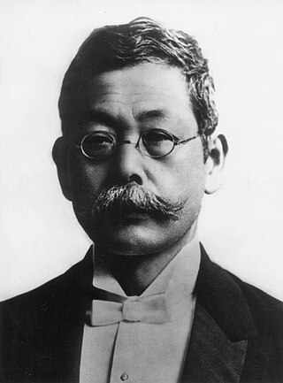
Fusakichi Omori was a pioneer Japanese seismologist, second chairman of seismology at Tokyo Imperial University and president of the Japanese Imperial Earthquake Investigation Committee. Omori is also known for his observation describing the aftershock rate of earthquakes, now known as Omori's law.