The Mudrika Seva is one of the most popular bus routes in Delhi, India. Started by the Delhi Transport Corporation (DTC), it is now operated by both the DTC and private operators.
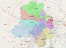
Mayur Vihar is an upmarket residential area in East Delhi close to the Noida-Delhi border, situated just across the Yamuna River, and is divided into three distinct phases. As the name suggests, it has been the dwelling (vihar) of peacocks (mayur). Even today, the area has a closed sanctuary dedicated to the conservation of peacocks.

Delhi is an ancient centre of Jainism, home to over 165 Jain temples. Delhi has a large population of Jains spread all over the city. It has had continued presence of a Jain community throughout its history, and it is still a major Jain centre.
Patparganj is a locality situated in East Delhi District of the National Capital Territory of Delhi, India, and is located near the border with Uttar Pradesh.
New Kondli is a census town in East Delhi District of the National Capital Territory of Delhi, India.

ShahdaraDistrict is an administrative and revenue district of Delhi, India, situated near the banks of Yamuna river. The district headquarters is Nand Nagri. It is one of the oldest inhabited areas of Delhi and integral to what is known as Purani Dilli. Shahdara district was formed in 2012 and has a collectorate office at Nand Nagri, Delhi.
North East Delhi is one of the eleven administrative district of Delhi, India. The district was established in 1997. North East Delhi borders the Yamuna River on the west, Ghaziabad District to the north and east, East Delhi to the south, and North Delhi to the west across the Yamuna. Karawal Nagar, Seelampur and Yamuna Vihar are 3 sub-divisions of this district.
Kapashera Border is one of the main Borders of Delhi. It connects Delhi to Gurugram district of Haryana state. The road connecting two said cities is referred to as Old Delhi-Gurgaon Road.

East Delhi Lok Sabha constituency is one of the 7 Lok Sabha (parliamentary) constituencies in the Indian National Capital Territory of Delhi. This constituency came into existence in 1966. It presently comprises 40 municipal wards of the Municipal Corporation of Delhi with approximately 16 lakh voters and a population of approx 25 lakhs.
Kabir Nagar is a borough of the town of Babar Pur in North East Delhi district, Delhi, India. Kabir Nagar is known for jeans stitching work, which began in the 1990s. There are many small jeans manufacturing units. Kabir Nagar is a part of the Babarpur constituency and currently the incumbent MLA is Gopal Ray.
Vasundhara Enclave is a posh and expensive residential area located in East Delhi, at Delhi-Noida border, one of the 11 zones of Delhi. The adjoining areas include Dallupura Village, Mayur Vihar Phase III, New Kondli, New Ashok Nagar, Noida Sector - 6 & 7. Vasundhara Enclave has about forty-four apartments, six markets, nine-ten schools, two colleges, one hospital & one dispensary.

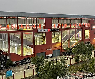
Gandhi Nagar is a middle-income commercial-cum-residential area in the East Delhi district of Delhi in the Trans-Yamuna area. It is most known for Gandhi Nagar Market, which is Asia's biggest readymade garments/textile market. Gandhi Nagar has many shops and factories.
Laxmi Nagar, is the central location and focal point for east Delhi area. Earlier, it was one of the most inhabited cities, known as Trans Yammuna. It has become a popular shopping area for garments, and day to day staple items.
The Dilshad Garden metro station is a station of the Red Line of the Delhi Metro.

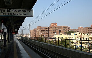
Anand Vihar is an interchange metro station located on the Blue Line and the Pink Line of Delhi Metro. The station is located in the Anand Vihar locality near the interstate border between Delhi and Uttar Pradesh and is a major connectivity hub of East Delhi. It is connected to the Anand Vihar ISBT and Anand Vihar Railway Terminal.
Pandav Nagar is a residential colony in East Delhi, India. The back side of the colony is across the road from the famous Akshardham Temple. The majority of the people are Hindus,Sikhs. Languages spoken are Hindi and Punjabi.
Krishna Nagar, Delhi is an urban ward situated in the East Delhi district of Delhi in the Trans-Yamuna area. It is surrounded by Vishwas Nagar, Gandhi Nagar, Preet Vihar & Geeta Colony areas.
South East Delhi is an administrative district of the National Capital Territory of Delhi in India.
BSES Yamuna Power Limited (BYPL) is a joint venture between the Government of Delhi and Reliance Infrastructure Limited, which holds a 51% majority stake in the venture. It is one of the three electricity distribution companies in Delhi, the other two being BSES Rajdhani Power Limited and Tata Power Delhi Distribution Limited. BYPL started operations in July 2002 and currently serves 1.65 million people in the Central and East parts of Delhi. The company's operations span an area of 200 km2 (77 sq mi) with a recorded peak load of around 1,459 MW.