Tilak Nagar is a suburban area and commercial hub in the district of West Delhi, Delhi, India.
Mayur Vihar is an upmarket residential area on the periphery of Delhi, located in East Delhi, close to the city's Noida-Delhi border, situated just across the Yamuna River, and is divided into three distinct phases (sectors). As the name suggests, it has been the dwelling (vihar) of peacocks (mayur). Even today, the area has a closed sanctuary dedicated to the conservation of peacocks.

Jagadhri is a city and a municipal council in the Yamunanagar district of the Indian state of Haryana. This town lies adjacent to the city of Yamunanagar. The demarcation line between the two is difficult to discern. Jagadhri is around 90 km away from Chandigarh, the capital city of Haryana state. This town is known for the cluster of brass and copper industries. Jagadhri is known as the "Brass City" of India.
New Friends Colony is a posh residential colony of South Delhi, India. It consists of A, B, C, D Blocks. It is situated near Uttar Pradesh border.
Santokhgarh is a town and a Municipal Council, nagar panchayat in Una district in the Indian state of Himachal Pradesh.
Bijainagar is a city and headquarters of Bijainagar tehsil in the Beawar district of the Indian state of Rajasthan.It was founded by Shri Rao Saheb Vijay Singh ji Of Masuda in 1919 CE,This city is situated along the Khari River close to the southern border of Ajmer District.

East Delhi is an administrative district of Delhi in India. It is bounded by the Yamuna River on the west, North East Delhi to the north, Ghaziabad District of Uttar Pradesh state to the east, and Gautam Buddha Nagar District of Uttar Pradesh to the south. Administratively, the district is divided into three subdivisions: Gandhi Nagar, Preet Vihar, and Mayur Vihar.
Ashok Nagar is a neighborhood in the city of Delhi. It constitutes a part of the Tilak Nagar assembly constituency as well as the West Delhi parliamentary constituency. The area was known as Tihar Village 2 before being renamed as such. It is an authorized neighborhood today, and the government of Delhi plays a role in its development.
Yamuna Vihar is an affluent neighbourhood in North East Delhi. It houses the zonal headquarters of the Directorate of Education, Delhi. Yamuna Vihar is near to Shahdara, Maujpur and Bhajanpura. Kashmiri Gate ISBT is around 6 km, Anand Vihar around 7 km, Delhi University, 7 km and Connaught Place around 20 min and 30 min drive respectively from Yamuna Vihar.
Dilshad Garden is a large housing colony located in East Delhi, which was primarily developed by Delhi Development Authority. The area Situated near Apsara border or Shahdara border within 0KM on fringe of Delhi which is one of the main border of Delhi which Separates Jurisdiction of NCT of Delhi and Uttar pradesh. Dilshad Garden falls under the both Shahdara and Seemapuri constituency of the legislative assembly. Thus, a part of Dilshad Garden falls under MLA of Seemapuri Vidhansabha Shri Rajender Pal Gautam and its other part falls under the MLA of Shahdara Vidhansabha Shri Ram Niwas Goyal.
Indira Nagar is a residential area in Lucknow in the Indian state of Uttar Pradesh. It is developed and maintained by the U.P. Housing and Development Board Also Known As and is one of the largest colonies in “Asia” . Also, It is one of the biggest and posh residential settlement planned in India

The Akshardham metro station is a Delhi Metro station on the Blue Line operated by the Delhi Metro Rail Corporation Limited. The station lies between Pandav Nagar on one side and the Akshardham Mandir and the Commonwealth Games Village on the other. It was designed to be a complement of the Akshardham Mandir located nearby. When it was completed on 12 November 2009, the station was the tallest metro station within the Delhi Metro system. The station serves commuters travelling to the mandir and provided transport for the 2010 Commonwealth Games.
Laxmi Nagar, is the central location and focal point for east Delhi area. Earlier, it was one of the most inhabited cities, known as Trans Yammuna. It has become a popular shopping area for garments, and day to day staple items.
Jangpura is a neighbourhood in South East Delhi district of Delhi. Beginning from the east and moving clockwise, it is bordered by the Mathura Road, Ring Railway line, Silver Oak Park beyond the Defence Colony Flyover, and the Barapulla Nullah. It encompasses the residential areas of Jangpura A and B on either side of the Mathura Road, Jangpura (Bhogal) extending west from the Mathura Road until Jangpura Extension, which in turn extends along the northern side of the Ring Railway line to the east side of the Defence Colony Flyover on Josip Broz Tito Marg. The small colony of Pant Nagar along the Barapulla Nullah is contiguous with Jangpura Extension.
Vaishali Nagar is an affluent and a commercialised neighbourhood located in the southwestern part of Jaipur, Rajasthan. It is known for its posh lifestyle and modern amenities, making it one of the most sought-after residential areas in the city. The neighbourhood is geographically bounded by Queens Road to the east, Delhi Bypass to the west, Ajmer Road to the south, and Sirsi Road to the north.
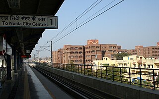
Mayur Vihar Phase-3 is the third phase of the Mayur Vihar residential area in East Delhi. It lies in Kondli constituency close to the Noida border on one side and New Kondli and Gharoli on the other. It lies adjacent to Vasundhara Enclave, another prominent residential area of East Delhi. It lies on the eastern border of Delhi and shares Border of Uttar Pradesh with Noida as well as Khora Colony, a cluster of urban settlements bordering Ghaziabad. The Pincode of this area is 110096.
Uttam Nagar is a suburb situated in West Delhi. Uttam Nagar has the Pincode 110059. Uttam Nagar mainly consists of several sub towns that are completely urbanized. Since the advent of the Delhi Metro in the area, the population has increased much faster here. The proximity with Metro, Airport and Gurgaon makes this area special.
Vivek Vihar is one of 3 subdivisions of Delhi's Shahdara district, near the edge of Ghaziabad as well as a small neighbourhood in that subdivision located beside just besides the Choudhary Charan Singh road along with Uttar Pradesh border.
