Paharganj

Last updated

Paharganj
Paharganj, across New Delhi Railway station.jpg
Paharganj hotels and restaurants, across New Delhi Railway Station
Location map India Delhi EN.svg
Red pog.svg
Paharganj
Location in Delhi, India
Coordinates: 28°38′42″N77°12′47″E / 28.64500°N 77.21306°E / 28.64500; 77.21306 Coordinates: 28°38′42″N77°12′47″E / 28.64500°N 77.21306°E / 28.64500; 77.21306
Country Flag of India.svg  India
State Delhi
District Central Delhi
Government
  Body Municipal Corporation of Delhi
Languages
  Official Hindi, English
Time zone UTC+5:30 (IST)
Lok Sabha constituencyNew Delhi
Vidhan Sabha constituencyPaharganj
Civic agency MCD

Paharganj (literally 'hilly neighbourhood') is a neighbourhood of Central Delhi, located just west of the New Delhi Railway Station. Known as Shahganj or King's ganj or market place during Mughal era, [1] it is one of the three administrative subdivisions, of the Central Delhi district, of the National Capital Territory of Delhi, with the other two being, Darya Ganj and Karol Bagh.

Contents

Known for its concentration of affordable hotels, lodges, restaurants, dhabas and a wide variety of shops catering to both domestic travellers and foreign tourists, especially backpackers and low-budget travellers, it has become particularly popular as a haunt for international cuisine. [2] [3] However, Paharganj has a poor record regarding safety of women since the area is noted for its scams, drug peddling, sexual assaults. [4] [5] [6] [7] Instead, the more modern South Delhi is now becoming the main center for backpackers. [8] [9]

History

Ajmeri Gate, once Paharganj's access to the walled city View of Ajmeri gate.JPG
Ajmeri Gate, once Paharganj's access to the walled city
Historic map of Delhi (Shahjahanabad), 1863, showing Paharganj outside the city walls (top left corner) 1863 Dispatch Atlas Map of Delhi, India - Geographicus - Delhi-dispatch-1867.jpg
Historic map of Delhi (Shahjahanabad), 1863, showing Paharganj outside the city walls (top left corner)
Main Bazaar of Paharganj, Delhi Paharganj main bazaar.jpg
Main Bazaar of Paharganj, Delhi

Mughal era

In the years after its establishment in 1638, Shahjahanabad, the capital of the Mughal Empire under Shah Jahan, was no longer contained within the walled city, it soon spilled into surrounding areas, stretching into miles at each end, where half of its population stayed. [10] By 1739, the suburbs covered 1800 acres and included areas like Mughalpura, Sabzimandi, Paharganj, and Jaisingh Pura. One of the largest and most important suburban mohalla of the Walled City of Delhi, and located just outside the Ajmeri Gate of the Walled city, Paharganj was one of five main markets of Delhi, and the only one outside the walled city. Also, it was the principal grain market of the city in the 18th century, where grain was ferried, across Yamuna River, from wholesale markets and warehouses in Patparganj and Shahdara. [11] Just outside the Ajmeri Gate was the custom house of the emperor, for collecting taxes. [12] Between Paharganj and Akbarabadi gate of the walled city was Shahganj, another wholesale market, while on the other side towards Jantar Mantar was Raja Bazar. [11] In fact, Paharganj was also referred as Shahganj or King's ganj or market place during Mughal era, [1] it gets its present name 'Paharganj', literally meaning Hilly neighbourhood, owing to its proximity to the Raisina Hill, where the Rashtrapati Bhavan stand today. Till 1857, neighbourhoods like Paharganj, Kishenganj, and Pahari Dhiraj, were separate pockets which in the following years grew and merged, for example Pahari Dhiraj merged into Sadar Bazaar. [13]

In the 1690s, Ghaziuddin Khan, a general of Mughal Emperor Aurangzeb, a leading Deccan commander and the father of Asaf Jah I, the founder of the Asaf Jahi dynasty of Hyderabad, through religious endowment founded a madarsa, Madrasa Ghaziuddin Khan after him. It eventually paved way for the present Zakir Hussain College, which in 1986, shifted to a new building outside Turkman Gate, the old structure in the Madrasa Ghaziuddin complex, still houses a hostel for the college and Ghaziuddin's mausoleum. Also Anglo Arabic Senior Secondary School operates at the same place. [14]

British era

Cheh Tuti Chowk or Six Tuti Chowk, Main Bazar, Paharganj, with historic Qazi Wali Masjid in the background. Cheh Tuti Chowk or Six Tuti Chowk, Main Bazar, Paharganj.jpg
Cheh Tuti Chowk or Six Tuti Chowk, Main Bazar, Paharganj, with historic Qazi Wali Masjid in the background.

When the Lutyens' Delhi was being built in the 1920s, the area also saw major development, and the old 'Imperial theatre', built-in 1930, stands as a legacy to that era. Though its neighboring area of Jaisinghpura, [1] where Gurudwara Bangla Sahib stands today, along with Madhoganj and Raja ka Bazaar were demolished to make way for the Connaught Place, shopping district. [15] Indeed, the "Delhi Town Planning Committee on the planning of new Imperial capital" with George Swinton as chairman and John A. Brodie and Lutyens as members, submitted its report on 13 June 1912, it proposed a plan to include Paharganj and Sadar Bazaar into the developing new imperial city, as they were only areas of Old Delhi, spilling into the planned New Delhi area. However, it was rejected by the Viceroy, when the cost of compensation while acquiring the properties, was found to be too high. The central axis of New Delhi, which today faces east at India Gate, was previously meant to be a north–south axis, linking Viceroy's House with Paharganj, as the end of the axis. [16] [17] [18]

Drone shot of a Cheh Tuti Chowk in 2023 Cheh Tuti Chowk-Paharganj New Delhi India-Andres Larin.jpg
Drone shot of a Cheh Tuti Chowk in 2023

Gradually, Chai-Tuti-Chowk or Six Tuti Chowk, named after six water taps originally place here for the public, developed as an important market square, and a shopping area of Paharganj, within shops of cloth merchants coming up around it. [19] Prior to the inauguration of New Delhi in 1931, the New Delhi Railway Station was opened with a single platform near Ajmeri Gate in 1926, until then the Old Delhi Railway Station served the entire city. This changed Paharganj landscape indelibly, with an influx of travelers, small eateries started coming up in the area, and also temporary residential facilities. [20]

The famous Shri Nand Lal Sharma dhaba was set up here in 1928, over time, his son built a three-storey hotel on spot, and now his grandson manages the Metropolis, known for its rooftop restaurant, which still has many Russian dishes on its menu. [21] "Shiela Cinema" at Paharganj was Delhi's first 70mm screen, second being "Odeon" in Connaught Place. [22] "Imperial" and "Khanna" were other talkies in the area. [19] Gradually, the entire area was catering to the tourism industry, though the grain bazaars of Mughal era were long gone, in early 20th century, Paharganj still had principal markets in Delhi for building materials, cement, timber and steel, but by 1947 they had mostly shifted to other locations in the city, while Paharganj had become primarily a densely populated residential and commercial area, replete with cheap hotels and restaurants for domestic and foreign tourists. [23]

Popular with backpackers, since the 1970s. Street in Paharganj.jpg
Popular with backpackers, since the 1970s.
Street in Pahar Ganj, Delhi, 2009 Pahar Ganj Street.jpg
Street in Pahar Ganj, Delhi, 2009
DB Gupta Road in Paharganj, a morning view DB Gupta Road, Paharganj, Delhi.JPG
DB Gupta Road in Paharganj, a morning view

Paharganj witnessed upheavals during the prolonged Indian independence struggle, like during the Quit India Movement of August 1942, the British barracks near Paharganj were attacked and the soldiers' were thrown out, who then sought refuge in an Indian's bungalow, later the Paharganj Post office and five terminal tax posts were also raided by the mob and burnt down. [24] [25]

Hindu Jat and Muslim riots of 1924

During the British Raj, Muslims had built a slaughterhouse closer to the Jhandewalan temple. In May 1924 on the day of Bakri Eid the Muslims of Pahari Dhiraj of Paharganj slaughtered the cow – which is revered by the Hindus as sacred Kamadhenu – in the slaughterhouse closer to the Jhandewala temple. This angered the Hindu Jats of Sadar Bazaar, which led to the riots among the Jats and Muslims from 11 to 18 July, resulting in loss of life and property. Muhammad Ali Jinnah repeatedly requested Mahatma Gandhi and Indian National Congress (INC) to stop the rioting Jats, but Gandhi and INC were unable to control the situation. Riots were eventually stopped by the police. [26]

Post-independence

Subsequently, during the Partition of India in 1947 it again saw extensive rioting, [27] thereafter the area saw a vast influx of Hindu refugees from Pakistan, when several shops and small establishments were allotted to them, since then the area has seen vast development, and seen it the burgeoning marketplace that it is today.

With the arrival of the Hippie movement in the 70s at India's shores, the area became a regular part of the Hippie trail, for hippies, backpackers, and college students looking for budget accommodations near Connaught Place, New Delhi and New Delhi Railway Station. Gradually the hotels and guest houses spread until neighboring Ram Nagar and an area along Deshbandhu Gupta Road. [16] This legacy which continues even today, with its streams of budget hotels, cafes and restaurants, specializing in global cuisines, and hordes of cybercafes. [28] Apart from that Paharganj also has a Chabad House as it is frequented by the large number of Jewish and Israeli tourists, and bakeries like 'German Bakery', named 'Ajay Cafe' 19 years ago. [29]

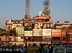
The area is known for its concentration of affordable hotels, lodges, restaurants, dhabas and a wide variety of shops catering to both domestic travellers and foreign tourists, especially backpackers and low-budget travellers, it has become particularly popular as a haunt for international cuisine. [2] [3] Over the years, Paharganj has become the biggest hotel hub for low-budget foreign tourists in Delhi, [30] though with rising congestion, the proliferation of illegal bars and illegal activities like drug peddling, [9] Paharganj has also become a hotspot for crime, and a criminal hideout. [7] The area has shelters and homes, run by Salaam Baalak Trust, an NGO, for street and working children, established in 1988. The trust has run the Salaam Baalak City Walk - New Delhi, a guided tour through Paharganj and New Delhi Railway Station area. The guides are former street children from the trust. The walk aims to sensitize about street life, street children and Indian society problems. During the walk, the guides share their personal story of survival with the participants and show them the contact points and shelter homes SBT provides. [31] [32] [33]

In 2005, during 29 October 2005 Delhi serial bombings, the first blast took place in the main bazaar of Paharganj, during busy shopping period, two days before festival of Diwali. [30]

Ahead of the 2010 Commonwealth Games, a massive Rs. 800 million ($17 million) facelift program for Paharganj was implemented by Municipal Corporation of Delhi (MCD) in 2009, it included 56 roads and lanes in Paharganj, where over 500 hotels and lodges were expecting to host visitors for the games. Some shops were demolished in areas like Main Bazar, Ram Nagar market and Amrit Kaur market, markets were given uniform design, all road was relaid, sidewalks and pavements were also added, to decongest the area by September 2010. [34] [35]

Historic monuments

Imperial Cinema in Paharganj Imperial Cinema in Paharganj, Delhi.jpg
Imperial Cinema in Paharganj

Paharganj is also home to the historic Qadam Sharif dargah, dedicated to the footprint of Prophet Mohammed, originally built by Firuz Shah Tughlaq, a 14th-century Sultan of Delhi. [36] [37] Qazi Wali Masjid, known for its intricate engravings, and arched doorways. [38] The grave of poet laureate of Mughal court, Zauq, who lived nearby Nabi Karim and died in 1854, lies in the bylanes of Paharganj. It was restored in early 2000s, after the Supreme Court orders, but his house was never identified. [39]

Administration and politics

Today Sadar-Paharganj constitutes one of the 12 administrative zones of Municipal Corporation of Delhi (MCD). [40]

Paharganj was a Delhi Metropolitan Council segment, within the Chandni Chowk, Lok Sabha constituency, 1966–93. Thereafter it remained the Delhi State Assembly constituency, under Chandni Chowk, Lok Sabha constituency, from 1993 to 2008, [41] Subsequently, following the delimitation of the parliamentary constituencies, in 2008, it became of the New Delhi Lok Sabha constituency. [42]

Tourism

Paharganj has known for its affordable hotels, lodges, and a wide variety of shops especially among backpackers starting from the 1970s.Now newer part of the city, particularly South Delhi is gaining gradual popularity among backpackers. [8]

The tourist culture of Paharganj has been a theme for many films, including Kate Winslet starrer, Holy Smoke! (1999), parts of which were shot when she stayed at a Paharganj hotel, in September 1998. [43] In 2008, parts of the Hindi film, Dev.D (2009) directed by Anurag Kashyap were shot in Paharganj area, depicting the seedy side of hotel industry, from prostitution to drug peddling. [44]

Further reading

Related Research Articles

<span class="mw-page-title-main">Shopping in Delhi</span>

Delhi has been, since historical times, a favored destination for shoppers. From traditional bazaars to modern-day malls, Delhi has everything to offer to a customer. Delhi's street markets are reported to provide a greater turnover as compared to malls. Since not everyone can afford to shop at malls or branded stores, most residents swear by the street markets. The quality of goods varies from market to market.

The Chandni Chowk is one of the oldest and busiest markets in Old Delhi, India. It is located close to the Old Delhi Railway Station. The Red Fort monument is located at the eastern end of Chandni Chowk. It was built in the 17th century by Mughal Emperor of India Shah Jahan and designed by his daughter Jahanara. The market was once divided by canals to reflect moonlight and remains one of India's largest wholesale markets.

<span class="mw-page-title-main">Connaught Place, New Delhi</span> Business district in Delhi, India

Connaught Place, officially known as Rajiv Chowk, is one of the main financial, commercial and business centres in New Delhi, Delhi, India. It houses the headquarters of several noted Indian firms and is a major shopping, nightlife and tourist destination in New Delhi. As of July 2018, Connaught Place was the ninth most expensive office location in the world with an annual rent of $1,650 per square metre ($153/sq ft).

<span class="mw-page-title-main">Pitam Pura</span> Neighborhood of Delhi in North West Delhi, India

Pitampura is a residential area in North West Delhi district of Delhi, India. It is located adjacent to Rohini. Pitampura is an upscale and affluent locality, in the North West Delhi district of Delhi, India. Property rates of Pitampura are highest among its neighborhoods due to lush greenery and better access to markets. It is a planned neighbourhood developed by the Delhi Development Authority in the 1980s and Pitampura TV Tower, was built in 1988. Dilli Haat Pitampura is also situated near the TV tower. Situated West -part of Delhi, it is an upscale residential, commercial and retail centre. The area is encompassed between Outer and Inner Ring Roads, NH-1 and Rohtak Road. It has two wards, Pitampura and Pitampura North, under the Rohini zone of Municipal Corporation of Delhi.

<span class="mw-page-title-main">Sadar Bazaar, Delhi</span> Place in Delhi, India

Sadar Bazaar is the largest wholesale cosmetics jewellery market of household items in Old Delhi, Delhi, India.

<span class="mw-page-title-main">Old Delhi</span> Municipality in Delhi, India

Old Delhi is an area in the Central Delhi district of Delhi, India. It was founded as a walled city named Shahjahanabad in 1648, when Shah Jahan decided to shift the Mughal capital from Agra. The construction of the city was completed in 1648, and it remained the capital of Mughal India until its fall in 1857, when the British Raj took over as paramount power in the Indian subcontinent. It was once filled with mansions of nobles and members of the royal court, along with elegant mosques and gardens.

<span class="mw-page-title-main">Daryaganj</span> Subdivision in Delhi, India

Daryaganj is a neighbourhood of Delhi inside the walled city of Shahjahanabad. The "darya" refers to the river Yamuna which was just outside the walled city. Daryaganj is one of the three sub-divisions and also the administrative headquarters of the Central Delhi District. It starts at Delhi Gate, at the edge of Netaji Subhash Road, which goes towards Red Fort.

Patparganj is a locality situated in East Delhi District of the National Capital Territory of Delhi, India, and is located near the border with Uttar Pradesh.

<span class="mw-page-title-main">Vijay Goel (politician)</span> Indian politician

Vijay Goel is an Indian politician and a former Minister of State for Parliamentary Affairs and Statistic and Implementation in the NDA government. A former Minister of Youth Affairs and Sports, Goel is affiliated with the Bharatiya Janata Party (BJP). He became president of the Delhi unit of the BJP in February 2013. He was elected to Rajya Sabha from Rajasthan in 2014.

<span class="mw-page-title-main">Shahdara district</span> District of Delhi in India

ShahdaraDistrict is an administrative and revenue district of Delhi, India, situated near the banks of Yamuna river. The district headquarters is Nand Nagri. It is one of the oldest inhabited areas of Delhi and integral to what is known as Purani Dilli. Shahdara district was formed in 2012 and has a collectorate office at Nand Nagri, Delhi.

<span class="mw-page-title-main">South Delhi</span> District of Delhi in India

South Delhi is an administrative district of the National Capital Territory of Delhi in India with its headquarters in Saket. Administratively, the district is divided into three subdivisions, Saket, Hauz Khas, and Mehrauli. It is bounded by the Yamuna River to the east, the districts of New Delhi to the north, Faridabad District of Haryana state to the southeast, Gurgaon District of Haryana to the southwest, and South West Delhi to the west.

<span class="mw-page-title-main">Ghantewala</span> Confectionery seller

The Ghantewala Halwai in Chandni Chowk in Delhi, established in 1790 CE was one of the oldest halwais in India.

<span class="mw-page-title-main">Hazratganj</span> Business District in Uttar Pradesh, India

Hazratganj, officially known as Atal Chowk, is the downtown and the main shopping centre of Lucknow, the capital and the largest city of the Indian state of Uttar Pradesh. In addition to bazaars, it also contains shopping complexes, restaurants, hotels, theaters, cafés and many offices.

<span class="mw-page-title-main">Zakir Husain Delhi College</span> College in Delhi, India

Zakir Husain Delhi College, founded in 1696, is the oldest existing educational institution in India, and is a constituent college of the University of Delhi, accredited with NAAC 'A++' grade. The college comprises an area of 150 , .The college is situated in south campus of University of Delhi It has had a considerable influence on modern education as well as Urdu and Islamic learning in India, and today remains the only Delhi University college offering BA (Hons) courses in Arabic and Persian.

Hauz Khas is a neighborhood in South Delhi, its heart being the historic Hauz Khas Complex. Well known in medieval times, the Hauz Khas village has amazing buildings built around the reservoir. There are remnants of Islamic architecture roughly colored by splotches of urban culture. It is centrally located and offers both rural Hauz Khas Village and urban Hauz Khas Enclave, Market environments. Hauz Khas is surrounded by Green Park, SDA to the west, Gulmohar Park towards the north, Sarvapriya Vihar towards the south and Asiad Village and Siri Fort to the east.

<span class="mw-page-title-main">Khari Baoli</span> Neighborhood of Delhi in India

Khari Baoli is a street in Delhi, India known for its wholesale grocery and Asia's largest wholesale spice market selling a variety of spices, nuts, herbs and food products like rice and tea. Operating since the 17th century, the market is situated near the historic Delhi Red Fort, on the Khari Baoli Road adjacent to Fatehpuri Masjid at the western end of the Chandni Chowk, and over the years has remained a tourist attraction, especially those in the heritage circuit of Old Delhi.

Palam is a major residential colony located in South West Delhi. The Indira Gandhi International Airport, formerly known as Palam Airport, the main airport of National Capital Region is situated here. It is one of 70 Vidhan Sabha constituencies of the Delhi National Capital Territory in northern India.

<span class="mw-page-title-main">New Delhi railway station</span> Railway junction in the capital of India

New Delhi railway station is the main railway station in Delhi. Platform 1 is located at Paharganj and platform 16 opens up on to the side of Ajmeri Gate. The station is about two kilometres (1.2 mi) north of Connaught Place in Central Delhi. It is one of the busiest railway stations in the country in terms of train frequency and passenger movement.

References

  1. 1 2 3 Great Britain, Parliament. House of Commons (1859). House of Commons papers, Volume 18. HMSO. p. 8.
  2. 1 2 Manali in Paharganj! [Usurped!] The Hindu , 26 June 2006.
  3. 1 2 Paharganj: A Traveler’s Delight Archived 13 January 2008 at the Wayback Machine www.delhilive.com, 11 January 2008.
  4. "Paharganj: Trap or haven for tourists?". Deccan Herald. 23 May 2012.
  5. "Paharganj: A den of vice?". The Times of India. 23 March 2004.
  6. Service, Tribune News. "Four minor sex workers rescued from Paharganj hotel in raid". Tribuneindia News Service.
  7. 1 2 "Scare after blast: Cartridges found near Paharganj hotel". The Times of India . 14 September 2011. Archived from the original on 21 October 2011.
  8. 1 2 "Backpacker haven Paharganj losing out to safer, hip hostels in south Delhi". The Times of India. 28 August 2015.
  9. 1 2 Drug danger and social behaviour: new challenges, by Bhim Sain. Sharada Prakashan, 1988. ISBN   81-85320-00-4. p. 138.
  10. Blake, p. 57
  11. 1 2 Blake, p. 58
  12. Blake, p. 117
  13. Narayani Gupta (1981). Delhi between two empires, 1803–1930: society, government and urban growth. Oxford University Press. p. 61. ISBN   9780195612592.
  14. Fanshawe, p. 64
  15. "A tale of two cities". Hindustan Times. 1 September 2011. Archived from the original on 2 July 2015.
  16. 1 2 Mohan, p. 109
  17. P. C. Kapoor (1960). Civic affairs, Volume 8, Issues 1–6. Citizen Press. p. 72.
  18. M. Anees Chishti (2001). "Delhi Town Planning Committee". Committees and commissions in pre-independence India 1836–1947, Vol. 4. Mittal Publications. p. 220. ISBN   81-7099-804-2.
  19. 1 2 Mohan, p. 107
  20. "A fine balance of luxury and care". Hindustan Times . 21 July 2011. Archived from the original on 14 December 2014.
  21. "100 years of Dilli Khana". Business Line . 2011.
  22. "The famous four". Hindustan Times. 14 September 2011. Archived from the original on 23 October 2012.
  23. Viswambhar Nath (2007). "Delhi Before 1947". Urbanization, urban development, and metropolitan cities in India. Concept Publishing Company. p. 244. ISBN   978-81-8069-412-7.
  24. A. Moin Zaidi (1973). The way out to freedom: an inquiry into the Quit India Movement conducted by participants. Orientalia (India). p.  85.
  25. Pran Nath Chopra; Shri Ram Bakshi (1986). Quit India Movement: British secret documents, Vol. 1. Interprint. p. 17. ISBN   81-85017-32-8.
  26. Biresh Chaudhuri, Nationalist Movement In Delhi 1911–1932, Page 78.
  27. Mushirul Hasan (1997). Legacy of a divided nation: India's Muslims since independence. C. Hurst & Co. Publishers. p. 172. ISBN   1-85065-304-6.
  28. Paharganj turns Delhi's Cyberia, businessmen find fortune on Net The Indian Express , 30 April 1999.
  29. "City's own German Bakery and Chabad House given security cover". The Times of India . 17 February 2010. Archived from the original on 27 September 2012.
  30. 1 2 "CCTVs: Capital's blind eyes". Hindustan Times. 9 September 2011. Archived from the original on 23 October 2012. Retrieved 18 September 2011.
  31. Indian Street Kids Offer Glimpse Into Their Lives With Guided Tours Archived 18 January 2012 at the Wayback Machine South Asian Women's Forum, 22 May 2006.
  32. Runaway guides Archived 16 June 2010 at the Wayback Machine The Hindu , Businessline, 6 April 2007.
  33. Discover a Delhi underbelly you never knew, through the eyes of child guides The Telegraph , 12 March 2007.
  34. "Paharganj in for a spruce-up". The Hindu . 23 October 2009. Archived from the original on 27 October 2009.
  35. "New-look Paharganj ready for Games visitors". Sify . 22 September 2010. Archived from the original on 22 October 2012.
  36. "Aurangzeb and the thieves". The Hindu . 19 September 2011.
  37. James L. Wescoat; Joachim Wolschke-Bulmahn (1996). Mughal gardens: sources, places, representations, and prospects. Dumbarton Oaks. p. 89. ISBN   0-88402-235-8.
  38. "Qazi Wali Masjid in Paharganj", The Hindu , 1 May 2003.
  39. "In the lanes of Zauq and Ghalib". The Indian Express . 15 March 2009. Archived from the original on 21 January 2012.
  40. Zones Archived 9 January 2009 at the Wayback Machine Municipal Corporation of Delhi.
  41. "List of Parliamentary & Assembly Constituencies, General Election to the Lok Sabha, 2004" (PDF). Government of Delhi website. Archived from the original (PDF) on 6 October 2011.
  42. "Delimitation of Parliamentary and Assembly Constituencies Order, 2008" (PDF). The Election Commission of India. p. 556.
  43. "Titanic Rose fails to bloom in Paharganj". The Indian Express. 23 September 1998.[ permanent dead link ]
  44. 'Dev D' is not like Sudhir Mishra's 'Aur Devdas' The Hindu, Wednesday, 10 December 2008.

Sources