New Delhi is the capital of India and a part of the National Capital Territory of Delhi (NCT). New Delhi is the seat of all three branches of the Government of India, hosting the Rashtrapati Bhavan, Sansad Bhavan, and the Supreme Court. New Delhi is a municipality within the NCT, administered by the NDMC, which covers mostly Lutyens' Delhi and a few adjacent areas. The municipal area is part of a larger administrative district, the New Delhi district.

Janpath, is one of the main roads in New Delhi. It starts out as Radial Road 1 in Connaught Place, adjacent to Palika Bazaar, and runs north–south perpendicular to Kartavya Path. Originally called Queen's Way, it was an important part of Lutyens' design of the administrative New Delhi, upon the inauguration of new capital of India in 1931. Janpath Market is one of the most famous markets for tourists in New Delhi. The market essentially is a long line of boutique stores selling products which are hard to find in the malls and multi-chain stores of the city. The long line of boutiques is for budget travellers and shoppers, buyers of handicrafts and garments, curio and numerous Indian-style fast-food places. It was created during the Construction of New Delhi.

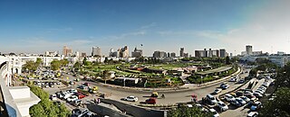
Connaught Place, also known as Rajiv Chowk or CP, is one of the main financial, commercial and business centres in New Delhi, Delhi, India. It houses the headquarters of several noted Indian firms and is a major shopping, nightlife, and tourist destination in New Delhi. As of July 2018, Connaught Place ranked as the ninth most expensive office location in the world, with an annual rent of $1,650 per square meter.

Chanakyapuri is a neighbourhood and diplomatic enclave established in the 1950s in New Delhi, India. It is also a sub-division of the New Delhi district and plays host to the majority of foreign embassies in New Delhi. Chanakyapuri, meaning "city of Chanakya", is named after Chanakya, an ancient Indian diplomat, philosopher, politician, military strategist and advisor to Maurya Emperor Chandragupta Maurya.

Karol Bagh is a neighborhood in Central District of Delhi, India. It is a mixed residential and commercial neighborhood known for shopping streets, such as the Ghaffar Market and Ajmal Khan Road.
Tilak Nagar is a suburban area and commercial hub in the district of West Delhi, Delhi, India.

Mayur Vihar is an upmarket residential area on the periphery of Delhi, located in East Delhi, close to the city's Noida-Delhi border, situated just across the Yamuna River, and is divided into three distinct phases (sectors). As the name suggests, it has been the dwelling (vihar) of peacocks (mayur). Even today, the area has a closed sanctuary dedicated to the conservation of peacocks.

Paharganj is a neighbourhood of Central Delhi, located just west of the New Delhi Railway Station. Known as Shahganj or King's ganj or market place during Mughal era, it is one of the three administrative subdivisions, of the Central Delhi district, of the National Capital Territory of Delhi, with the other two being, Darya Ganj and Karol Bagh.

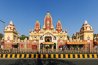
The Laxminarayan Mandir is a Hindu temple located in New Delhi, India. The presiding deity in the temple is Laxminarayan i.e., Vishnu along with his consort Lakshmi. The temple was inaugurated by Mahatma Gandhi. Gandhi ensured that members of all castes would be allowed in the temple. It was built by Jugal Kishore Birla from 1933 and 1939. There are also small shrines on the sides dedicated to Shiva, Ganesha, Hanuman and Buddha.

Chittaranjan Park is an upscale neighborhood in South East Delhi and home to a large Bengali community. It was established on a rocky terrain in the early 1960s under the name EPDP Colony and later renamed after the deshbandhu (patriot) Chittaranjan Das in the 1980s. Nowadays it is considered among the posh localities in South Delhi due to a rise in the market price of its plots. Despite its growing cosmopolitan nature, it remains home to a large Bengali community and is home to Kolkata-style street-food stalls, Bengali cuisine, fish markets, temples, and cultural centers. It hosts many festivities and cultural events. Durga Puja is the most celebrated festival here which boasts magnificent marquee.
Kondli is a census town and a constituency in East Delhi District of the National Capital Territory of Delhi, India. The Kondli area is located very close to U.P Border.

Lutyens' Delhi is an area in New Delhi, India, named after the British architect Edwin Lutyens (1869–1944), who was entrusted with the vast majority of the architectural design and buildings of the city that subsequently emerged as New Delhi during the period of the British Raj. Lutyens' Delhi progressively developed over the period from 1912 to 1931. This also includes the Lutyens Bungalow Zone (LBZ).
Malviya Nagar is a residential locality in South Delhi. Situated between Saket and Hauz Khas, its namesake is the freedom fighter Madan Mohan Malviya.
Defence Colony is a neighbourhood in Delhi. It was built in the 1960s for veterans of the Indian Armed Forces. It serves as the administrative headquarters of the South East Delhi district of Delhi.
New Delhi Kali Bari is a Hindu temple dedicated to Goddess Kali and the center for Bengali culture in New Delhi, India. Established in 1930s, it is situated on Mandir Marg, close to Laxminarayan Temple in Delhi.
Bengali Market is among the oldest and most popular markets in New Delhi, India. The actual name of the market is Bangali Mal Market, but over the years it has come to be known as just Bengali Market, though it has nothing to do with the Indian state of West Bengal. It was built by Bengali Mal Lohia in 1930. It is a relatively small market, comprising several stores situated in a circular manner around a traffic roundabout. Today, it is famous for its North Indian street food, and shops selling sweets such as Nathu's Sweets and Bengali Sweet House.

Sansad Marg is a street located in New Delhi, India. The street gets its name from the Parliament House.

Robert Tor Russell (1888–1972) was a British architect. In his position as Chief Architect to the Public Works Department of the Government of India, he is primarily associated with the development of the city of New Delhi in the early 1930s. He designed some of the city's most notable buildings and was the architect of Connaught Place, the financial centre of the new capital. Russell also served with distinction during the First World War, and later, after retiring from India, became a civil servant for the British Government.
Pusa Road is an arterial road and one of the major roads of New Delhi, India. Several prominent educational institutions and hospitals are located on the road. The neighbourhoods of Karol Bagh and Rajendra Nagar are respectively on the northern and southern sides of the road. It forms part of the Patel Road - Pusa Road - Link Road corridor that connects West Delhi to Connaught Place. This is one of the busiest arterial routes in the city; according to a 2014 estimate, it carries 170,000 vehicles per day.

Sunehri Bagh Masjid is a mosque in Delhi, India, located in Lutyens' Delhi area, constructed during the Mughal era. It is listed as a Grade-III heritage structure and is made of two storeys, and comprises a Bangla dome and four minarets. The mosque was recommended for demolition in August 2023 by the New Delhi Municipal Council (NDMC) for better traffic management, and public opinions were sought in December 2023.


