
Mount Charleston, including Charleston Peak at 11,916 feet (3,632 m), is the highest mountain in both the Spring Mountains and Clark County, in Nevada, United States. It is the eighth-highest mountain in the state. Well separated from higher peaks by large, low basins, Charleston Peak is the most topographically prominent peak in Nevada, and the eighth-most-prominent peak in the contiguous United States. It is one of eight ultra-prominent peaks in Nevada. It is located about 35 miles (56 km) northwest of Las Vegas within the Mount Charleston Wilderness, which is within the Spring Mountains National Recreation Area of the Humboldt–Toiyabe National Forest.

Wheeler Peak is the tallest mountain in the Snake Range and in White Pine County, in Nevada, United States. The summit elevation of 13,065 feet (3,982 m) makes it the second-highest peak in Nevada, just behind Boundary Peak. With a topographic prominence of 7,563 feet (2,305 m), Wheeler Peak is the most topographically prominent peak in White Pine County and the second-most prominent peak in Nevada, just behind Mount Charleston. The mountain is located in Great Basin National Park and was named for George Wheeler, leader of the Wheeler Survey of the late 19th century.

Killington Peak is the second highest summit in the Green Mountains and in the U.S. state of Vermont. It is located east of Rutland in south-central Vermont. Killington Peak is a stop on the Long Trail, which here shares its route with the Appalachian Trail. Traveling southbound on the Trail, it is the last 4,000-foot (1,200 m) peak close to the trail until Virginia.
Ruby Dome is the highest mountain in both the Ruby Mountains and Elko County, in Nevada, United States. It is the twenty-seventh-highest mountain in the state, and also ranks as the thirteenth-most topographically prominent peak in the state. The peak is located about 21 miles (34 km) southeast of the city of Elko within the Ruby Mountains Ranger District of the Humboldt-Toiyabe National Forest. The mountain rises from a base elevation of about 6,000 feet (1,800 m) to a height of 11,387 feet (3,471 m). It is the highest mountain for over 90 miles in all directions.

Castle Peak is a mountain in California's Sierra Nevada near I-80, Donner Pass, and the Nevada border. It is in the Tahoe National Forest not far off the Pacific Crest Trail, and adjacent to Castle Pass. It was originally named Mount Stanford by the Whitney Survey of 1860–1874.

Pilot Peak is the highest mountain in the Pilot Range in extreme eastern Elko County, Nevada, United States. It is the most topographically prominent peak in Elko County and the fourth-most prominent peak in Nevada. The peak is on public land administered by the Bureau of Land Management and thus has no access restrictions.

Split Mountain is a fourteener in the Sierra Nevada of the U.S. state of California, near the southeast end of the Palisades group of peaks. It is the only fourteener in the watershed of the South Fork Kings River, and it rises to 14,064 feet (4,287 m), making it the eighth-highest peak in the state.

Currant Mountain is the highest mountain in the White Pine Range in White Pine County, Nevada, United States. It is the twenty-first-highest mountain in the state, and also ranks as the sixteenth-most topographically prominent peak in the state. Its summit consists of a series of three spires on a thin limestone ridge, with the southern spire being the highest at 11,518 feet (3,511 m). To the west are the Duckwater (Shoshone) tribal lands and the northern arm of large Railroad Valley. To the east is the northern part of White River Valley. The peak is located about 37 miles (60 km) southwest of the community of Ely near the Nye County border, within the Currant Mountain Wilderness of the Humboldt-Toiyabe National Forest.

Arc Dome is the highest mountain of the Toiyabe Range in northwestern Nye County, Nevada, United States. It is the thirteenth-highest mountain in the state. Arc Dome also ranks as the second-most topographically prominent peak in Nye County and the eighth-most prominent peak in the state. The peak is located about 53 miles (85 km) north of the community of Tonopah, within the Arc Dome Wilderness of the Humboldt-Toiyabe National Forest.

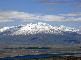
Mount Jefferson is the highest mountain in both the Toquima Range and Nye County in Nevada, United States. It is the sixth highest mountain in the state. As the high point of a range which is well separated from other ranges by low basins, Mount Jefferson has a high topographic prominence of 5,861 feet (1,786 m). This makes it the most prominent peak in Nye County and the third most prominent peak in Nevada. For similar reasons, it is also the highest mountain for over 90 miles in all directions. It is located about 50 miles (80 km) northeast of the county seat of Tonopah within the Alta Toquima Wilderness of the Humboldt-Toiyabe National Forest, near the smaller towns of Carvers and Round Mountain. Three distinct summits are located on a broad area of subalpine tundra: North Summit rises to 11,820 feet (3,603 m), Middle Summit to 11,692 feet (3,564 m), and South Summit to 11,949 feet (3,642 m). During the Pleistocene, alpine glaciers eroded several cirques east of the summit plateau.

North Schell Peak is the highest mountain in the Schell Creek Range of White Pine County, Nevada, United States. It is the ninth-highest mountain in the state, and also ranks as the fifth-most topographically prominent peak in the state. The summit is 19 miles (31 km) northeast of the community of Ely within the High Schells Wilderness of the Humboldt-Toiyabe National Forest.

Mount Tallac is a mountain peak southwest of Lake Tahoe, in El Dorado County, California. The peak lies within the Desolation Wilderness in the Eldorado National Forest. It is quite visible from State Routes 89 and 28, and U.S. Route 50. A "cross of snow" is clearly visible on the mountain's face during the winter, spring, and early summer months.

Freel Peak is a mountain located in the Carson Range, a spur of the Sierra Nevada, near Lake Tahoe in California.
Mount Lola is a mountain in the Sierra Nevada of California. Its summit, located north of Donner Pass and Interstate 80, is the highest point in Nevada County. It is also the highest point in the Sierra Nevada north of Interstate 80. A subsidiary peak 1.2 miles (1.9 km) north of the main summit is highest point in Sierra County at 8,848 feet (2,697 m) NAVD 88.

Mount Rose is the highest mountain in Washoe County, within the Carson Range of Nevada, United States. It ranks thirty-seventh among the most topographically prominent peaks in the state. It is also both the highest and most topographically prominent peak of the greater Sierra Nevada range within the state of Nevada, and the third most topographically prominent peak in the Sierra Nevada overall. It is located in the Mount Rose Wilderness of the Humboldt-Toiyabe National Forest. An extinct volcano, the mountain is in between Lake Tahoe and Reno. State Route 431 traverses Mount Rose Summit southeast of Mount Rose. Due to the high elevation, most of the precipitation that falls on the mountain is snow. The view from Mount Rose facing east is the Truckee Meadows, the second largest population center in Nevada.

Star Peak is both the highest and most topographically prominent mountain in both the Humboldt Range and Pershing County in Nevada, United States. It is the sixth-most topographically prominent peak in Nevada. The peak is on public land administered by the Bureau of Land Management and has no access restrictions.
Piper Peak is the highest mountain in the Silver Peak Range of Esmeralda County in Nevada, United States. It is the most topographically prominent peak in Esmeralda County and ranks twenty-third among the most topographically prominent peaks in Nevada. The peak is on public land administered by the Bureau of Land Management and thus has no access restrictions.

