East Sweden Östra Sverige | |
---|---|
NUTS 1 Region of the EU | |
Eastern Sweden in yellow | |
Country | |
Largest city | Stockholm |
Area | |
• Total | 44,539.9 km2 (17,197.0 sq mi) |
Population (2017-12-31) | |
• Total | 3,995,953 [1] |
ISO 3166 code | SE1 |
East Sweden (Swedish : Östra Sverige) is a NUTS 1 region in Sweden. The region is defined and used by the European Union for statistical purposes, it is not used as a region by Sweden which uses other divisions of the country.
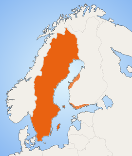
Swedish is a North Germanic language spoken natively by 10 million people, predominantly in Sweden, and in parts of Finland, where it has equal legal standing with Finnish. It is largely mutually intelligible with Norwegian and to some extent with Danish, although the degree of mutual intelligibility is largely dependent on the dialect and accent of the speaker. Both Norwegian and Danish are generally easier for Swedish speakers to read than to listen to because of difference in accent and tone when speaking. Swedish is a descendant of Old Norse, the common language of the Germanic peoples living in Scandinavia during the Viking Era. It has the most speakers of the North Germanic languages.
The Nomenclature of Territorial Units for Statistics is a geocode standard for referencing the subdivisions of countries for statistical purposes. The standard is developed and regulated by the European Union, and thus only covers the member states of the EU in detail. The Nomenclature of Territorial Units for Statistics is instrumental in the European Union's Structural Fund delivery mechanisms and for locating the area where goods and services subject to European public procurement legislation are to be delivered.
The European Union (EU) is a political and economic union of 28 member states that are located primarily in Europe. It has an area of 4,475,757 km2 (1,728,099 sq mi) and an estimated population of about 513 million. The EU has developed an internal single market through a standardised system of laws that apply in all member states in those matters, and only those matters, where members have agreed to act as one. EU policies aim to ensure the free movement of people, goods, services and capital within the internal market, enact legislation in justice and home affairs and maintain common policies on trade, agriculture, fisheries and regional development. For travel within the Schengen Area, passport controls have been abolished. A monetary union was established in 1999 and came into full force in 2002 and is composed of 19 EU member states which use the euro currency.
There are two subdivisions of East Sweden called National Areas of Sweden (NUTS 2). They are in turn comprised out of six different counties (NUTS 3). [2]
The counties of Sweden are the top-level geographic subdivisions of Sweden. Sweden is today divided into 21 counties; however, the numbers of counties has varied over time, due to territorial gains/losses and to divisions and/or mergers of existing counties. This level of administrative unit was first established in the 1634 Instrument of Government on Lord Chancellor Count Axel Oxenstierna's initiative, and superseded the historical provinces of Sweden in order to introduce a more efficient administration of the realm. At that time, they were what the translation of län into English literally means: fiefdoms. The county borders often follow the provincial borders, but the Crown often chose to make slight relocations to suit its purposes.
Uppsala County is a county or län on the eastern coast of Sweden, whose capital is the city of Uppsala. It borders the counties of Dalarna, Stockholm, Södermanland, Västmanland, Gävleborg, and the Baltic Sea.
Örebro County is a county or län in central Sweden. It borders the counties of Västra Götaland, Värmland, Dalarna, Västmanland, Södermanland and Östergötland. It is frequently culturally divided into the hilly northern region of Bergslagen, where mining and metallurgic industry have been important since the Middle Ages, and the southern Mälardalen of lakes and farms.
Västmanland County is a county or län in central Sweden. It borders to the counties of Södermanland, Örebro, Gävleborg, Dalarna and Uppsala. The county also has a stretch of shoreline towards Mälaren.
Stockholm County is a county or län on the Baltic Sea coast of Sweden. It borders Uppsala County and Södermanland County. It also borders Mälaren and the Baltic Sea. The city of Stockholm is the capital of Sweden. Stockholm County is divided by the historic provinces of Uppland (Roslagen) and Södermanland (Södertörn). More than one fifth of the Swedish population lives in the county. Stockholm County is also one of the statistical riksområden according to NUTS:SE, Nomenclature of Territorial Units for Statistics within the EU. With more than two million inhabitants, Stockholm is the most densely populated county of Sweden.
East Middle Sweden is a National Area of Sweden. The National Areas are a part of the Nomenclature of Territorial Units for Statistics (NUTS) of Sweden.
Östergötland County is a county or län in southeastern Sweden. It has land borders with the counties of Kalmar to the southeast, Jönköping to the southwest, Örebro to the northwest, and Södermanland to the northeast. It also has a sea border with Västra Götaland to the west, and borders the Baltic Sea to the east.
Eurostat estimated the regional nominal GDP to be € 206,003 million and the nominal GDP per capita to be €53,600 in a 2015 study. The same study also showed that the region had a 45% higher GDP per capita than the EU average. [3]
The Classification of Territorial Units for Statistics,, is a geocode standard for referencing the administrative divisions of countries for statistical purposes. The standard was developed by the European Union.
In the NUTS codes of Sweden (SE), the three levels are:
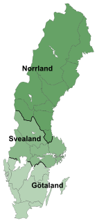
The lands of Sweden are three traditional parts, each consisting of several provinces, in Sweden. The division into lands goes back to the foundation of modern Sweden, when Götaland, the land of the Geats, merged with Svealand, the land of the Swedes, to form the country. While Norrland and Österland were added later. The lands have no administrative function but are still seen by many Swedes as an important part of their identity.
The European Union is the second largest economy in the world in nominal terms and according to purchasing power parity or PPP. The European Union's GDP was estimated to be $18.8 trillion (nominal) in 2018, representing ~22% of global economy.
The development regions of Romania refer to the eight regional divisions created in Romania in 1998 in order to better co-ordinate regional development as Romania progressed towards accession to the European Union. The development regions correspond to NUTS II-level divisions in European Union member states. Despite becoming increasingly significant in regional development projects, Romania's development regions do not actually have an administrative status and do not have a legislative or executive council or government. Rather, they serve a function for allocating European Union PHARE funds for regional development, as well as for collection of regional statistics. They also co-ordinate a range of regional development projects and became members of the Committee of the Regions when Romania joined the EU on January 1, 2007.
Central Transdanubia is a statistical region of Hungary. The capital is Székesfehérvár. It is part of Transdanubia region. Central Transdanubia includes counties of Fejér, Komárom-Esztergom, and Veszprém.
Western Transdanubia is a statistical region of Hungary. It is part of the Transdanubia region. Western Transdanubia includes the counties of Zala, Vas, and Győr-Moson-Sopron.
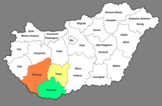
Southern Transdanubia is a statistical region of Hungary. It is part of the Transdanubia region. Southern Transdanubia includes the counties of Somogy, Tolna, and Baranya. Its capital is the city of Pécs.
The Northern Great Plain is a statistical region of Hungary. It is part of the Great Plain and North region. The Northern Great Plain includes the counties of Hajdú-Bihar, Jász-Nagykun-Szolnok, and Szabolcs-Szatmár-Bereg, with a total area of 17,749 km2 (6,853 sq mi) and a population of around 1.5 million.
The Southern Great Plain is a statistical region of Hungary. It is part of Great Plain and North region. The Southern Great Plain includes three counties:
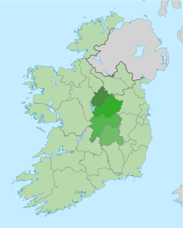
The Midlands Region is a NUTS Level III statistical region of Ireland. It consists of the territory of the counties of Laois, Longford, Offaly and Westmeath. The Midlands region spans 6,524 km2, 9.5% of the total area of the state and according to the 2016 census has a population of 292,301.
Severozapaden is a region of Bulgaria. The capital is the city of Pleven. The region has the lowest-ranked economy in Bulgaria and the European Union, with a GDP per capita of €7,100 or 27% of EU27 average (2008). It includes five administrative divisions or oblasts: Vidin Province, Vratsa Province, Montana Province, Lovech Province and Pleven Province.
The West Region is a NUTS Level III statistical region of the Republic of Ireland. It consists of the territory of the city of Galway and the counties of Galway, Mayo and Roscommon. The West region spans 13,801 km² and has a population of 380,057.
The București - Ilfov development region is a development region in Romania, encompassing the national capital, Bucharest, as well as the surrounding Ilfov County. As other development regions, it does not have any administrative powers, its main function being to co-ordinate regional development projects and manage funds from the European Union. It is also used as an entity in regional statistical analysis at the European Union NUTS-II level.
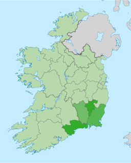
The South-East Region is a NUTS Level III statistical region of Ireland. It consists of the territory of counties Carlow, Kilkenny, Waterford and Wexford. The South-East region spans 7,198 km2, 10.2% of the total area of the state and according to the 2016 census had a population of 422,062.