Related Research Articles

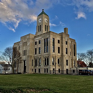
Huron County is a county located in the U.S. state of Ohio. As of the 2020 census, the population was 58,565. Its county seat is Norwalk. The county was created in 1809 and later organized in 1815.
Erie County is a county located in the northern portion of the U.S. state of Ohio. As of the 2020 census, the population was 75,622. Its county seat and largest city is Sandusky. The county is named for the Erie tribe, whose name was their word for "wildcat". It was formed in 1838 from the northern third of Huron County and a portion of Sandusky County.
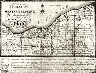
The Firelands, or Sufferers' Lands, tract was located at the western end of the Connecticut Western Reserve in what is now the U.S. state of Ohio. It was legislatively established in 1792, as the "Sufferers' Lands", and later became named "Fire Lands" because the resale of the land was intended as financial restitution for residents of the Connecticut towns of Danbury, Fairfield, Greenwich, Groton, New Haven, New London, Norwalk, and Ridgefield. Their homes had been burned in 1779 and 1781 by British forces during the American Revolutionary War. However, most of the settlement of the area did not occur until after the War of 1812. "Fire Lands" was later spelled as one word: "Firelands."

The Huron River is a 14.9-mile-long (24.0 km) waterway in the north central Ohio in the United States. The watershed drains large portions of Erie County and Huron County, the northeast corners of Seneca County and Crawford County, and northern portions of Richland County.
White Rock is an unincorporated community in Huron County in the U.S. state of Michigan. The community is located within Sherman Township. As an unincorporated community, White Rock has no legal autonomy, defined boundaries, or population statistics of its own. It is located at 43°42′35″N82°36′31″W, about three miles north of Forestville and about nine miles south of Harbor Beach on M-25 at the junction with White Rock Road.

Danbury Township is one of the twelve townships of Ottawa County, Ohio, United States. The 2020 census found 4,924 people in the township.

Townsend Township is one of the nineteen townships of Huron County, Ohio, United States. As of the 2020 census the population of the township was 1,571.

Wakeman Township is one of the nineteen townships of Huron County, Ohio, United States. As of the 2020 census the population of the township was 2,761.

Sullivan is an unincorporated community and census designated place in central Sullivan Township, Ashland County, Ohio, United States. It has a post office with the ZIP code 44880. It lies at the intersection of U.S. Route 224 with State Route 58.

Collins is a census-designated place (CDP) in central Townsend Township, Huron County, Ohio, United States. As of the 2020 census the population of the CDP was 628. The CDP includes the unincorporated communities of Collins and East Townsend. Collins has a post office, with the ZIP code of 44826.
Avery is an unincorporated community in western Milan Township, Erie County, Ohio, United States. It is part of the Sandusky Metropolitan Statistical Area. Avery is located along US Route 250 near that road's interchange with Interstate 80 and Interstate 90, the Ohio Turnpike. The area is characterized by hotels and some industry. It once had a post office, but is now included in the Milan, Ohio postal zone (44846).

Clarksfield is an unincorporated community in the northwestern portion of Clarksfield Township, Huron County, Ohio, United States. It lies along State Route 18 midway between Norwalk and Wellington, and along State Route 60 between New London and Wakeman. The Vermilion River flows northward through Clarksfield.

Bloomingville is an unincorporated community in northern Oxford Township, Erie County, Ohio, United States. It is part of the Sandusky Metropolitan Statistical Area. Bloomingville is located at the intersection of Mason Road and Patten Tract Road. The Oxford Grange Hall located where Taylor Road forks off from Mason was the center of community life for many years. The compact community consisted primarily of farmhouses clustered near the main intersection. Many of the farmhouses had working farms adjoining them or nearby. To the northeast lay an unused tract of 9,000 acres (36 km2) that had been the site of a World War II munitions factory. In 1957, NASA acquired part of this tract for its Plum Brook Station and by 1963 had acquired the rest of the tract to build additional facilities there.

Hunts Corners is an unincorporated community in southeastern Lyme Township, Huron County, Ohio, United States. It lies at the intersection of State Route 547 and Sand Hill Road, southeast of Bellevue and southwest of the city of Norwalk, the county seat of Huron County. Its elevation is 768 feet (234 m), and it is located at 41°13′39″N82°45′27″W.
Fitchville is an unincorporated community in Fitchville Township, Huron County, Ohio, United States. It is part of the Norwalk Micropolitan Statistical Area. Fitchville is located at the intersection of U.S. Route 250, State Route 13, and State Route 162. The community has no post office of its own and is assigned the New London zip code of 44851. The Mansion Hotel was a prominent Fitchville landmark for one hundred and thirty years from 1839 to 1968. It was reputed to have hosted Abraham Lincoln, and served as an overnight resting place for many escaping slaves travelling on the "underground railroad".

Olena is an unincorporated community in Huron County, Ohio, United States.
Centerton is an unincorporated community in Huron County, Ohio, United States.
Havana is an unincorporated community in Huron County, Ohio, United States.
York is an unincorporated community in Sandusky County, in the U.S. state of Ohio.
Boughtonville is an unincorporated community in Huron County, in the U.S. state of Ohio.
References
- ↑ U.S. Geological Survey Geographic Names Information System: East Townsend, Ohio
- ↑ Baughman, Abraham J. (1909). History of Huron County, Ohio: Its Progress and Development, with Biographical Sketches of Prominent Citizens of the County, Volume 1. S. J. Clarke Publishing Company. p. 271.
Municipalities and communities of Huron County, Ohio, United States | ||
|---|---|---|
| Cities |  | |
| Villages | ||
| Townships | ||
| CDPs | ||
| Unincorporated communities | ||
| Footnotes | ‡This populated place also has portions in an adjacent county or counties | |
41°14′55″N82°29′31″W / 41.24861°N 82.49194°W
| | This Huron County, Ohio state location article is a stub. You can help Wikipedia by expanding it. |