Greenwich, Ohio

Last updated

Greenwich, Ohio
Greenwich downtown.jpg
Main Street downtown
OHMap-doton-Greenwich.png
Location of Greenwich, Ohio
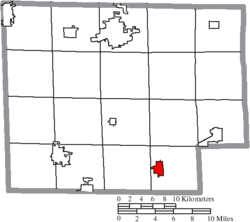
Map of Huron County Ohio Highlighting Greenwich Village.png
Location of Greenwich in Huron County
Coordinates: 41°01′54″N82°31′11″W / 41.03167°N 82.51972°W / 41.03167; -82.51972
Country United States
State Ohio
County Huron
Government
  MayorJames M. Twaddle[ citation needed ]
Area
[1]
  Total1.56 sq mi (4.03 km2)
  Land1.52 sq mi (3.93 km2)
  Water0.04 sq mi (0.10 km2)
Elevation
[2]
1,037 ft (316 m)
Population
 (2020)
  Total1,409
  Estimate 
(2023) [3]
1,389
  Density928.81/sq mi (358.52/km2)
Time zone UTC-5 (Eastern (EST))
  Summer (DST) UTC-4 (EDT)
ZIP code
44837
Area code 419
FIPS code 39-32368 [4]
GNIS feature ID2398206 [2]

Greenwich is a village in Huron County, Ohio, United States. The population was 1,409 at the 2020 census. It is served by a branch of the Willard Memorial Library.

Contents

History

A post office called Greenwich was established in 1828 and the municipality was incorporated as a village in 1879. [5] [6] The village name comes from Greenwich Township, which is named after the town of Greenwich, Connecticut. [7]

Geography

According to the United States Census Bureau, the village has a total area of 1.37 square miles (3.55 km2), of which 1.35 square miles (3.50 km2) is land and 0.02 square miles (0.05 km2) is water. [8]

Demographics

Historical population
CensusPop.Note
1880 647
1890 88136.2%
1900 849−3.6%
1910 8763.2%
1920 827−5.6%
1930 95615.6%
1940 9964.2%
1950 1,20420.9%
1960 1,37113.9%
1970 1,4737.4%
1980 1,458−1.0%
1990 1,442−1.1%
2000 1,5255.8%
2010 1,476−3.2%
2020 1,409−4.5%
2023 (est.)1,389 [3] −1.4%
U.S. Decennial Census [9]

2010 census

As of the census [10] of 2010, there were 1,476 people, 570 households, and 404 families living in the village. The population density was 1,093.3 inhabitants per square mile (422.1/km2). There were 632 housing units at an average density of 468.1 per square mile (180.7/km2). The racial makeup of the village was 99.1% White, 0.2% African American, 0.4% Asian, 0.1% from other races, and 0.3% from two or more races. Hispanic or Latino of any race were 1.1% of the population.

There were 570 households, of which 38.8% had children under the age of 18 living with them, 52.5% were married couples living together, 13.0% had a female householder with no husband present, 5.4% had a male householder with no wife present, and 29.1% were non-families. 25.3% of all households were made up of individuals, and 12.1% had someone living alone who was 65 years of age or older. The average household size was 2.57 and the average family size was 3.07.

The median age in the village was 36.1 years. 27.6% of residents were under the age of 18; 6.9% were between the ages of 18 and 24; 27.5% were from 25 to 44; 25% were from 45 to 64; and 13% were 65 years of age or older. The gender makeup of the village was 50.3% male and 49.7% female.

2000 census

As of the census [4] of 2000, there were 1,525 people, 579 households, and 412 families living in the village. The population density was 1,124.0 inhabitants per square mile (434.0/km2). There were 610 housing units at an average density of 449.6 per square mile (173.6/km2). The racial makeup of the village was 98.23% White, 0.07% Native American, 0.07% Asian, 0.39% from other races, and 1.25% from two or more races. Hispanic or Latino of any race were 0.59% of the population.

There were 579 households, out of which 36.4% had children under the age of 18 living with them, 56.0% were married couples living together, 12.3% had a female householder with no husband present, and 28.8% were non-families. 23.7% of all households were made up of individuals, and 10.4% had someone living alone who was 65 years of age or older. The average household size was 2.63 and the average family size was 3.10.

In the village, the population was spread out, with 28.8% under the age of 18, 9.0% from 18 to 24, 29.5% from 25 to 44, 20.0% from 45 to 64, and 12.7% who were 65 years of age or older. The median age was 34 years. For every 100 females there were 90.4 males. For every 100 females age 18 and over, there were 86.3 males.

The median income for a household in the village was $31,625, and the median income for a family was $39,375. Males had a median income of $30,833 versus $21,523 for females. The per capita income for the village was $14,667. About 8.9% of families and 10.1% of the population were below the poverty line, including 10.6% of those under age 18 and 11.5% of those age 65 or over.

Education

South Central Local Schools operates South Central High School. [11]

Greenwich has a public library, a branch of the Huron County Community Library. [12]

Notable person

Related Research Articles

<span class="mw-page-title-main">Huron County, Ohio</span> County in Ohio, United States

Huron County is a county located in the U.S. state of Ohio. As of the 2020 census, the population was 58,565. Its county seat is Norwalk. The county was created in 1809 and later organized in 1815. Huron County is included in the Norwalk, OH Micropolitan Statistical Area, which is also included in the Cleveland-Akron-Canton, OH Combined Statistical Area.

<span class="mw-page-title-main">Kinde, Michigan</span> Village in Michigan, United States

Kinde is a village in Huron County in the U.S. state of Michigan. The population was 448 at the 2010 census.

<span class="mw-page-title-main">Pigeon, Michigan</span> Village in Michigan, United States

Pigeon is a village in Huron County in the U.S. state of Michigan. The population was 1,208 at the 2010 census. The village is within Winsor Township.

<span class="mw-page-title-main">South Rockwood, Michigan</span> Village in Michigan, United States

South Rockwood is a village in Monroe County in the U.S. state of Michigan. The population was 1,587 at the 2020 census. The village is located within Berlin Charter Township.

<span class="mw-page-title-main">Aberdeen, Ohio</span> Village in Ohio, United States

Aberdeen is a village in Huntington Township, Brown County, Ohio, United States, along the Ohio River 50 miles (80 km) southeast of Cincinnati. The population was 1,515 at the 2020 census.

<span class="mw-page-title-main">Castalia, Ohio</span> Village in Ohio, United States

Castalia is a village in Erie County, Ohio, United States. The population was 774 at the 2020 census. It is part of the Sandusky, Ohio Metropolitan Statistical Area.

<span class="mw-page-title-main">Crown City, Ohio</span> Village in Ohio, United States

Crown City is a village in Gallia County, Ohio, United States, along the Ohio River. The population was 424 at the 2020 census.

<span class="mw-page-title-main">Addyston, Ohio</span> Village in Ohio, United States

Addyston is a village in Miami Township, Hamilton County, Ohio, United States. Located along the Ohio River, it is a western suburb of the neighboring city of Cincinnati. The population was 927 at the 2020 census.

<span class="mw-page-title-main">Cleves, Ohio</span> Village in Ohio, United States

Cleves is a village in Miami Township, Hamilton County, Ohio, United States. Located along the Ohio River, it is a western suburb of Cincinnati. The population was 3,414 at the 2020 census.

<span class="mw-page-title-main">Woodlawn, Ohio</span> Village in Ohio, United States

Woodlawn is a village in Hamilton County, Ohio, United States. The population was 3,916 at the 2020 census.

<span class="mw-page-title-main">Monroeville, Ohio</span> Village in Ohio, United States

Monroeville is a village in Huron County, Ohio, United States. The population was 1,300 at the 2020 census.

<span class="mw-page-title-main">North Fairfield, Ohio</span> Village in Ohio, United States

North Fairfield is a village in Huron County, Ohio, United States. The population was 465 at the 2020 census.

<span class="mw-page-title-main">Wakeman, Ohio</span> Village in Ohio, United States

Wakeman is a village in Huron County, Ohio, United States, along the Vermilion River. Its namesake was Jesup Wakeman, an early settler of Fairfield County, Connecticut, who was involved in western land speculation between 1800 and 1840. The population was 990 at the 2020 census.

<span class="mw-page-title-main">Hebron, Ohio</span> Village in Ohio, USA

Hebron is a village in Licking County, Ohio, United States. The population was 2,326 at the 2020 census.

<span class="mw-page-title-main">Clarksburg, Ohio</span> Village in Ohio, United States

Clarksburg is a village in Ross County, Ohio, United States. The population was 409 at the 2020 census.

<span class="mw-page-title-main">Limaville, Ohio</span> Census-designated place in Ohio, United States

Limaville is a census-designated place (CDP) and former village in Stark County, Ohio, United States. The population was 151 at the 2020 census. It is part of the Canton–Massillon Metropolitan Statistical Area.

<span class="mw-page-title-main">Greenwich Township, Pennsylvania</span> Township in Pennsylvania, United States

Greenwich Township is a township in Berks County, Pennsylvania, United States. The population was 3,438 at the 2020 census.

<span class="mw-page-title-main">Wilson, Ohio</span> Village in Ohio, United States

Wilson is a village in Belmont and Monroe counties in the U.S. state of Ohio. The population was 129 at the 2020 census. It is part of the Wheeling metropolitan area.

<span class="mw-page-title-main">Milan, Ohio</span> Village in Ohio, United States

Milan is a village in Erie and Huron counties in the U.S. state of Ohio. The population was 1,371 at the 2020 census. It is best known as the birthplace and childhood home of Thomas Edison.

<span class="mw-page-title-main">Gratiot, Ohio</span> Village in Ohio, United States

Gratiot is a village in Licking and Muskingum counties in the U.S. state of Ohio. The population was 215 at the 2020 census.

References

  1. "ArcGIS REST Services Directory". United States Census Bureau. Retrieved September 20, 2022.
  2. 1 2 U.S. Geological Survey Geographic Names Information System: Greenwich, Ohio
  3. 1 2 "Annual Estimates of the Resident Population for Incorporated Places in Ohio: April 1, 2020 to July 1, 2023". United States Census Bureau. Retrieved July 6, 2024.
  4. 1 2 "U.S. Census website". United States Census Bureau . Retrieved January 31, 2008.
  5. "Post offices". Jim Forte Postal History. Retrieved June 11, 2016.
  6. Baughman, Abraham J. (1909). History of Huron County, Ohio: Its Progress and Development, with Biographical Sketches of Prominent Citizens of the County, Volume 1. S. J. Clarke Publishing Company. p. 232.
  7. Overman, William Daniel (1958). Ohio Town Names. Akron, OH: Atlantic Press. p. 54.
  8. "US Gazetteer files 2010". United States Census Bureau. Archived from the original on January 25, 2012. Retrieved January 6, 2013.
  9. "Census of Population and Housing". Census.gov. Retrieved June 4, 2015.
  10. "U.S. Census website". United States Census Bureau . Retrieved January 6, 2013.
  11. "Homepage". South Central Local Schools. Retrieved February 26, 2018.
  12. "Homepage". Huron County Community Library. Retrieved February 26, 2018.