
Arsi is one of the zones of the Oromia in Ethiopia. named after a clan of the Oromo, who inhabit in the area.
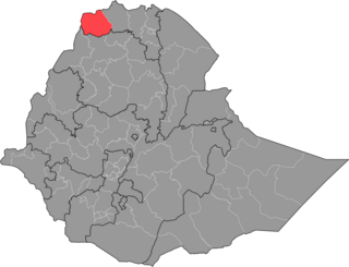
The Western Zone is a zone in the Tigray Region of Ethiopia. It is subdivided into three woredas (districts); from north to south they are Kafta Humera, Welkait and Tsegede. The largest town is Humera. The Western Zone is bordered on the east by the North Western Zone, the south by the Amhara Region, the west by Sudan and on the north by Eritrea.

The Central Zone is a zone in the Tigray Region of Ethiopia. Towns and cities in the Central Zone include Axum and Adwa, as well as the historically significant village of Yeha and the town of Tembien Abiyi Adi. The Central Zone is bordered on the east by the Eastern Zone, on the south by South Eastern Zone, on the west by North Western Zone and on the north by Eritrea.

Debubawi, formerly also known as Zoba Enderta, is a zone in Tigray Region of Ethiopia. Debubawi is bordered on the south and west by the Amhara Region, on the north by Debub Misraqawi Zone, and on the east by the Afar Region. Towns and cities in Debubawi include Maychew, Korem, Alamata. Debub Misraqawi Zone was separated from Debubawi Zone.
North Gondar is a zone in the Amhara Region of Ethiopia. This zone is named for the city of Gondar, the capital of Ethiopia until the mid-19th century.

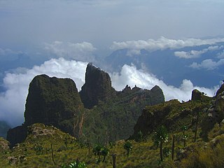
North Wollo also called Semien Wollo, is a zone in Amhara Region of Ethiopia. It is bordered on the south by South Wollo, on the west by South Gondar, on the north by Wag Hemra, on the northeast by Tigray Region, and on the east by Afar Region; part of its southern border is defined by the Mille River. Its highest point is Mount Abuna Yosef. Its towns include Lasta Lalibela and Weldiya. North Wollo acquired its name from the former province of Wollo.

North Shewa is a zone in the Amhara Region of Ethiopia. North Shewa takes its name from the kingdom and former province of Shewa. The Zone is bordered on the south and the west by the Oromia Region, on the north by South Wollo, on the northeast by the Oromia Zone, and on the east by the Afar Region. The highest point in the Zone is Mount Abuye Meda, which is found in the Gish woreda; other prominent peaks include Mount Megezez. Towns in North Shewa include Ankober, Debre Birhan, and Shewa Robit.

Sitti Zone, formerly known as Shinile, is a zone in Somali Region of Ethiopia.

Fafan is a zone in Somali Region of Ethiopia. It was previously known as the Jijiga zone, so named after its largest city, Jijiga. Other towns and cities in this zone include Harshin, Awbare, Derwernache, Kebri Beyah, Tuli Gulled and Hart Sheik. Fafan is bordered on the south by Jarar, on the southwest by Nogob, on the west by the Oromia Region, on the north by Sitti, and on the east by Somaliland.

Korahe is one of eleven Zones of the Somali Region of Ethiopia. Korahe is bordered on the southwest by the Gode, on the northwest by Fiq, on the north by Degehabur, on the east by Werder, and on the southeast by Somalia's federal state of Galmudug. The largest city in Korahe is Kebri Dahar.

Kilbet Rasu is one of five Zones of the Afar Region of Ethiopia. This zone is bordered on the south by Administrative Zone 1, on the southwest by Administrative Zone 4, on the west by the Tigray Region, and on the northeast by Eritrea. The administrative center of Zone 2 is Abala. Also located in this zone is the former mining settlement of Dallol, which set the record for the hottest inhabited place on Earth, with an average temperature of 34° C.

Administrative Zone 4 is a zone in Afar Region of Ethiopia. This zone is bordered on the south and east by Administrative Zone 1, on the southwest by the Amhara Region, on the northwest by the Tigray Region, and on the north by Administrative Zone 2. The administrative center of the Zone is Kaluwan ; the largest town is Dibina.

Irob is a district or woreda in the Tigray Region of Ethiopia. This woreda is named after the Irob people, who are the predominant ethnic group living there. Located in the Misraqawi Zone at the eastern escarpment of the Ethiopian highlands, Irob is bordered on the south by Saesi Tsaedaemba, on the west by Gulomahda, on the north and east by the Endelli River which separates it from Eritrea, and on the southeast by the Afar Region. The administrative center of this woreda is Dawhan; other towns include Alitena, the former administrative center.

La'ilay Adiyabo is one of the Districts of Ethiopia, or woredas, in the Tigray Region of Ethiopia. Part of the Semien Mi'irabawi Zone, La'ilay Adiyabo is bordered on the south by Tahtay Koraro, on the southwest by Asigede Tsimbela, on the northwest by Tahtay Adiyabo, on the northeast by the Mareb River which separates it from Eritrea, on the east by the Mehakelegnaw (Central) Zone, and on the southeast by Medebay Zana. The administrative center of this woreda is Addi Daero; other towns in La'ilay Adiyabo include Addi Nebreid.
Enticho is one of woredas in the Tigray Region of Ethiopia. Part of the Maekelay Zone, Enticho is bordered on the south by Werie Lehe, on the southwest by Adwa, on the west by Mereb Lehe, on the north by Eritrea, and on the east by the Misraqawi (Eastern) Zone. The administrative center of this woreda is Enticho; other towns in Enticho include Edaga Arbi, and Gerhusernay. Ancient monastery of Debre Damo is also located in Enticho.

Gulomakeda is one of the Districts of Ethiopia, or woredas, in the Tigray Region of Ethiopia. Its name partly comes from the legendary Queen Makeda, also known as the Queen of Sheba. Part of the Misraqawi Zone, Gulomakeda is bordered on the south by Ganta Afeshum, on the west by the [zoba Maekel (Central)], on the north by Eritrea, on the east by Irob, and on the southeast by Saesi Tsaedaemba. Towns in Gulomakeda include Fatsi, Sebeya and Zalambessa. Gulomakeda has many historical places like Debredamo. Wereda Gulomakeda has 2 preparatory schools Yemane senior secondary school and Zalambessa senior secondary school. Notable local landmarks in this woreda include ruins that have been dated to the Axumite Kingdom, as well as to the period prior to its rise. Archeological surveys conducted by Dr. Catherine D'Andrea of Simon Fraser University show that far from being a rural hinterland, Gulomakeda had large towns with elite groups who had access to exotic trade goods during that time. She also identified cultural links to ancient Eritrean settlements, which included Matara and the ancient Ona culture.

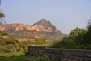
Saesi Tsaedaemba is one of the Districts of Ethiopia, or woredas, in the Tigray Region of Ethiopia. Located in the Misraqawi Zone at the eastern edge of the Ethiopian highlands, Saesi Tsaedaemba is bordered on the south by Kilte Awulaelo, on the southwest by Hawzen, on the west by Ganta Afeshum, on the northwest by Gulomahda, on the north by Irob, on the east by the Afar Region, and on the southeast by Atsbi Wenberta. Towns in Saesi Tsaedaemba include Edaga Hamus and Freweyni also known as Sinkata) where the woreda office is located.

Kilte Awulaelo is one of the Districts of Ethiopia, or woredas, in the Tigray Region of Ethiopia. Part of the Misraqawi Zone, Kilte Awulaelo is bordered on the south by the Debub Misraqawi (Southeastern) Zone, on the west by the Mehakelegnaw (Central) Zone, on the northeast by Hawzen, on the north by Saesi Tsaedaemba, and on the east by Atsbi Wenberta. Towns in the Kilte Awulaelo woreda include Agula, Tsigereda and Maimekden. Town of Wukro is surrounded by Kilte Awulaelo.
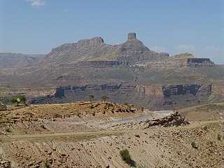
Enderta is one of the Districts of Ethiopia or woredas in the Tigray Region of Ethiopia. It was named for the former Enderta province, which was later merged into Tigray Province. Located in the Debub Misraqawi (Southeastern) Zone at the eastern edge of the Ethiopian highlands Enderta is bordered on the south by Hintalo Wajirat, on the west by Samre, on the northwest by the Mehakelegnaw (Central) Zone, on the north by the Misraqawi (Eastern) Zone, and on the east by the Afar Region; the city and special zone of Mek'ele is an enclave within Enderta. Towns in Enderta include Aynalem and Qwiha; the historic village of Chalacot is also located in this woreda.
Debub Misraqawi is a zone in Tigray Region of Ethiopia. Debub Misraqawi is bordered on the south by Debubawi (Southern) Zone, on the southeast by the Amhara Region, on the northeast by Mehakelegnaw (Central) Zone, on the north by Misraqawi (Eastern) Zone, and on the east by the Afar Region. Mekelle Special Zone is surrounded by Debub Misraqawi. Debub Misraqawi was separated from Debubawi Zone.

