Echo Bay, British Columbia

Last updated

Echo Bay
Echo Bay Resort.jpg
Echo Bay Resort
Canada British Columbia location map 2.svg
Red pog.svg
Echo Bay
Location of Echo Bay in British Columbia
Coordinates: 50°45′00″N126°29′41″W / 50.75000°N 126.49472°W / 50.75000; -126.49472
CountryFlag of Canada (Pantone).svg  Canada
Province Flag of British Columbia.svg  British Columbia
Regional District Mount Waddington
Area code(s) 250, 778

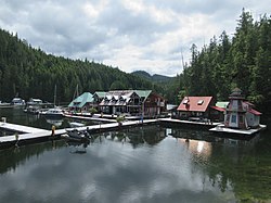
Echo Bay is an unincorporated settlement located on the west side of Gilford Island in the Broughton Archipelago on the Central Coast of British Columbia, Canada. It is the location of the Simoom Sound post office, which used to be on the nearby Wishart Peninsula facing the sound of the same name.

Contents

See also

Related Research Articles

<span class="mw-page-title-main">Strait of Georgia</span> Waterway between Vancouver Island and mainland North America

The Strait of Georgia or the Georgia Strait is an arm of the Salish Sea between Vancouver Island and the extreme southwestern mainland coast of British Columbia, Canada, and the extreme northwestern mainland coast of Washington, United States. It is approximately 240 kilometres (150 mi) long and varies in width from 20 to 58 kilometres. Along with the Strait of Juan de Fuca and Puget Sound, it is a constituent part of the Salish Sea.

Echo Bay may refer to

Baynes Sound is the channel between Denman Island and Vancouver Island, British Columbia, Canada. The sound is a narrow western offshoot of the Strait of Georgia that separates Vancouver Island from the mainland of British Columbia. The area is actively harvested by the local oyster industry, as is apparent by an abundance of oyster farms. It produces 39% of the oysters and 55% of the manila clams farmed in British Columbia. The sound is 40 km (25 mi) long and is 3.5 km (2.2 mi) wide at its widest point, although the average width is less than 2 km (1.2 mi). The southern boundary lies around Chrome Island, a small island off Boyle Point, the southern tip of Denman. The northern boundary is less defined, but lies between Tree Island at the northern end of Denman and the Comox harbour. The sound is dotted with the small communities of Royston, Union Bay, Buckley Bay, Mud Bay, Fanny Bay, and Deep Bay on Vancouver Island. The crossing is served by the British Columbia Ferry Services Inc. ship MV Baynes Sound Connector, between Buckley Bay and Denman Island. Baynes Sound is named after British Rear Admiral Robert L. Baynes, who commanded the Pacific Squadron from 1857 to 1860. Baynes Sound is the home of Vancouver Island University Center for Shellfish Research's Deep Bay Marine Field Station.

<span class="mw-page-title-main">Howe Sound</span> Sound in Canada

Howe Sound is a roughly triangular sound, that joins a network of fjords situated immediately northwest of Vancouver, British Columbia, Canada. It was designated as a UNESCO Biosphere Reserve in 2021.

<span class="mw-page-title-main">Harrison Lake</span> Lake in British Columbia, Canada

Harrison Lake is the largest lake in the southern Coast Mountains of Canada, being about 250 square kilometres (95 mi²) in area. It is about 60 km (37 mi) in length and at its widest almost 9 km (5.6 mi) across. Its southern end, at the resort community of Harrison Hot Springs, is c. 95 km east of downtown Vancouver. East of the lake are the Lillooet Ranges while to the west are the Douglas Ranges. The lake is the last of a series of large north-south glacial valleys tributary to the Fraser along its north bank east of Vancouver, British Columbia. The others to the west are the Chehalis, Stave, Alouette, Pitt, and Coquitlam Rivers.

<span class="mw-page-title-main">Vancouver Island Air</span> Canadian airline

Vancouver Island Air is a Vancouver Island seaplane company serving the British Columbia Coast, based in Campbell River.

<span class="mw-page-title-main">Echo Bay Marine Provincial Park</span> Provincial Park in British Columbia, Canada

Echo Bay Marine Provincial Park is a provincial park in British Columbia, Canada, established in 1971 and containing 1.5 hectares. It is located at the bay of the same name, offshore from the community of the same name, which is the location of the Simoom Sound post office and is on the west side of Gilford Island.

<span class="mw-page-title-main">Cortes Island</span> Island of the Discovery Islands in British Columbia, Canada

Cortes Island is an island in the Discovery Islands archipelago on the coast of British Columbia, Canada. The island is 25 km (16 mi) long, 13 km (8 mi) wide, and 130 km2 (50 sq mi) in area. It has a population of 1,035 permanent residents. Cortes Island lies within Electoral Area B of the Strathcona Regional District, which provides water and sewerage systems, fire protection, land use planning, parks, recreation, and emergency response.

Gambier Island is an island located in Howe Sound near Vancouver, British Columbia. It is about 17,049 acres in size and is located about 10 kilometres north of the Horseshoe Bay community and ferry terminal in westernmost West Vancouver.

<span class="mw-page-title-main">Puget Sound Navigation Company</span> Steamboat and ferry company, founded 1898

The Puget Sound Navigation Company (PSNC) was founded by Charles E. Peabody in 1898. Today the company operates an international passenger and vehicle ferry service between Port Angeles, Washington, United States and Victoria, British Columbia, Canada on the MV Coho, through its operating company, Black Ball Ferry Line.

Kyuquot Sound is a complex of coastal inlets, bays and islands on northwestern Vancouver Island in the Canadian province of British Columbia.

<span class="mw-page-title-main">Broughton Archipelago</span>

Broughton Archipelago is a group of islands located at the eastern end of Queen Charlotte Strait in Mount Waddington Regional District, British Columbia. The archipelago is the traditional territory of the Musgamagw Dzawada'enuxw, Namgis, Ma'amtagila and Tlowitsis nations of the Kwakwaka'wakw peoples.

Wright Sound is a waterway on the North Coast of British Columbia, Canada. Wright Sound is 135 kilometers (84 mi) south of Prince Rupert and lies at the southern opening of Grenville Channel and between Gil, Gribbell and Pitt Islands. The small town of Hartley Bay sits on its northern shore and is home to the Gitga'ata, a Tsimshian group. On the north side of Wright Sound develops the Douglas Channel.

<span class="mw-page-title-main">Quatsino Sound</span> Body of water on the coast of Vancouver Island in British Columbia, Canada

Quatsino Sound is a complex of coastal inlets, bays and islands on northwestern Vancouver Island in the Canadian province of British Columbia. It is the northernmost of the five sounds that pierce the west coast of Vancouver Island, the others being Kyuquot Sound, Nootka Sound, Clayoquot Sound, and Barkley Sound.

<span class="mw-page-title-main">Masset Inlet</span>

Masset Inlet is a large saltwater bay located in the heart of the lowland of northern Graham Island, the northernmost and largest island of the Haida Gwaii islands on the North Coast of British Columbia, Canada. It is fed by several rivers, the largest of which is the Yakoun River, and is connected to the open sea of the Dixon Entrance by the narrow Masset Sound and Masset Harbour, which opens onto McIntyre Bay. The communities of Port Clements and Sewall are located on the shores of Masset Inlet. The community of Juskatla is located on Juus Ḵáahlii, the largest of Masset Inlet's arms. There are several islands in the inlet, the largest of which is Kumdis Island, at the inlet's egress to Masset Sound and just north of Port Clements. Masset Inlet helps form the isthmus of the Naikoon Peninsula.

Simoom Sound is a sound on the Central Coast of British Columbia, Canada, located on the east and north sides of the Wishart Peninsula between Tribune Channel and Kingcome Inlet. The former steamer landing, now classified as a "locality", and the post office of Simoom Sound, British Columbia, located in Echo Bay on Gilford Island, is named after the sound. Kawages Indian Reserve No. 4 is located on the north side of Simoom Sound and is a reserve of the Dzawada'enuxw First Nation of the Kwakwaka'wakw peoples.

Simoom Sound is a post office located at Echo Bay, British Columbia, Canada, on Gilford Island in the Central Coast region adjacent to the body of water of the same name, which was named for HMS Simoom. The name formerly applied to a location on the nearby Wishart Peninsula as a steamer landing but was moved to Echo Bay when the former location became depopulated.

<i>Cowichan</i> (steamship)

Cowichan was a steamship which was operated in British Columbia under the ownership of the Union Steamship Company. Cowichan sank in 1925 following a collision with another ship.

<span class="mw-page-title-main">Checleset Bay</span> Bay in British Columbia, Canada

Checleset Bay is a bay on the northwest coast of Vancouver Island, British Columbia, Canada. It is located southeast of Brooks Peninsula and northwest of Kyuquot Sound. Much of the land around the bay is part of Brooks Peninsula Provincial Park. Checleset Bay has three large inlets, Nasparti Inlet, Ououkinsh Inlet, and Malksope Inlet.

References

Commons-logo.svg Media related to Echo Bay (British Columbia) at Wikimedia Commons