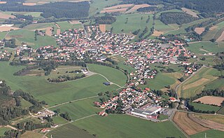
| Egg a.d.Günz | ||
|---|---|---|
Saint Bartholomew Church | ||
| ||
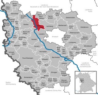
 Egg a.d.Günz Location of Egg a.d.Günz within Unterallgäu district 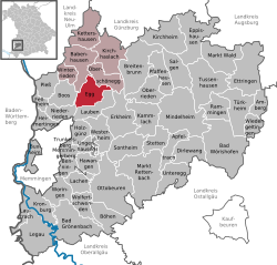 | ||
| Coordinates: 48°5′N10°17′E / 48.083°N 10.283°E Coordinates: 48°5′N10°17′E / 48.083°N 10.283°E | ||
| Country | Germany | |
| State | Bavaria | |
| Admin. region | Schwaben | |
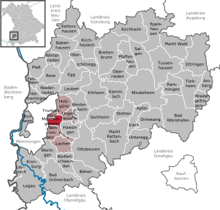
| District | Unterallgäu | |
| Municipal assoc. | Babenhausen | |
| Government | ||
| • Mayor | Franz Morath (FW) | |
| Area | ||
| • Total | 20.65 km2 (7.97 sq mi) | |
| Elevation | 580 m (1,900 ft) | |
| Population (2016-12-31) [1] | ||
| • Total | 1,141 | |
| • Density | 55/km2 (140/sq mi) | |
| Time zone | CET/CEST (UTC+1/+2) | |
| Postal codes | 87743 | |
| Dialling codes | 08333 | |
| Vehicle registration | MN | |
| Website | www.gemeinde-egg.de | |


Egg an der Günz is a municipality in the district of Unterallgäu in Bavaria, Germany. The town has a municipal association with Babenhausen, Bavaria.

Municipalities are the lowest level of official territorial division in Germany. This is most commonly the third level of territorial division, ranking after the Land (state) and Kreis (district). The Gemeinde which is one level lower in those states also includes Regierungsbezirke as an intermediate territorial division. The Gemeinde is one level higher if it is not part of a Samtgemeinde. Only 10 municipalities in Germany have fifth level administrative subdivisions and all of them are in Bavaria. The highest degree of autonomy may be found in the Gemeinden which are not part of a Kreis. These Gemeinden are referred to as Kreisfreie Städte or Stadtkreise, sometimes translated as having "city status". This can be the case even for small municipalities. However, many smaller municipalities have lost this city status in various administrative reforms in the last 40 years when they were incorporated into a Kreis. In some states they retained a higher measure of autonomy than the other municipalities of the Kreis. Municipalities titled Stadt are urban municipalities while those titled Gemeinde are classified as rural municipalities.

Unterallgäu is a Landkreis (district) in Swabia, Bavaria, Germany. Neighboring districts are Neu-Ulm, Günzburg, Augsburg, Ostallgäu, Oberallgäu, and the districts Ravensburg und Biberach in Baden-Württemberg. The district-free city Memmingen in the west of the district is nearly surrounded by the district. The capital of the district is Mindelheim.

Bavaria, officially the Free State of Bavaria, is a landlocked federal state of Germany, occupying its southeastern corner. With an area of 70,550.19 square kilometres, Bavaria is the largest German state by land area comprising roughly a fifth of the total land area of Germany. With 13 million inhabitants, it is Germany's second-most-populous state after North Rhine-Westphalia. Bavaria's main cities are Munich and Nuremberg.