
Vilshofen an der Donau is the largest city in the southeast of Bavaria, Germany in the district of Passau. Until 1972, the town was the district seat of the district of Vilshofen.
Fürstenfeldbruck is a town in Bavaria, Germany, located 32 kilometres west of Munich. It is the capital of the district of Fürstenfeldbruck. As of 2004 it has a population of 35,494. Since the 1930s, Fürstenfeldbruck has had an air force base.

Münnerstadt is a town in the district of Bad Kissingen in Bavaria, Germany. It has a population of around 7,600.
Altötting is a town in Bavaria, capital of the district Altötting of Germany. For 500 years it has been the scene of religious pilgrimages by Catholics in honor of Mary, including a visit by Pope John Paul II in 1980 and one by Pope Benedict XVI in 2006.

Waldkirchen is the biggest town in the district of Freyung-Grafenau in Germany.
Aldersbach is a municipality in the district of Passau in Bavaria in Germany. The former Cistercian Aldersbach Abbey, of which the Baroque church remains, is located in the village. There is also a brewery with museum. Aldersbach has around 4,500 inhabitants.

Gersthofen is a town in the district of Augsburg, in Bavaria, Germany. It is situated on the west bank of the river Lech, approx. 7 km (4.35 mi) north of Augsburg.

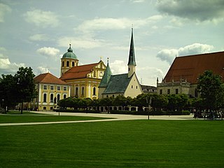
Schäftlarn is a municipality in the district of Munich in Bavaria in Germany. It consists of the villages Ebenhausen, Hohenschäftlarn, Kloster Schäftlarn, Neufahrn and Zell. The river Isar runs through it. A human settlement with the name "Schäftlarn" does not exist.

Thierhaupten is a market town in south-central Germany in the district of Augsburg (district) in the Swabia administrative region of Bavaria, and is located at the Lech Valley.

Freyung is a town in Bavaria, Germany, capital of the Freyung-Grafenau district. It is situated in the Bavarian Forest mountain range, near the border with Austria and the Czech Republic.

Schlüsselfeld is a town on the southwestern edge of the Upper Franconian district (Landkreis) of Bamberg

Aura an der Saale is a municipality in the district of Bad Kissingen in Bavaria in Germany.
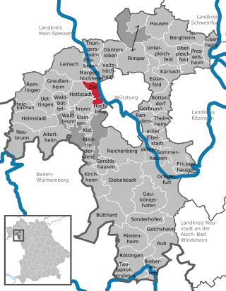
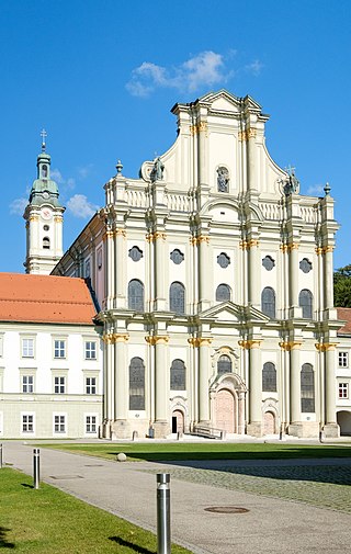
Zell am Main is a municipality in the district of Würzburg in Bavaria in Germany, situated on the river Main.

Sonnefeld is a municipality in the district of Coburg in Bavaria in Germany.

Tiefenbach is a municipality in the district of Passau in Bavaria in Germany.
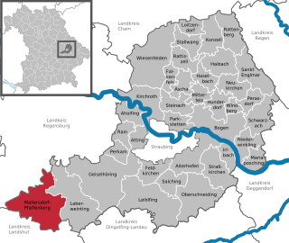
Mallersdorf-Pfaffenberg is a municipality in the district of Straubing-Bogen in Bavaria, Germany and has around 7,000 inhabitants.

Obernzell is a municipality in the district of Passau in Bavaria in Germany.

Untergriesbach is a municipality in the district of Passau in Bavaria in Germany.
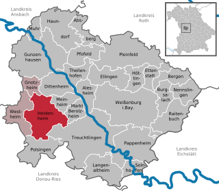
Heidenheim is a municipality in the Weißenburg-Gunzenhausen district, in Bavaria, Germany.

The St. Nikola Abbey is a former monastery of the Augustinian canons and today's mother house of the German Oratory Sisters in Passau, Lower Bavaria, Germany.


