Eket Airstrip

Last updated
Eket Airstrip
Summary
Airport type Public
Location Eket, Nigeria
Elevation  AMSL 42 ft / 13 m
Coordinates 4°38′50″N7°57′00″E / 4.64722°N 7.95000°E
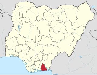
 / 4.64722; 7.95000
Map
Nigeria location map.svg
Airplane silhouette.svg
DNEK
Location of the airport in Nigeria
Runways
Direction LengthSurface
mft
01/191,3004,265Asphalt
Source: WAD [1] GCM [2] Google Maps [3]

Eket Airstrip or Eket Airfield( ICAO : DNEK) is an airport serving Eket, a city in the Akwa Ibom State of Nigeria.

ICAO airport code four-letter code designating many airports around the world

The ICAOairport code or location indicator is a four-letter code designating aerodromes around the world. These codes, as defined by the International Civil Aviation Organization and published in ICAO Document 7910: Location Indicators, are used by air traffic control and airline operations such as flight planning.

Eket LGA and town in Akwa Ibom State, Nigeria

Eket is the second largest city in Akwa Ibom State, Nigeria. The name also refers to the indigenous ethnic group of the region and to their language. The city itself, an industrial city that in recent years has become a conurbation engulfing separate villages, has a population of over 200,000, while entire urban area, which covers Okon, Nsit Ubium,Idua, Afaha Eket and Esit Eket, has a combined population of 364,489, the second largest urban population in Akwa Ibom state.

Akwa Ibom State State in Nigeria

Akwa Ibom is a state in Nigeria. It is located in the coastal southern part of the country, lying between latitudes 4°32′N and 5°33′N, and longitudes 7°25′E and 8°25′E. The state is located in the South-South geopolitical zone, and is bordered on the east by Cross River State, on the west by Rivers State and Abia State, and on the south by the Atlantic Ocean and the southernmost tip of Cross River State.

Contents

The Eket non-directional beacon (Ident:EK) is located on the field. [4] Runway length does not include a 145 metres (476 ft) displaced threshold on Runway 19.

Non-directional beacon radio transmitter which emits radio waves in all directions

A non-directional (radio) beacon (NDB) is a radio transmitter at a known location, used as an aviation or marine navigational aid. As the name implies, the signal transmitted does not include inherent directional information, in contrast to other navigational aids such as low frequency radio range, VHF omnidirectional range (VOR) and TACAN. NDB signals follow the curvature of the Earth, so they can be received at much greater distances at lower altitudes, a major advantage over VOR. However, NDB signals are also affected more by atmospheric conditions, mountainous terrain, coastal refraction and electrical storms, particularly at long range.

A displaced threshold or DTHR is a runway threshold located at a point other than the physical beginning or end of the runway.

See also

Transport in Nigeria

Decaying infrastructure is one of the deficiencies that Nigeria's National Economic Empowerment Development Strategy (NEEDS) seeks to address. The government has begun to repair the country's poorly maintained road network. Because Nigeria's railways are in a perilous condition, the government is trying to rectify the situation by privatizing the Nigerian Railway Corporation. Similarly, the government is pursuing a strategy of partial port privatization by granting concessions to private port operators so that they can improve the quality of port facilities and operations.

Related Research Articles

Coronel FAP Alfredo Mendívil Duarte Airport airport

Coronel FAP Alfredo Mendívil Duarte Airport is an airport serving Ayacucho, Peru. It is managed by CORPAC S.A., a government organization that oversees Peruvian airports. It is the main airport of the Ayacucho Region.

Benin Airport airport

Benin Airport is an airport serving Benin City, the capital of Edo State in Nigeria. The runway is in the middle of the city.

Ilorin International Airport

Ilorin International Airport is an airport serving Ilorin, a city in Kwara State of Nigeria.

Maiduguri International Airport

Maiduguri International Airport is an airport serving Maiduguri, the capital of Borno State in Nigeria.

Warri Airport

Warri Airport, also known as Osubi Airstrip, is an airport serving the city of Warri in Delta State, Nigeria. It is about 10 kilometres (6.2 mi) northeast of the city.

Minna Airport

Minna Airport is an airport 10 kilometres (6.2 mi) northwest of Minna, the capital of Niger State in Nigeria.

Francisco de Orellana Airport

Francisco de Orellana Airport is an airport serving Puerto Francisco de Orellana, the capital of Orellana Province in Ecuador.

Kidepo Airport

Kidepo Airport is an airfield in Northern Region, Uganda. The airport is at Lomej, approximately 3 kilometres (2 mi) south of the headquarters of Kidepo Valley National Park, and 456 kilometres (283 mi) northeast of Entebbe International Airport, the country’s largest civilian and military airport.

Kabale Airport

Kabale Airport is an airstrip serving Kabale, a town in the Kabale District in the Western Region of Uganda. It is one of the 46 airports in the country.

Boquerón Airport

Boquerón Airport is a private airstrip 2.2 miles (3.5 km) east-southeast of the coastal town of Boquerón in the municipality of Cabo Rojo, Puerto Rico. It is located on road PR-301, and it has a single asphalt runway.

Makurdi Airport

Makurdi Airport is an airport serving Makurdi, the capital city of Benue State in Nigeria.

Gusau Airstrip

Gusau Airstrip or Gusau Airfield is an airstrip serving Gusau, the capital city of the Zamfara State in Nigeria.

Régina Airport airport in France

Régina Airport is an airport serving Régina, a commune of French Guiana on the Approuague River. The runway lies along the west side of the village.

San Rafael Airport (Venezuela) airport in Venezuela

San Rafael Airport or Tucupita Airport is an airport serving Tucupita, the capital city of the state of Delta Amacuro in Venezuela.

Bebi Airstrip

Bebi Airport is an airport serving Bebi in the Cross River State of Nigeria. It also serves as the airport for the Obudu Mountain Resort. The runway is 18 kilometres (11 mi) east of the town of Obudu.

Mhlume Airfield

Mhlume Airfield is an airstrip serving Mhlume, an agricultural town in the Lubombo Region of Eswatini. The runway is on the northwest corner of the town.

Nsoko Airfield

Nsoko Airfield is an airstrip serving Nsoko, an agricultural village in the Lubombo Region of Eswatini. The runway is within the Nisela Game Reserve, 4 kilometres (2.5 mi) northeast of Nsoko, and 5 kilometres (3.1 mi) west of the South African border.

Siteki Airfield

Siteki Airfield is an airstrip serving Siteki, a town in the Lubombo Region of Eswatini. The runway is 2 kilometres (1.2 mi) south of the town.

Tambankulu Airfield

Tambankulu Airfield is an airstrip serving Tambankulu, in Eswatini.

Heritage Creek Airstrip Privately owned airport serving Decatur, Texas, United States

Heritage Creek Airstrip is a privately owned public airport in Rhome, Wise County, Texas, United States that also serves the city of Decatur, being located approximately 9 nautical miles (17 km) southeast of the central business district. The airport has no IATA or ICAO designation.

References

  1. Airport information from DAFIF (effective October 2006)
  2. Airport information for DNEK at Great Circle Mapper.
  3. Google Maps - Eket
  4. "SkyVector: Flight Planning / Aeronautical Charts". skyvector.com. Retrieved 2018-08-21.

The Aviation Safety Network (ASN) is a website that keeps track of aviation accidents, incidents, and hijackings. Their database contains details of over 10,700 reports. The ASN includes an aviation database with aviation investigations, news, photos, and statistics.