
Santa Clara is the capital city of the Cuban province of Villa Clara. It is centrally located in the province and Cuba. Santa Clara is the fifth-most populous Cuban city, with a population of nearly 245,959.

El Retiro is a town and municipality in Antioquia Department, Colombia. Part of the subregion of Eastern Antioquia, its population was 20,700 at the 2018 census.

Cerrejón is a large open-pit coal mine in Northern Colombia owned by Glencore. At Cerrejón, low-ash, low-sulphur bituminous coal from the Cerrejón Formation is excavated. At over 690 square kilometres (270 sq mi) the mine is one of the largest of its type, the largest in Latin America and the tenth biggest in the world. Cerrejón is divided into three sections, North Zone, Central Zone and South Zone. Total proven reserves are estimated at 503 megatonnes. In 2016, the mine produced 32,683,315 tonnes.

The Colombian railway network has a total length of 3,304 kilometres (2,053 mi). There are 150 kilometres (93 mi) of 1,435 mmstandard gauge connecting Cerrejón coal mines, Tren del Cerrejón, to the maritime port of Puerto Bolivar at Bahia Portete, and 3,154 kilometres (1,960 mi) of 3 ft narrow gauge of which 2,611 kilometres (1,622 mi) are in use. The state-owned railway company, Ferrocarriles Nacionales de Colombia, was liquidated in the 1990s. Since then passenger rail service in Colombia is provided only as tourist steam trains on the Bogotá savanna railway, now called Turistren, and between Bogotá and Zipaquirá, and a general daily passenger service around Barrancabermeja, and its surroundings, provided by Coopsercol.
Gerardo Tobar López Airport is an airport serving the Pacific coastal port of Buenaventura in the Valle del Cauca Department of Colombia. The runway is 6 kilometres (3.7 mi) south of the city.
La Chorrera Airport is an airport serving the town of La Chorrera in the Amazonas Department of Colombia.
La Pedrera Airport is an airport serving the Caquetá River town of La Pedrera in the Amazonas Department of southern Colombia.
La Macarena Airport, also known as El Refugio Airport, is an airport serving the Guayabero River town of La Macarena in the Meta Department of Colombia.

La Florida Airport is an airport serving the Pacific coast city of Tumaco in the Nariño Department of Colombia. The airport is on an island connected to the mainland through a series of bridges.

La Mina Airport, or Jorge Isaacs Airport, is an airport serving Maicao, a municipality in the La Guajira Department in Colombia. The airport is 31 kilometres (19 mi) southwest of Maicao.

San Andrés is a coral island in the Caribbean Sea. Politically part of Colombia, and historically tied to the United Kingdom, San Andrés and the nearby islands of Providencia and Santa Catalina form part of the department of San Andrés, Providencia and Santa Catalina; or The Raizal Islands. San Andrés, in the southern group of islands, is the largest of Colombia. The official languages of the department are Spanish, English, and San Andrés–Providencia Creole.
Neoptychites is an extinct ammonoid cephalopod genus from the Turonian stage of the Upper Cretaceous, with a worldwide distribution.
Morrowites, named by Cobban and Hook, 1983, is a moderate to large-sized ammonite with quadrangular to depressed whorls, broadly rounded to depressed venter, low ribs, umbilical and inner and outer ventrolateral tubercles and smooth early whorls except for occasional ribs along weak constrictions. The suture is moderately simple and has an unusually broad bifid first lateral lobe. It is so far restricted to the Lower Turonian stage, in the mid Cretaceous.

Mammites is a Late Cretaceous ammonite genus included in the acanthoceratoidean family, Acanthoceratidae, and the type genus for the subfamily Mammitinae. Mammites was named by Laube and Bruder in 1887.

Emeralds are green and sometime green with a blueish-tint precious gemstones that are mined in various geological settings. They are minerals in the beryl group of silicates. For more than 4,000 years, emeralds have been among the most valuable of all jewels. Colombia, located in northern South America, is the country that mines and produces the most emeralds for the global market, as well as the most desirable. It is estimated that Colombia accounts for 70–90% of the world's emerald market. While commercial grade emeralds are quite plentiful, fine and extra fine quality emeralds are extremely rare. Colombian emeralds over 50 carat can cost much more than diamonds of the same size.
Fundo Loma Larga Airport Spanish: Aeropuerto Fundo Loma Larga, is an airport serving the Loma Larga winery 5 kilometres (3.1 mi) north of Casablanca, a city in the Valparaíso Region of Chile.
Quitmaniceras is a genus of small, compressed, fairly evolute ammonites from the lower Turonian of Grant County, New Mexico and Trans-Pecos Texas, included in the subfamily Acanthoceratinae. The shell has a carinate venter in juveniles and one that is arched in adults, usually with a raised siphonal line,(siphonal referring to the marginal siphuncle). Ribs are very weak to moderately strong, flexious, typically sloping forward toward the rim, bending further forward at the outer shoulder.
Calenturitas Airport is an airport serving the Calenturitas coal mine and the town of La Loma in the Cesar Department of Colombia. The runway is adjacent to the surface mine, 10 kilometres (6.2 mi) northeast of La Loma.
The Otú Norte or Otú-Pericos Fault is an inactive sinistral oblique strike-slip fault in the department of Antioquia in northern Colombia. The fault has a total length of 144.4 kilometres (89.7 mi) and runs along an average north-northwest to south-southeast strike of 346.4 ± 8, cross-cutting the northern part of the Central Ranges of the Colombian Andes. Together with the parallel Bagre Norte Fault the fault separates the Central Ranges from its northeasternmost continuation, the Serranía de San Lucas.
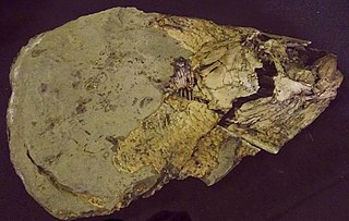
Bachea is an extinct genus of ray-finned fish that lived during the Late Cretaceous in what is now central Colombia, South America. The type species is Bachea huilensis, described in 1997 by María Páramo from the Turonian of Huila, Colombia.
