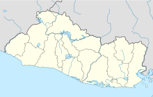
Ilopango is a town in the San Salvador department of El Salvador. It is a few miles east of the nation's capital, San Salvador. It is located near Lake Ilopango, the country's largest lake at 72 square kilometers.
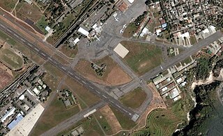
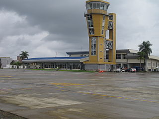
Ilopango International Airport is an airport located on the eastern part of the city of San Salvador, El Salvador, once serving the city as its international airport until it was replaced by the larger and more modern Comalapa International Airport, located about 50 km south of the city. Currently, Ilopango is used for military, air taxi, and charter aviation only. It also holds the annual Ilopango Air Show. The airport is also home to the National Aviation Museum of San Salvador, which is housed in the old terminal building.

El Loa Airport, is the major airport serving Calama, a city in the Antofagasta Region of Chile. It is one of the largest airports in Chile.
Ricardo García Posada Airport, formerly El Salvador Bajo Airport, is an airport serving the copper mining community of El Salvador, in the Atacama Region of Chile.
El Caraño Airport is an airport serving Quibdó in the Chocó Department of Colombia.
The Civil Aviation Authority is the civil aviation agency of El Salvador. The agency conducts investigations into aviation accidents and incidents. The agency is headquartered in Ilopango Airport in Ilopango, San Salvador Department. Honduran authorities delegated the investigation of the TACA Flight 390 incident to the Salvadoran Civil Aviation Authority as per the Convention on International Civil Aviation.
El Mirador Airport, is an airport just southeast of Puerto Varas, a city in the Los Lagos Region of Chile. Puerto Varas is on the southwest shore of Llanquihue Lake.

El Porvenir Airport is an airport serving El Porvenir, in Panama. The airport is on an island 2 kilometres (1.2 mi) east of the mainland, in the archipelago bordering the Gulf of San Blas. All approaches and departures will be over the water.
El Real de Santa María Airport is an airstrip serving the small town of El Real de Santa María, in the Darién Province of Panama. El Real is 6.5 kilometres (4.0 mi) southwest of Yaviza, the southern end of the North American section of the Pan American Highway. There are no paved roads between the two towns.

Erandique Airport is an airstrip serving the town of Erandique in Lempira Department, Honduras.
Nueva Ocotepeque Airport is an airport serving the town of Nueva Ocotepeque in Ocotepeque Department, Honduras. Nueva Ocotepeque is in a north-south valley 5 kilometres (3.1 mi) north of the El Salvador border, and 13 kilometres (8.1 mi) east of the Guatemala border.

Barrillas Airport is an airport serving Puerto Barillas, a small-craft dockage on an arm of the Bahia de Jiquilisco, 10 kilometres (6.2 mi) southwest of Usulután in Usulután Department, El Salvador.
Ceiba Doblada Airport is an airstrip serving the village of Ceiba Doblada in Usulután Department, El Salvador. The unmarked grass runway is 8 kilometres (5.0 mi) east of the village.
Corral De Mulas Airport is an airport serving the village of Corral De Mulas in Usulután Department, El Salvador. The unmarked grass runway is west of and adjacent to the village.
Punta San Juan Airport is an airport serving the village of Corral De Mulas in Usulután Department, El Salvador. The unmarked grass runway is 7 kilometres (4.3 mi) east of the village on Punta San Juan, the western shore of the entrance to Bahia de Jiquilisco. Corral de Mulas is also served by Corral de Mulas Airport.
Los Comandos Airport is an airstrip serving the town of San Francisco Gotera in Morazán Department, El Salvador.
Espiritu Santo Airport is an airstrip serving the village of Espiritu Santo in Usulután Department, El Salvador. The runway is on a point in the Bahia de Jiquilisco.
La Cabaña Airport is an airstrip serving the town of La Cabaña in San Salvador Department, El Salvador.
La Chepona Airport is an airstrip serving the village of La Chepona in Usulután Department, El Salvador. The airstrip and village are on an estuarian island just east of the Jiquilisco Bay.
Las Cachas Airport is an airstrip serving the hamlet of Cangrejera in La Libertad Department, El Salvador.