La Aurora International Airport serves Guatemala City, Guatemala. It is located 6.4 km (4.0 mi) south of Guatemala City's center and 25 km (16 mi) from Antigua Guatemala. It is administered by the Dirección General de Aeronáutica Civil.
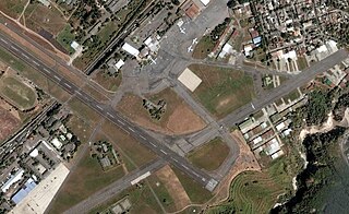
Ilopango International Airport is an airport located on the eastern part of the city of San Salvador, El Salvador, once serving the city as its international airport until it was replaced by the larger and more modern Comalapa International Airport, located about 50 km south of the city. Currently, Ilopango is used for military, air taxi, and charter aviation only. It also holds the annual Ilopango Air Show. The airport is also home to the National Aviation Museum of San Salvador, which is housed in the old terminal building.
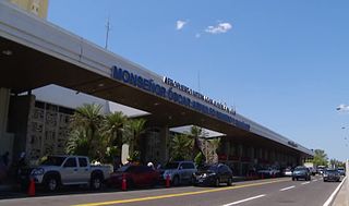
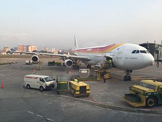
Monseñor Óscar Arnulfo Romero International Airport, previously known as Comalapa International Airport ; previous Official name El Salvador International Airport. is an airport located about 50 km (31 mi) from San Salvador in El Salvador. With 2,984,746 passengers in 2016, it is the busiest airport in El Salvador and third-busiest in Central America by passenger traffic.
Ricardo García Posada Airport, formerly El Salvador Bajo Airport, is an airport serving the copper mining community of El Salvador, in the Atacama Region of Chile.

TACA Flight 390 was a scheduled flight on May 30, 2008, by TACA Airlines from San Salvador, El Salvador, to Miami, Florida, United States, with intermediate stops at Tegucigalpa and San Pedro Sula in Honduras. In this hull loss/fatalities accident, the Airbus A320-233 overran the runway after landing at Tegucigalpa's Toncontín International Airport and rolled out into a street, crashing into an embankment and smashing several cars in the process.

El Tamarindo Airport is an airport serving El Tamarindo, a coastal town in the La Unión Department of El Salvador.

Aviateca Flight 901 was a Boeing 737-200 that crashed into the San Vicente volcano in El Salvador on approach to the airport on 9 August 1995. The accident killed all 65 passengers and crew on board.
Ceiba Doblada Airport is an airstrip serving the village of Ceiba Doblada in Usulután Department, El Salvador. The unmarked grass runway is 8 kilometres (5.0 mi) east of the village.
Punta San Juan Airport is an airport serving the village of Corral De Mulas in Usulután Department, El Salvador. The unmarked grass runway is 7 kilometres (4.3 mi) east of the village on Punta San Juan, the western shore of the entrance to Bahia de Jiquilisco. Corral de Mulas is also served by Corral de Mulas Airport.
Casas Nuevas Airport is an airstrip serving the city of Jiquilisco in Usulután Department, El Salvador. The unmarked grass runway is 7 kilometres (4.3 mi) east of the city.
Los Comandos Airport is an airstrip serving the town of San Francisco Gotera in Morazán Department, El Salvador.
Santa Rosa de Lima Airport is an airport serving the city of Santa Rosa de Lima in La Unión Department, El Salvador. The runway is 3 kilometres (1.9 mi) east of the city.
El Platanar Airport is an airport serving the town of El Platanar in San Miguel Department, El Salvador. The runway is 1 kilometre (0.6 mi) northwest of the city.
Espiritu Santo Airport is an airstrip serving the village of Espiritu Santo in Usulután Department, El Salvador. The runway is on a point in the Bahia de Jiquilisco.
El Zapote Airport is an airport serving the village of El Zapote in Ahuachapán Department, El Salvador. The runway is on a point in the Bahia de Jiquilisco.
La Cabaña Airport is an airstrip serving the town of La Cabaña in San Salvador Department, El Salvador.
La Carrera Airport is an airport serving the city of Jiquilisco in Usulután Department, El Salvador. The runway is 5 kilometres (3.1 mi) east of Jiquilisco.
Usulután Airport is an airstrip serving the city of Usulután in Usulután Department, El Salvador. It is 6 kilometres (3.7 mi) west of the city on highway CA2E. There is a hangar and fueling tank next to the north end of the runway.