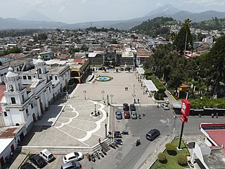
Chimaltenango is a city in Guatemala with a population of 96,985. It serves as both the capital of the department of Chimaltenango and the municipal seat for the surrounding municipality of the same name. Chimaltenango stands some 56 kilometres (35 mi) west of Guatemala City, on the Pan-American Highway. The municipal capital produces textiles and pottery.

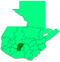
Chimaltenango is a department of Guatemala. The capital is Chimaltenango.

San Pedro Carchá, usually referred to as Carchá, is a town and a municipality in the Guatemalan department of Alta Verapaz. The municipality covers an area of 1,310 km2 (510 sq mi) and is situated at 1,282 m above sea level.

Jocotenango is a town and small municipality in the northeast section of Guatemalan department of Sacatepéquez, and is situated north of Antigua Guatemala. It has seven zones, two villages, and one hamlet. According to the 2018 census, the municipality has a total population of 21,657 of which 1,680 are native population and the balance are non-indigenous; and approximately 19,280 live in an urban area, while the balance are rural dwellers.

Santiago Sacatepéquez is a town, with a population of 24,100, and a municipality in the Guatemalan department of Sacatepéquez. It is well known for a kite festival held here annually on November 1.
Nentón is a town and municipality in the Guatemalan department of Huehuetenango. Its territory extends 717 km2 with a population of 45,679. It became a municipality on December 5, 1876 and was formerly known as San Benito Nentón. The population speaks Spanish and Chuj.
Acatenango is a town and municipality in the Chimaltenango department of Guatemala. It is in this municipality that the Acatenango volcano is located. The town is in the valley of the Cocoyá River.

San Juan Comalapa is a town, with a population of 32,312, and a municipality in the Chimaltenango department of Guatemala.

Patzún is a town, with a population of 26,632 and a municipality in the Chimaltenango department of Guatemala.
San Andrés Itzapa is a town, with a population of 24,992, and a municipality of Chimaltenango, Guatemala. San Andrés Itzapa is in the eastern region of Chimaltenango, while the district capital lies to the north, Acatenango lies to the south and to the east is Parramos. The municipality cover an area of 63.7 km2, with a total population of 32,083.
San Martín Jilotepeque is a town, with a population of 10,812, and a municipality in the Chimaltenango department of Guatemala. It was the site of a bus accident in 2013.
Tecpán is a town, with a population of 34,519, and a municipality in the department of Chimaltenango, in Guatemala, on the Inter-American Highway CA-1.
Yepocapa, also known as San Pedro Yepocapa, is a town with a population of 17,021, and a municipality in the Chimaltenango department of Guatemala. It is located at the base of Volcán de Fuego, which has destroyed the town several times, most recently on 15 October 1974.
Zaragoza is a town, with a population of 11,176, and a municipality in the Chimaltenango department of Guatemala.
San Miguel Chicaj is a town and municipality in the Baja Verapaz department of Guatemala. San Miguel Chicaj has an area of 280 Km², which makes one of the largest municipality of Baja Verapaz Department. It has a population of 33,131, mostly of achí background.

Santa Catarina Pinula is a town, with a population of 70,982 and a municipality in the Guatemala Department of Guatemala.
Moyuta is a town and municipality in the Jutiapa department of Guatemala.

San Juan Ostuncalco, is a town, with a population of 20,763, and a municipality in the Quetzaltenango department of Guatemala. Beside Spanish, local people speak the Mam language.
El Quetzal is a town and municipality in the San Marcos department of Guatemala. It was recognised as municipality on 19 June 1900. The major source of income is the agriculture.
Barberena is a town, with a population of 47,093, and a municipality in Santa Rosa department of Guatemala. Filled with local vendors and stores selling American goods, Barberena is a small town typical of the Guatemalan countryside.