Yepocapa

Last updated • 4 min readFrom Wikipedia, The Free Encyclopedia
San Pedro Yepocapa
Apocapa
Yepocapa
Municipality and town of Guatemala
Guatemala location map.svg
Red pog.svg
San Pedro Yepocapa
Chimaltenango department location map.svg
Red pog.svg
San Pedro Yepocapa
Coordinates: 14°30′N90°57′W / 14.500°N 90.950°W / 14.500; -90.950
CountryFlag of Guatemala.svg  Guatemala
Department Vlagchimaltenango.gif Chimaltenango
Government
  TypeMunicipal
  Mayor (2016-2020)Bernabé Ajín Vicente [1]
Area
[2]
  Total
83 sq mi (214 km2)
Elevation
4,600 ft (1,400 m)
Population
 (2018 census) [3]
  Total
34,948
  Density420/sq mi (160/km2)
Time zone UTC+6 (Central Time)
Climate Am

Yepocapa, also known as San Pedro Yepocapa, is a town with a population of 17,021 (2018 census), [4] and a municipality in the Chimaltenango department of Guatemala. It is located at the base of Volcán de Fuego, which has destroyed the town several times, most recently on 15 October 1974. [5]

Contents

History

San Pedro Yepocapa has its origins in the times before the Spanish conquest of Guatemala; originally the town was right next to Volcán de Fuego, but it had to be moved to a different location because of the numerous eruptions of it. Spanish soldier Antonio de Guzmán is credited with being the one that found the town when the conquistadors arrived in the 1520s.

Spanish colony: Franciscan doctrine

After the Spanish conquest of Guatemala the town was in charge of the franciscans, who had convents and doctrines in the area covered by the modern departments of Sacatepéquez, Chimaltenango, Sololá, Quetzaltenango, Totonicapán, Suchitepéquez and Escuintla. The "Provincia del Santísimo Nombre de Jesús" (English:"Province of the most Holy Name of Jesus"), as the Franciscan area was then called, reached up to 24 convents by 1700. [6]

The Franciscans tried to have daily religious teaching for 6-year-old girls and older starting at 2:00 pm and for boys of the same age starting at sunset; the class lasted for 2 hours and consisted on memorizing the church teaching and prayers and to make some exercises with the catechism and it was run by a priest or by elder natives, called "fiscales". [7] Adults attended Mass every Sunday and holiday and after mass, there were religious teachings in their own language. [7]

Lent was a time of the year when the friars prepared the natives thoroughly, using their own language to accomplish their goals; every Friday of Lent there was a procession following the Rosary steps all the way to the Calvary temple. [8]

A document from Franciscan friar Francisco de Zuaza written on 8 July 1686, found in the Archdiocese of Guatemala archives and made public in 1944, describes Franciscan convents and doctrines in Guatemala and regarding the Acatenango convent says: "There is another visit town, named San Pedro Yepocapa, which is 16 km from the convent, on the way to the sea shore, on badly maintained road. The temperature of this town is warm because it is close to the coast". [9]

In 1754, as part of the borbon reforms, the Franciscans where forced to giae their doctrines to the secular clergy. [10]

After independence from Spain

When the State of Guatemala was created on 11 October 1825, after independence from Spain, San Pedro Yepocapa was established as town, and then was raised to a municipality of the Chimaltenango District by a decree from 12 September 1839. [9] By 1880 already had a population a little over a thousand focused mainly on agricultural activities.

1974 Volcán de Fuego eruption

The 1974 Volcan de Fuego eruption partially destroyed San Pedro Yepocapa. Volcan de Fuego pyroclastic flows - october 1974 eruption.jpg
The 1974 Volcán de Fuego eruption partially destroyed San Pedro Yepocapa.
Guatemala location map.svg
Red pog.svg
San Pedro Yepocapa
Towns impacted by the 1974 eruption. [5]

On 15 October 1974, tremors woke up people in the settlements surrounding the Volcán de Fuego at 2:00 AM, followed by rumbling and cinders and ashes falling from the sky, which submerged the town into darkness for a few days. President Kjell Eugenio Laugerud García gave order to evacuate people, most of whom were sorry about losing all of their belongings after the eruption; in the meantime, ash was travelling as far away s the Mexican states of Chiapas and Oaxaca, to the point that Mexican authorities were on alert due to the amounts of it that they were getting. [5]

San Pedro Yepocapa was one of the most impacted towns, ending under more than 1m of ash after the four days that the eruption lasted; approximately 1100 people from Morelia hacienda and annexes had to be evacuated to temporary shelters in neighboring Santa Lucía Cotzumalguapa, Escuintla or Patulul, Suchitepéquez. [11]

Democracia Cristiana Guatemalteca —DCG— directors -then the main opposition party in the country after losing the presidency to Laugerud Garcia in fraudulent elections earlier that year , [12] asked to all the mayors to help their colleagues from San Pedro Yepocapa and Acatenango, which were practically destroyed by the catastrophe; those two mayor belonged to DCG. Help began to arrive on 24 October 1974, when the eruption ceased and equipment from the Road General Direction of Guatemala arrived to the towns to clean them up, and operation that lasted three months. [5]

Climate

San Pedro Yepocapa has a tropical monsoon climate (Köppen: Am).

Climate data for Acatenango
MonthJanFebMarAprMayJunJulAugSepOctNovDecYear
Mean daily maximum °C (°F)25.5
(77.9)
25.9
(78.6)
26.8
(80.2)
26.7
(80.1)
26.4
(79.5)
25.3
(77.5)
25.6
(78.1)
25.7
(78.3)
25.0
(77.0)
24.8
(76.6)
25.3
(77.5)
25.0
(77.0)
25.7
(78.2)
Daily mean °C (°F)19.5
(67.1)
19.7
(67.5)
20.6
(69.1)
21.0
(69.8)
21.2
(70.2)
21.0
(69.8)
20.9
(69.6)
20.8
(69.4)
20.3
(68.5)
20.0
(68.0)
19.9
(67.8)
19.2
(66.6)
20.3
(68.6)
Mean daily minimum °C (°F)13.5
(56.3)
13.6
(56.5)
14.4
(57.9)
15.4
(59.7)
16.0
(60.8)
16.7
(62.1)
16.2
(61.2)
16.0
(60.8)
15.7
(60.3)
15.3
(59.5)
14.6
(58.3)
13.5
(56.3)
15.1
(59.1)
Average precipitation mm (inches)8
(0.3)
18
(0.7)
29
(1.1)
65
(2.6)
209
(8.2)
494
(19.4)
324
(12.8)
345
(13.6)
534
(21.0)
302
(11.9)
60
(2.4)
13
(0.5)
2,401
(94.5)
Source: Climate-Data.org [13]

Geographic location

See also

Notes and references

    Related Research Articles

    <span class="mw-page-title-main">Chimaltenango</span> Municipality and city in Guatemala

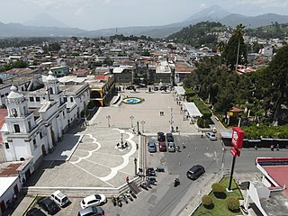
    Chimaltenango is a city in Guatemala with a population of 96,985. It serves as both the capital of the department of Chimaltenango and the municipal seat for the surrounding municipality of the same name. Chimaltenango stands some 56 kilometres (35 mi) west of Guatemala City, on the Pan-American Highway. The municipal capital produces textiles and pottery.

    <span class="mw-page-title-main">Escuintla</span> Municipality in Guatemala

    Escuintla is an industrial city in Guatemala, its land extension is 4,384 km2, and it is nationally known for its sugar agribusiness. Its capital is a municipality with the same name. Citizens celebrate from December 6 to 9 with a small fair in honor to The Immaculate Conception.

    <span class="mw-page-title-main">Chimaltenango Department</span> Department of Guatemala

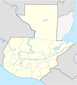
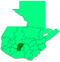
    Chimaltenango is a department of Guatemala. The capital is Chimaltenango.

    <span class="mw-page-title-main">Volcán de Agua</span> Stratovolcano in Guatemala

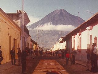
    Volcán de Agua is an extinct stratovolcano located in the departments of Sacatepéquez and Escuintla in Guatemala. At 3,760 m (12,340 ft), Agua Volcano towers more than 3,500 m (11,500 ft) above the Pacific coastal plain to the south and 2,000 m (6,600 ft) above the Guatemalan Highlands to the north. It dominates the local landscape except when hidden by cloud cover. The volcano is within 5 to 10 km of the city of Antigua Guatemala and several other large towns situated on its northern apron. These towns have a combined population of nearly 100,000. It is within about 20 km (12 mi) of Escuintla to the south. Coffee is grown on the volcano's lower slopes.

    <span class="mw-page-title-main">Volcán de Fuego</span> Volcano in Guatemala

    Volcán de Fuego or Chi Q'aq' is an active stratovolcano in Guatemala, on the borders of Chimaltenango, Escuintla and Sacatepéquez departments.

    <span class="mw-page-title-main">Panajachel</span> City and municipality in Sololá, Guatemala

    Panajachel is a town in the southwestern Guatemalan Highlands, less than 140 kilometres (90 mi) from Guatemala City, in the department of Sololá. It serves as the administrative centre for the surrounding municipality of the same name. The elevation is 1,597 metres (5,240 ft). Population was 11 thousand in the 2000 census, projected as 15,830 by June 30, 2020 and has approximately doubled each of the last few decades. The town of Panajachel is located on the Northeast shore of Lake Atitlán, and has become a centre for the tourist trade of the area as it provides a base for visitors crossing the lake to visit other towns and villages.

    <span class="mw-page-title-main">Alotenango</span> Municipality and town in Sacatepéquez, Guatemala

    Alotenango is a town and municipality in the Guatemalan department of Sacatepéquez. According to the 2018 census, the town has a population of 23,358. The municipality consists of four wards and is situated on the Escuintla road. Located in a valley, Alotenango is a Ladino coffee center, since the times of general Justo Rufino Barrios liberal regime (1873–1885).

    <span class="mw-page-title-main">Santiago Sacatepéquez</span> Municipality in Sacatepéquez Department, Guatemala

    Santiago Sacatepéquez is a town, with a population of 24,100, and a municipality in the Guatemalan department of Sacatepéquez. It is well known for a kite festival held here annually on November 1.

    <span class="mw-page-title-main">Chiantla</span> Municipality in Huehuetenango, Guatemala

    Chiantla is a town and municipality in the Guatemalan department of Huehuetenango. The municipality is situated at 2,000 metres above sea level and covers an area of 521 km2. The annual festival is on January 28.

    <span class="mw-page-title-main">Jacaltenango</span> Municipality in Huehuetenango, Guatemala

    Jacaltenango is a town and municipality situated in the Western Highlands of Guatemala. It is located in a valley surrounded by the Sierra Madre Mountains. Jacaltenango serves as the municipal seat for the surrounding municipality of the same name. In 2002, its urban population was about 23,500 but at the 2018 census the town's population has decreased to 22,533.

    <span class="mw-page-title-main">San Pedro Soloma</span> Municipality in Huehuetenango, Guatemala

    San Pedro Soloma is a town and municipality of Huehuetenango, a department of Guatemala. It is located in the Sierra de los Cuchumatanes at 2,300 m above sea level. The municipality covers a total area of 264 km2 with elevations ranging from 1,900 m to 3,500 m. Its population of 49,030 is spread over the town of Soloma, 19 villages and 50 smaller rural communities (caserios).

    Acatenango is a town and municipality in the Chimaltenango department of Guatemala. It is in this municipality that the Acatenango volcano is located. The town is in the valley of the Cocoyá River.

    <span class="mw-page-title-main">San Juan Comalapa</span> Municipality and town in Chimaltenango, Guatemala

    San Juan Comalapa is a town, with a population of 32,312, and a municipality in the Chimaltenango department of Guatemala.

    <span class="mw-page-title-main">San Juan Ostuncalco</span> Municipality and town in Quetzaltenango, Guatemala

    San Juan Ostuncalco, is a town, with a population of 20,763, and a municipality in the Quetzaltenango department of Guatemala. Beside Spanish, local people speak the Mam language.

    Malacatán is a town and municipality in the San Marcos department of Guatemala, located to the west of San Marcos town. It is fairly close to the border with Mexico - the border-crossing point is in the nearby village of El Carmen.

    <span class="mw-page-title-main">San Antonio Palopó</span> Municipality and village in Sololá, Guatemala

    San Antonio Palopó is a municipality in the Sololá Department of Guatemala. The village is on the eastern shore of Lake Atitlán. The lowest elevation is 1,562 metres (5,125 ft) at the shoreline. The people of the region are Cakchiquel Maya with a distinctive style of clothing. The patron saint of the village is St. Anthony of Padua. The annual festival takes place on 13 June.

    <span class="mw-page-title-main">San Lucas Tolimán</span> Municipality of Guatemala in Sololá

    San Lucas Tolimán is a municipality in the Sololá department of Guatemala. The town of 17,000 people sits on the southeastern shore of Lago de Atitlán. The population is 90–95% Highland Maya. There is a population of about the same size living in the surrounding villages.

    The Río Pantaleón is a river in the south of Guatemala. Its sources are located in the Sierra Madre mountain range, on the western slopes of the Volcán de Fuego in the departments of Chimaltenango and Escuintla. The river flows in a south-westerly direction through the coastal lowlands of Escuintla where it joins the San Cristobal River, a tributary of the Coyolate River.

    <span class="mw-page-title-main">2018 Volcán de Fuego eruption</span> Volcanic eruption in Guatemala

    The 2018 Volcán de Fuego eruption was an eruption of Volcán de Fuego in Guatemala on Sunday 3 June 2018. The eruption produced a large ash plume fed by continuous explosions, pyroclastic flows, and lahars. Pyroclastic flows descended the Las Lajas ravine and overspilled its confines, causing the death of officially nearly 200 people. This was the deadliest eruption in Guatemala since the eruption of Volcán Santiaguito in 1902.

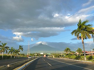
    El Rodeo is a town in the Escuintla Department of Guatemala, about 35 kilometers southwest of Guatemala City. It is located at an altitude of 2,483 m (8,146 ft) above sea level on the southern slopes of an active volcano called Volcán de Fuego — Spanish for Volcano of Fire.

    References

    1. "Alcaldes electos en el departamento de Chimaltenango". Municipalidades de Guatemala (in Spanish). Guatemala. 8 September 2015. Archived from the original on October 2, 2015. Retrieved 2 October 2015.
    2. "San Pedro Yepocapa". Chimaltenango.org (in Spanish). Guatemala. 2010. Archived from the original on February 4, 2013. Retrieved 16 October 2015.
    3. Citypopulation.de Population of departments and municipalities in Guatemala
    4. Citypopulation.de Population of cities & towns in Guatemala
    5. 1 2 3 4 Prensa Libre 2015 , p. 1
    6. García Añoveros 1989 , p. 891
    7. 1 2 García Añoveros 1989 , p. 896
    8. García Añoveros 1989 , p. 897
    9. 1 2 "Historia de San Pedro Yepocapa". De Guate (in Spanish). Guatemala. Retrieved 16 October 2015.
    10. Juarros 1818, p. 338.
    11. Prensa Libre 1974 , p. 1
    12. Elías 2009.
    13. "Climate: Yepocapa". Climate-Data.org. Retrieved 15 October 2015.
    14. 1 2 "Municipios del departamento de Chimaltenango". SEGEPLAN (in Spanish). Guatemala. Archived from the original on 7 July 2015. Retrieved 22 July 2015.

    Bibliography

    14°30′N90°57′W / 14.500°N 90.950°W / 14.500; -90.950