Elbtal

Last updated
Elbtal
DEU Elbtal Banner.svg
DEU Elbtal (Hessen) COA.svg
Location of Elbtal within Limburg-Weilburg district
Elbtal in LM.svgDornburgElzSeltersWaldbrunn
Germany adm location map.svg
Red pog.svg
Elbtal
Hesse location map.svg
Red pog.svg
Elbtal
Coordinates: 50°31′N08°04′E / 50.517°N 8.067°E / 50.517; 8.067
Country Germany
State Hesse
Admin. region Gießen
District Limburg-Weilburg
Government
   Mayor (202026) Joachim Lehnert [1] (Ind.)
Area
  Total11.12 km2 (4.29 sq mi)
Elevation
259 m (850 ft)
Population
 (2022-12-31) [2]
  Total2,441
  Density220/km2 (570/sq mi)
Time zone UTC+01:00 (CET)
  Summer (DST) UTC+02:00 (CEST)
Postal codes
65627
Dialling codes 06436
Vehicle registration LM
Website gemeinde-elbtal.de

Elbtal is a municipality in Limburg-Weilburg district in Hesse, Germany.

Contents

Geography

Location

Elbtal lies on the Westerwald’s southern slope above the Lahn valley.

Constituent communities

Elbtal’s Ortsteile are Dorchheim (administrative seat), Elbgrund, Hangenmeilingen, und Heuchelheim.

History

The hills on either side of the Elbbach were already inhabited by the New Stone Age, as shown by the many finds of stone tools. The circular rampart called Heidenhäuschen ("Little Heath House") near Hangenmeilingen has been dated to Hallstatt times (750 to 450 BC).

Heuchelheim had its first documentary mention in 772 in a donation document from the Lorsch Abbey. Waldmannshausen, one of Elbgrund’s forerunner communities, had its first documentary mention on 21 October 1138 in connection with its donation to the monastery at St. Goar. Dorchheim had its first documentary mention in 1215 in a document from the Maria Laach Abbey while Mühlbach, Elbgrund’s other forerunner community, was first mentioned in 1230 in a donation by the House of Nassau to the Teutonic Knights. Hangenmeilingen had its first documentary mention on 21 January 1333.

The still preserved moated castle of Waldmannshausen in Elbgrund was in the Middle Ages the seat of the Walpode, who held the judiciary overlordship in the surrounding country. The building work comprises a Late Gothic dwelling house with two round towers and commercial buildings, which are still used today. To the west are found the ruins of an older, cross-shaped castle. In 1835, the castle came into the prominent Bethmann banking family’s ownership. After the Second World War, it was quarters for the United States Army. Today its use is scholastic.

One of the oldest buildings in the community is the Marienstätter Hof in Dorchheim, which has been used since 1993 as Elbtal’s town hall. Its exact building year is unknown. It is one of three still preserved estates that belonged to Marienstatt Abbey.

Until the mid 20th century, clay and basalt were quarried in Mühlbach’s municipal area.

On 1 February 1971, the communities of Dorchheim, Hangenmeilingen and Heuchelheim merged into one with the name Elbtal. On 1 July 1973, the then still autonomous community of Elbgrund also joined, after itself having been formed in a merger in 1936 of the formerly autonomous communities of Mühlbach and Waldmannshausen.

Politics

Elbtal Town Hall in Dorchheim Elbtal Rathaus.jpg
Elbtal Town Hall in Dorchheim

Community council

The municipal election held on 26 March 2006 yielded the following results:

Parties and voter communities%
2006
seats
2006
%
2001
seats
2001
CDU Christian Democratic Union of Germany 43.2741.36
SPD Social Democratic Party of Germany 27.1425.34
FWG Freie Wählergemeinschaft Elbtal13.5213.82
FBHFreie Bürgerliste Hangenmeilingen9.4110.02
BLDBürgerliste Dorchheim6.819.61
Total100.015100.015
voter turnout in %45.657.0

Sightseeing

Built in the early 12th century and converted in the 16th century, it has central pillars with rich carving and a sanctuary with a painting gallery.

Economy and infrastructure

Elbtal is a residential community. Besides the trades and crafts that are customary in such a place, there is no industry.

Transport

The community lies on Bundesstraße 54 (Siegen - Limburg) and is thereby well linked to the long-distance road network.

Education

The Elbtalschule in Dorchheim serves as a common primary school for the community. Nearby secondary schools are the Mittelpunktschule St. Blasius in Frickhofen and the Fürst Johann Ludwig Schule in Hadamar.

Public institutions

Related Research Articles

<span class="mw-page-title-main">Limburg an der Lahn</span> Town in Hesse, Germany

Limburg an der Lahn is the district seat of Limburg-Weilburg in Hesse, Germany.

<span class="mw-page-title-main">Leun</span> Town in Hesse, Germany

Leun is a small town in the Lahn-Dill-Kreis in Hesse, Germany.

<span class="mw-page-title-main">Selters (Taunus)</span> Municipality in Hesse, Germany

Selters (Taunus) is a municipality with 8,000 inhabitants north of Bad Camberg in Limburg-Weilburg district in Hesse, Germany.

<span class="mw-page-title-main">Merenberg</span> Municipality in Hesse, Germany

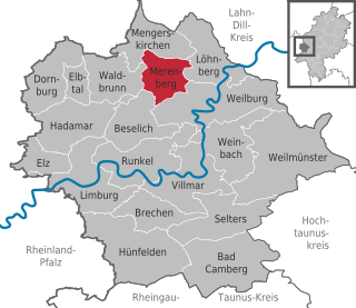
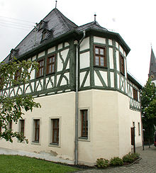
Merenberg is a municipality in Limburg-Weilburg district in Hesse, Germany.

<span class="mw-page-title-main">Hadamar</span> Town in Hesse, Germany

Hadamar is a small town in Limburg-Weilburg district in Hesse, Germany.

<span class="mw-page-title-main">Hünfelden</span> Municipality in Hesse, Germany

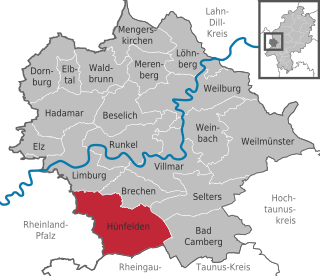
Hünfelden is a municipality in Limburg-Weilburg district in Hesse, Germany. Hünfelden lies on the Hühnerstraße, an historic part of Bundesstraße 417.

<span class="mw-page-title-main">Weinbach</span> Municipality in Hesse, Germany

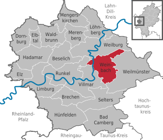
Weinbach is a municipality in Limburg-Weilburg district in Hesse, Germany.

<span class="mw-page-title-main">Runkel</span> Town in Hesse, Germany

Runkel is a town on the river Lahn in Limburg-Weilburg district in Hesse, Germany.

<span class="mw-page-title-main">Weilmünster</span> Municipality in Hesse, Germany

Weilmünster is a municipality in Limburg-Weilburg district in Hesse, Germany.

<span class="mw-page-title-main">Beselich</span> Municipality in Hesse, Germany

Beselich is a municipality in Limburg-Weilburg district in Hesse, Germany.

<span class="mw-page-title-main">Abtsteinach</span> Municipality in Hesse, Germany

Abtsteinach is a municipality in the Bergstraße district in Hesse, Germany. The municipality calls itself “The Gateway to the Überwald”.

<span class="mw-page-title-main">Brechen</span> Municipality in Hesse, Germany

Brechen is a municipality in Limburg-Weilburg district in Hesse, Germany.

<span class="mw-page-title-main">Löhnberg</span> Municipality in Hesse, Germany

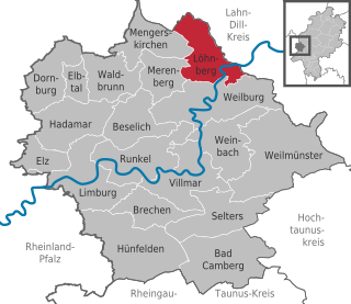
Löhnberg is a municipality north of Weilburg in Limburg-Weilburg district in Hesse, Germany.

<span class="mw-page-title-main">Neuenstein, Hesse</span> Municipality in Hesse, Germany

Neuenstein is a municipality in the Hersfeld-Rotenburg district of northeastern Hesse, Germany.

<span class="mw-page-title-main">Dornburg, Hesse</span> Municipality in Hesse, Germany

Dornburg is a municipality in the Westerwald in Limburg-Weilburg district in Hesse, Germany.

<span class="mw-page-title-main">Mengerskirchen</span> Municipality in Hesse, Germany

Mengerskirchen is a municipality in Limburg-Weilburg district in Hesse, Germany.

<span class="mw-page-title-main">Villmar</span> Municipality in Hesse, Germany

Villmar is a market village and municipality in the Limburg-Weilburg district in Hesse, Germany. The community is the centre for quarrying and processing the so-called Lahn Marble.

<span class="mw-page-title-main">Waldbrunn, Hesse</span> Municipality in Hesse, Germany

Waldbrunn (Westerwald) is a municipality in Limburg-Weilburg district in Hesse, Germany.

<span class="mw-page-title-main">Hohenstein, Hesse</span> Municipality in Hesse, Germany

Hohenstein is a municipality in the Rheingau-Taunus-Kreis in the Regierungsbezirk of Darmstadt in Hesse, Germany.

References

  1. "Ergebnisse der letzten Direktwahl aller hessischen Landkreise und Gemeinden" (XLS) (in German). Hessisches Statistisches Landesamt. 5 September 2022.
  2. "Bevölkerung in Hessen am 31.12.2022 nach Gemeinden" (XLS) (in German). Hessisches Statistisches Landesamt. June 2023.