Brechen

Last updated
Brechen
Wappen Brechen.png
Location of Brechen within Limburg-Weilburg district
Brechen in LM.svgDornburgElzSeltersWaldbrunn
Germany adm location map.svg
Red pog.svg
Brechen
Hesse location map.svg
Red pog.svg
Brechen
Coordinates: 50°21′N08°11′E / 50.350°N 8.183°E / 50.350; 8.183 Coordinates: 50°21′N08°11′E / 50.350°N 8.183°E / 50.350; 8.183
Country Germany
State Hesse
Admin. region Gießen
District Limburg-Weilburg
Government
   Mayor (202228) Frank Groos [1] (Ind.)
Area
  Total24.86 km2 (9.60 sq mi)
Elevation
179 m (587 ft)
Population
 (2020-12-31) [2]
  Total6,457
  Density260/km2 (670/sq mi)
Time zone UTC+01:00 (CET)
  Summer (DST) UTC+02:00 (CEST)
Postal codes
65611
Dialling codes 06438 and 06483
Vehicle registration LM
Website www.gemeinde-brechen.de

Brechen is a municipality in Limburg-Weilburg district in Hesse, Germany.

Contents

Geography

Location

Brechen lies in the southeastern part of the Limburg Basin between the Taunus and the Westerwald. The sparsely wooded land of loess hills is crossed here from southeast to northwest by the Emsbach, which is fed near Niederbrechen by the Wörsbach and drains the area down to the Lahn. Together with the Idsteiner Senke (basin), which joins it in the south, this patch of countryside is customarily known as the Goldener Grund (“Golden Ground”), a reference to the favourable climate and the fruitful earth.

Neighbouring communities

In the northwest the community of Brechen borders on the district seat of Limburg, in the north on the town of Runkel, in the northeast on the market town of Villmar, in the southeast on the community of Selters and in the southwest on the community of Hünfelden (all in Limburg-Weilburg).

Constituent communities

Brechen's three Ortsteile are Niederbrechen (administrative seat as well as biggest of the three), Oberbrechen and Werschau.

Within the framework of administrative reform in Hesse on 31 December 1971, the community of Brechen came into being through the amalgamation of the formerly autonomous communities of Werschau and Niederbrechen. Since 1 July 1974, Oberbrechen has also belonged to the community.

History

Roman camp

Very early in Brechen's history, there was a Roman military camp in what is now the municipal area, at a site now known as Alteburg (“High Castle”), lying on the Emsbach.

The camp's south frontage has a length of 140 m joining two sidewalls with respective lengths of 90 and 135 m.

The camp came to light after finds made with metal detectors led the regional archaeologist Dr. Schade-Lindig from the Hesse state office for memorial maintenance to carry out the first investigations in the Großer Wald (“Great Forest”) east of Oberbrechen between 1999 and 2001. Lying near a group of Hallstatt-era barrows, the site had long been known to contain something historical, but since it had never been properly investigated, it had always been taken to be a sconce from the Thirty Years' War (1618–1648). In particular, the site's good state of preservation had led to this interpretation, but already by 1915, a denarius from Augustus’s time had been found there. The latest investigations have yielded the knowledge that this site was girded by a typical Roman V-shaped ditch, within which spread an area of roughly two hectares. Magnetic investigations show a gate in the eroded northern part. Thus far, no building within the site has been found, and during digs, no datable finds were unearthed.

Private finds from this area point to the likelihood of a marsh camp from Augustus’s time

Middle Ages

In a donation document from the Lorsch Abbey dated 12 August 772, Niederbrechen and Oberbrechen had their first documentary mention under the name Brachina (“at the mountain slope”). In the time that followed, ownership of the two places passed to St. Maximin's Abbey at Trier. Over many centuries, ownership shifted back and forth between the Electorate of Trier and the Counts of Molsberg.

The communities had importance as they lay on the long-distance trade road between Cologne and Frankfurt (Via Publica) as advance posts of Electorate of Trier territory for those going towards Frankfurt. Niederbrechen temporarily held town rights in the Middle Ages and had a town wall, parts of which are still preserved today.

The Berger Kirche has existed since Carolingian times and was the region's mother church. It was the local church for the now abandoned village of Bergen – hence the church's name – which is believed to have vanished sometime between 1354 and 1490. The church's first documentary mention was in 910; parts of today's building can be dated to about the turn of the second millennium.

The constituent community of Werschau had its first documentary mention in 1235.

Modern times

In 1802, the municipal area became part of the Principality of Nassau-Weilburg, which itself passed to Prussia in 1866. As of that year, the three centres that now make up Brechen belonged to the district of Limburg; since 1974 they have belonged to the district of Limburg-Weilburg in Hesse.

Politics

Brechen's town hall in Niederbrechen Brechen Rathaus.jpg
Brechen's town hall in Niederbrechen

Community council

The municipal election held on 26 March 2006 yielded the following results:

Parties and voter communities%
2006
seats
2006
%
2001
seats
2001
CDU Christian Democratic Union of Germany 41.11340.713
SPD Social Democratic Party of Germany 15.4520.66
FWG Freie Wählergemeinschaft Brechen 23.3723.07
BWGBürgerliche Wählergemeinschaft Brechen20.2615.75
Total100.031100.031
voter turnout in %46.954.4

Coat of arms

The community's arms are quartered with each of the smaller fields in the escutcheon bearing a symbol of a constituent community's patron saint, namely a bear (Saint Maximin), a dragon (Saint George) and a rose (Saint Felicity), while the fourth field bears the red Trier cross in reference to the community's one-time territorial allegiance to the Electorate of Trier.

Economy and infrastructure

The formerly dominant industry of agriculture is still important today with almost 70% of the community's area being worked by fewer than ten full-time operations. Brechen has, however, developed into a residential community, 90% of whose working inhabitants earn their livelihood in surrounding towns, mainly in the Frankfurt Rhein-Main Region.

Transport

Brechen is well linked to the long-distance road network by way of the A 3 (CologneFrankfurt, Limburg-Nord interchange) lying 6 km away. Through the community runs Bundesstraße 8.

At the Limburg-Süd interchange also lies the Limburg-Süd railway station on the InterCityExpress’s Cologne-Frankfurt high-speed rail line with hourly trains offering a quick link to Frankfurt Airport (17 min.), Cologne Bonn Airport and the rest if the ICE network.

Niederbrechen and Oberbrechen stations lie on RMV line 20 (Main-Lahn Railway) between Limburg an der Lahn and Frankfurt am Main.

Education

The community has at its disposal one primary school and one Hauptschule with a Realschule branch in Niederbrechen as well as a further primary school in Oberbrechen. Other secondary schools are to be found nearby in Limburg.

Public institutions

Famous people

Sons and daughters of the town

People connected with the community

Related Research Articles

<span class="mw-page-title-main">Limburg an der Lahn</span> Town in Hesse, Germany

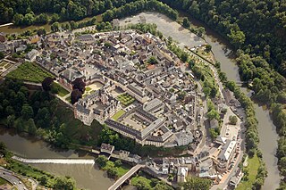
Limburg an der Lahn is the district seat of Limburg-Weilburg in Hesse, Germany.

<span class="mw-page-title-main">Weilburg</span> Town in Hesse, Germany

Weilburg is, with just under 14,000 inhabitants, the third biggest city in Limburg-Weilburg district in Hesse, Germany, after Limburg an der Lahn and Bad Camberg.

<span class="mw-page-title-main">Elz, Hesse</span> Municipality in Hesse, Germany

Elz is a municipality in Limburg-Weilburg district in western Hesse, Germany, on the boundary with Rhineland-Palatinate.

<span class="mw-page-title-main">Selters (Taunus)</span> Municipality in Hesse, Germany

Selters (Taunus) is a municipality with 8,000 inhabitants north of Bad Camberg in Limburg-Weilburg district in Hesse, Germany.

<span class="mw-page-title-main">Merenberg</span> Municipality in Hesse, Germany

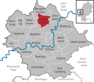
Merenberg is a municipality in Limburg-Weilburg district in Hesse, Germany.

<span class="mw-page-title-main">Bad Camberg</span> Town in Hesse, Germany

Bad Camberg is, with 15,000 inhabitants, the second largest town in Limburg-Weilburg district in Hesse, Germany, as well as the southernmost town in the Regierungsbezirk of Gießen. It is located in the eastern Taunus in the Goldener Grund some 30 km north of Wiesbaden, 18 km southeast of Limburg an der Lahn, and 44 km northwest of Frankfurt, as well as on the German Timber-Frame Road. Bad Camberg is the central community of the Goldener Grund with good infrastructure, and a lower centre partly with a middle centre's function.

<span class="mw-page-title-main">Hünfelden</span> Municipality in Hesse, Germany

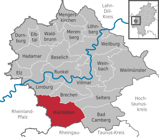
Hünfelden is a municipality in Limburg-Weilburg district in Hesse, Germany. Hünfelden lies on the Hühnerstraße, an historic part of Bundesstraße 417.

<span class="mw-page-title-main">Weinbach</span> Municipality in Hesse, Germany

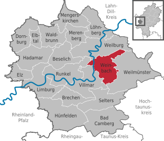
Weinbach is a municipality in Limburg-Weilburg district in Hesse, Germany.

<span class="mw-page-title-main">Runkel</span> Town in Hesse, Germany

Runkel is a town on the river Lahn in Limburg-Weilburg district in Hesse, Germany.

<span class="mw-page-title-main">Weilmünster</span> Municipality in Hesse, Germany

Weilmünster is a municipality in Limburg-Weilburg district in Hesse, Germany.

<span class="mw-page-title-main">Beselich</span> Municipality in Hesse, Germany

Beselich is a municipality in Limburg-Weilburg district in Hesse, Germany.

<span class="mw-page-title-main">Löhnberg</span> Municipality in Hesse, Germany

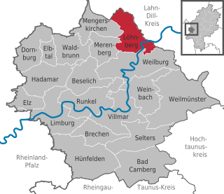
Löhnberg is a municipality north of Weilburg in Limburg-Weilburg district in Hesse, Germany.

<span class="mw-page-title-main">Mengerskirchen</span> Municipality in Hesse, Germany

Mengerskirchen is a municipality in Limburg-Weilburg district in Hesse, Germany.

<span class="mw-page-title-main">Villmar</span> Municipality in Hesse, Germany

Villmar is a market village and municipality in the Limburg-Weilburg district in Hesse, Germany. The community is the centre for quarrying and processing the so-called Lahn Marble.

<span class="mw-page-title-main">Waldems</span> Municipality in Hesse, Germany

Waldems is a municipality in the Rheingau-Taunus-Kreis in the Regierungsbezirk of Darmstadt in Hesse, Germany. The municipality's administrative seat is Waldems-Esch.

<span class="mw-page-title-main">Nentershausen, Rhineland-Palatinate</span> Municipality in Rhineland-Palatinate, Germany

Nentershausen is an Ortsgemeinde – a community belonging to a Verbandsgemeinde – in the Westerwaldkreis in Rhineland-Palatinate, Germany.

<span class="mw-page-title-main">Molsberg (Germany)</span> Municipality in Rhineland-Palatinate, Germany

Molsberg is an Ortsgemeinde – a community belonging to a Verbandsgemeinde – in the Westerwaldkreis in Rhineland-Palatinate, Germany.

The Countship of Isenburg-Limburg was a state of the Holy Roman Empire in the 13th and 14th centuries, based around the city of Limburg an der Lahn in modern Hesse, Germany.

<span class="mw-page-title-main">Dietkirchen</span> Borough of Limburg an der Lahn in Hesse, Germany

Dietkirchen an der Lahn is a borough (Ortsbezirk) of Limburg an der Lahn, seat of the district of Limburg-Weilburg in the state of Hesse, Germany. The formerly independent village was incorporated into Limburg in 1971. The town is dominated by the basilica St. Lubentius, which was the most important early-medieval church building in the region.

<span class="mw-page-title-main">Oberbrechen station</span> Railway station in Hesse, Germany

Oberbrechen station is a station on the Main-Lahn Railway, which runs from Frankfurt (Main) Hauptbahnhof to Limburg (Lahn), in the Brechen suburb of Niederbrechen in the German state of Hesse. With Niederbrechen station, it is one of two stations in Brechen. The station is in the network of the Rhein-Main-Verkehrsverbund (RMV) and is classified by Deutsche Bahn as a category 6 station and has two platform tracks.

References

  1. "Ergebnisse der letzten Direktwahl aller hessischen Landkreise und Gemeinden" (XLS) (in German). Hessisches Statistisches Landesamt. 5 September 2022.
  2. "Bevölkerung in Hessen am 31.12.2020 nach Gemeinden". Hessisches Statistisches Landesamt (in German). June 2021.

Further reading