
Jefferson County, Arkansas is a county located in the U.S. state of Arkansas in the area known as the Arkansas Delta, that extends west of the Mississippi River. As of the 2010 census, the population was 77,435. Its county seat and largest city is Pine Bluff. Jefferson County is Arkansas's 21st county, formed on November 2, 1829, from portions of Arkansas and Pulaski counties, and named for Thomas Jefferson, third President of the United States. Jefferson County is included in the Pine Bluff, Arkansas Metropolitan Statistical Area. The county is bisected by the Arkansas River, which was critical to its development and long the chief transportation byway.

Arkansas County is a county located in the U.S. state of Arkansas. As of the 2010 census, the population was 19,019. Located in the Arkansas Delta, the county has two county seats, De Witt and Stuttgart.

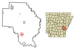
Almyra is a town in Arkansas County, Arkansas, United States. The population was 283 at the 2010 census.
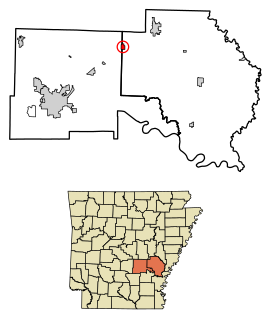
Gillett is a city in Arkansas County, Arkansas, United States. Its population was 691 at the 2010 census. Gillett is the home of the annual Gillett Coon Supper. The Arkansas Post National Memorial is located southeast of the town.
Humphrey is a city in Arkansas and Jefferson counties in the U.S. state of Arkansas. Its population was 557 at the 2010 census. It is included in the Pine Bluff Metropolitan Statistical Area.

U.S. Route 165 is a north–south United States highway spur of U.S. Highway 65. It currently runs for 412 miles (663 km) from U.S. Route 90 in Iowa, Louisiana north to U.S. Highway 70 in North Little Rock, Arkansas. The route passes through the states of Arkansas and Louisiana. It passes through the cities of Monroe and Alexandria in Louisiana. A segment of US 165 serves as a routing of the Great River Road within Arkansas.
DeWitt School District is a school district based in the town of DeWitt, Arkansas, United States. The DeWitt School District is geographically the state's largest school district with 872.29 square miles (2,259.2 km2) of land and 46.18 square miles (119.6 km2) of water, encompassing portions of Arkansas, Jefferson, and Desha counties.

DeWitt is a city in Clinton County, Iowa, United States. The population was 5,322 at the 2010 census, which represented a 5.2% increase over that of 2000, making it the fastest growing city in Clinton County.

Highway 1 is a north–south state highway in east Arkansas. The route of 159.88 miles (257.30 km) runs from US Route 278 (US 278) in McGehee north to Supplemental Route BB at the Missouri state line. One of the original 1926 state highways, Highway 1 has remained very close to its original routing. The highway contains an overlap of approximately 50 miles (80 km) with U.S. Route 49.
Crocketts Bluff is an unincorporated community in Arkansas County, Arkansas, United States. It is the location of Crocketts Bluff Hunting Lodge, which is located at the end of the dirt road north of the point at which AR 153 turns south, and is listed on the National Register of Historic Places. Crocketts Bluff sits at the highest point in Arkansas County.
Tichnor is an unincorporated community in Arkansas County, Arkansas, United States. It is the location of the Tichnor Rice Dryer and Storage Building, and is the nearest community to the Roland Site, both listed on the National Register of Historic Places.

Arkansas Highway 11 is a designation for three state highways in Arkansas. One segment of 36.23 miles (58.31 km) runs from US Route 63 (US 63) at Pansy to Huff Island Public Use Area near Grady. A second segment of 12.83 miles (20.65 km) begins just across the Arkansas River at the eastern terminus of Highway 88 at Reydell and runs north to US 65 west of De Witt. A third route of 37.53 miles (60.40 km) runs from Interstate 40 (I-40) and US 63 in Hazen north to Highway 367 in Searcy.

Bayou Meto is an unincorporated community in Arkansas County, Arkansas, United States. The community is located where Arkansas Highway 276S diverges from Arkansas Highway 276.
Lodge Corner is an unincorporated community in Arkansas County, Arkansas, United States. The community is located where Arkansas Highway 276 begins at U.S. Route 165.
One Horse Store is an unincorporated community in Arkansas County, Arkansas, United States. The community is located where Arkansas Highway 276 intersects Arkansas Highway 11.
Reydell is an unincorporated community in Jefferson County, Arkansas, United States. Reydell is located at the junction of Arkansas Highway 11 and Arkansas Highway 88, 16 miles (26 km) southwest of De Witt. Reydell has a post office with ZIP code 72133.
Ethel is an unincorporated community in Arkansas County, Arkansas, United States. Ethel is located on Arkansas Highway 17, 10 miles (16 km) east of DeWitt. Ethel has a post office with ZIP code 72048.
DeWitt High School is a comprehensive public high school located in De Witt, Arkansas, United States. The school provides secondary education for students in grades 9 through 12. DeWitt is one of two public high schools in Arkansas County, Arkansas and the sole high school administered by the DeWitt School District.
Searcy County School District No. 17 (SCSD), formerly Marshall School District #17 (MSD), is a public school district headquartered in Marshall, Arkansas. The school district encompasses 538.90 square miles (1,395.7 km2) of land in Searcy, Van Buren and Marion counties. Prior to the 2004 merger with the Leslie School District, the Marshall school district served portions of Searcy and Marion counties.
Stinking Bay is an unincorporated community in Arkansas County, Arkansas, United States.


