Interstate 278 (I-278) is an auxiliary Interstate Highway in New Jersey and New York in the United States. The road runs 35.62 miles (57.32 km) from U.S. Route 1/9 (US 1/9) in Linden, New Jersey, to the Bruckner Interchange in the New York City borough of the Bronx. The majority of I-278 is in New York City, where it serves as a partial beltway and passes through all five of the city's boroughs. I-278 follows several freeways, including the Union Freeway in Union County, New Jersey; the Staten Island Expressway (SIE) across Staten Island; the Gowanus Expressway in southern Brooklyn; the Brooklyn–Queens Expressway (BQE) across northern Brooklyn and Queens; a small part of the Grand Central Parkway in Queens; and a part of the Bruckner Expressway in the Bronx. I-278 also crosses multiple bridges, including the Goethals, Verrazzano-Narrows, Kosciuszko, and Triborough Bridges.
Port Coquitlam is a city in British Columbia, Canada. Located 27 km (17 mi) east of Vancouver, it is on the north bank of the confluence of the Fraser River and the Pitt River. Coquitlam borders it on the north, the Coquitlam River borders it on the west, and the city of Pitt Meadows lies across the Pitt River. Port Coquitlam is almost entirely bisected by Lougheed Highway. Port Coquitlam is often referred to as "PoCo." It is Canada's 88th-largest city by population. Port Coquitlam is not to be confused with the adjacent and larger Coquitlam.
Highway 1 is the main route of the Trans-Canada Highway through British Columbia. Its total accumulated distance through British Columbia is 1,039 km (646 mi), including the distance travelled on ferries. It is the westernmost portion of the "Highway 1" designation of the TCH through Western Canada, which extents to the Manitoba-Ontario boundary.

Highway 7B, known as the Mary Hill Bypass, is a 7.27 km (4.52 mi) long riverside east-west link between the cities of Coquitlam to the west and Port Coquitlam to the east. The Mary Hill Bypass gained its '7B' designation in 1996, when it was widened from two to four lanes. Highway 7B meets Highway 7 at both of its ends, and also links to Highway 1 within Coquitlam at the Cape Horn Interchange.

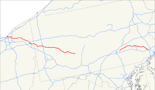
U.S. Route 378 is a spur of US 78 in the U.S. states of Georgia and South Carolina. The U.S. Highway runs 234.30 miles (377.07 km) from US 78, Georgia State Route 10, SR 17, and SR 47 in Washington, Georgia, east to US 501 Business in Conway, South Carolina. US 378 connects the Central Savannah River Area in both states with the Midlands and Pee Dee regions of South Carolina. The U.S. Highway's western portion, which connects Washington and Lincolnton in Georgia and McCormick, Saluda, and Lexington in South Carolina, is mainly a rural highway. US 378 is a major suburban and urban highway through Lexington and the South Carolina state capital, Columbia. The highway has a lengthy concurrency with US 76 between Columbia and Sumter and serves as a major route between the Midlands and the Myrtle Beach area, between which the highway has a business route through Lake City.

Interstate 275 (I-275), located in Florida, is a 60-mile-long (97 km) highway serving the Tampa Bay Area. Its southern terminus is at Interstate 75 near Palmetto, where I-275 heads west towards the Sunshine Skyway Bridge crossing over Tampa Bay. From that point, I-275 passes through St. Petersburg before crossing Tampa Bay again on the Howard Frankland Bridge, then continues through the city of Tampa, where it connects to an interchange with Interstate 4 in Downtown Tampa. After the interchange, I-275 passes north through the Tampa suburbs to its northern terminus at Interstate 75 in Wesley Chapel.

Dundas Street, is a major historic arterial road in Ontario, Canada. The road connects the city of Toronto with its western suburbs and several cities in southwestern Ontario. Three provincial highways—2, 5, and 99—followed long sections of its course, although these highway segments have since been downloaded to the municipalities they passed through. Originally intended as a military route to connect the shipping port of York to the envisioned future capital of London, Ontario, the street today connects Toronto landmarks such as Yonge-Dundas Square and the city's principal Chinatown to rural villages and the regional centres of Hamilton and London.

New York Avenue is diagonal avenue radiating northeast from the White House in Washington, D.C., to the border with Maryland. It is a major east–west route in the city's Northwest and Northeast quadrants and connects downtown with points east and north of the city via Cheverly, Maryland, the John Hanson Highway, the Baltimore-Washington Parkway, and eventually Interstate 95.
The Schuylkill Expressway, locally known as "the Schuylkill", is a two to eight lane freeway through southwestern Montgomery County and the city of Philadelphia, and the easternmost segment of Interstate 76 in the U.S. state of Pennsylvania. It extends from the Valley Forge exit of the Pennsylvania Turnpike in King of Prussia, paralleling its namesake Schuylkill River for most of the route, to the Walt Whitman Bridge in South Philadelphia. It serves as the primary corridor into Philadelphia from points west. Maintenance and planning are administered through PennDOT District 6. Constructed over a period of ten years from 1949 to 1959, a large portion of the expressway predates the 1956 introduction of Interstate Highway System; many of these portions were not built to contemporary standards. The rugged terrain, limited riverfront space covered by the route and narrow spans of bridges passing over the highway have largely stymied later attempts to upgrade or widen the highway. With the road being highly over capacity, it has become notorious for its chronic congestion. In recent years, it is the busiest road in Philadelphia, as well as in the entire commonwealth of Pennsylvania. An average 163,000 vehicles use the road daily in Philadelphia County, and an average of 109,000 use the highway in Montgomery County. Its narrow lane and left shoulder configuration, left lane entrances and exits, common construction activity and generally congested conditions have led to many accidents, critical injuries and fatalities, leading to the highway's humorous nickname of the "Surekill Expressway" or in further embellishment, the "Surekill Distressway" or the “Surekill Crawlway".

The Industrial Canal is a 5.5 mile (9 km) waterway in New Orleans, Louisiana, United States. The waterway's proper name, as used by the U.S. Army Corps of Engineers and on NOAA nautical charts, is Inner Harbor Navigation Canal (IHNC). The more common "Industrial Canal" name is used locally, both by commercial mariners and by landside residents.
U.S. Route 422 (US 422) is a 271-mile (436 km) long spur route of US 22 split into two segments in the U.S. states of Ohio and Pennsylvania. The western spur of US 422 begins in downtown Cleveland and ends at Ebensburg, Pennsylvania. The eastern spur, located entirely within Pennsylvania, begins in Hershey and ends at King of Prussia, PA, near Philadelphia. U.S. Route 422 Business is the offshoot road into each of 4 towns along the way.
The 11th Street Bridges are a complex of three bridges across the Anacostia River in Washington, D.C., United States. The bridges convey Interstate 695 across the Anacostia to its southern terminus at Interstate 295 and DC 295. The bridges also connect the neighborhood of Anacostia with the rest of the city of Washington.

Anthony Henday Drive (Highway 216) is a 77-kilometre (48 mi) freeway that encircles Edmonton, Alberta, Canada. It is a heavily travelled commuter and truck bypass route with the southwest quadrant serving as a portion of the CANAMEX Corridor that links Canada to the United States and Mexico. Henday is one of the busiest highways in Western Canada, carrying over 105,000 vehicles per day near West Edmonton Mall in 2017. Rush hour congestion is common on the four-lane section in southwest Edmonton where traffic levels have doubled Alberta Transportation estimates due to rapid suburban development; in June 2018 Alberta committed to widening this section to six lanes by 2022.

The Third Avenue Bridge carries southbound road traffic on Third Avenue over the Harlem River, connecting the boroughs of Manhattan and the Bronx in New York City. It once carried southbound New York State Route 1A. The Third Avenue Bridge carries traffic south from the intersections of either Third Avenue and East 135th Street, or Bruckner Boulevard and Lincoln Avenue, in the Bronx. On the Manhattan side, the bridge funnels traffic into three locations: East 128th Street; the intersection of East 129th Street and Lexington Avenue; or the southbound Harlem River Drive in Manhattan.
Interstate 95 (I-95) is an Interstate highway running from Miami, Florida, north to Houlton, Maine. In the U.S. state of Pennsylvania, it runs 44.25 miles (71.21 km) from the Delaware state line near Marcus Hook to the Delaware River–Turnpike Toll Bridge at the New Jersey state line. From the Delaware state line to exit 40, the route is known by many as the Delaware Expressway, but is officially named the Vietnam Veterans Memorial Highway. North(east) of exit 40, I-95 runs along the easternmost portion of the Pennsylvania Turnpike. I-95 parallels its namesake Delaware River for its entire route through the city of Philadelphia and its suburbs. It is a major route through the city and the metropolitan Delaware Valley, providing access to locally important landmarks such as Philadelphia International Airport, the South Philadelphia Sports Complex, Talen Energy Stadium, Penn's Landing, and Philadelphia Mills. Of the 15 states that Interstate 95 runs through, Pennsylvania is the only one that does not border the Atlantic Ocean.

Pennsylvania Route 291 is an east–west route in Pennsylvania that runs from U.S. Route 13 in Trainer, Delaware County east to Interstate 76 (I-76) in South Philadelphia near the Walt Whitman Bridge and the South Philadelphia Sports Complex. Except for a short 1-mile (1.6 km) section between US 13 and the Chester/Trainer line, PA 291 is mostly a four-lane highway. It runs parallel to the Delaware River. The route passes through industrial areas near the river in Delaware County, serving Chester, Eddystone, Essington, and Lester. PA 291 enters Philadelphia near the Philadelphia International Airport, at which point it has an interchange with I-95. The route crosses the Schuylkill River on the George C. Platt Memorial Bridge and continues along Penrose Avenue to I-76.

The Clyde Arc, is a road bridge spanning the River Clyde in Glasgow, in west central Scotland, connecting Finnieston, near the Clyde Auditorium and SEC with Pacific Quay and Glasgow Science Centre in Govan. A prominent feature of the bridge is its innovative curved design and the way that it crosses the river at an angle. The Arc is the first city centre traffic crossing over the river built since the Kingston Bridge was opened to traffic in 1969.

U.S. Route 1 (US 1) is the easternmost and longest of the major north–south routes of the older 1920s era United States Numbered Highway System, running from Key West, Florida to Fort Kent, Maine. In the U.S. state of Maryland, an 80.86-mile (130.13 km) segment of the route runs through central Maryland between Mount Rainier and Rising Sun.
Olde Richmond is a neighborhood in the River Wards section of Philadelphia, Pennsylvania. It is notable for its historically large Polish immigrant, Polish American community, and Irish American community. The U.S. zip code for Olde Richmond is 19125 and its Post Office is located at 1602 Frankford Avenue.
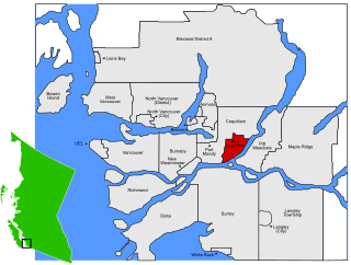
The Cape Horn Interchange, named after nearby Cape Horn Avenue, is a major interchange on British Columbia Highway 1, where it connects to Lougheed Highway, a heavily signalized thoroughfare in Coquitlam, Port Coquitlam, and Burnaby, and the Mary Hill Bypass, bypassing the Coquitlam and Port Coquitlam sections of Lougheed Highway and forming the quickest route to Pitt Meadows and Maple Ridge. It also includes several exits to United Boulevard, a light-industrial and commercial road in southern Coquitlam.


