
Richmond is a city in the coastal Lower Mainland region of British Columbia, Canada. Mainly a suburban city, it occupies almost the entirety of Lulu Island, between the two estuarine distributaries of the Fraser River. Encompassing the adjacent Sea Island and several other smaller islands and uninhabited islets to its north and south, the suburb neighbours Vancouver and Burnaby on the Burrard Peninsula to the north, New Westminster and Annacis Island to the east, Delta to the south, and the Strait of Georgia to the west.

Vancouver International Airport is an international airport located on Sea Island in Richmond, British Columbia, serving the city of Vancouver and the Lower Mainland region. It is located 12 km (7.5 mi) from Downtown Vancouver. YVR is the second busiest airport in Canada by passenger traffic, behind Toronto Pearson International Airport in Ontario. As a trans-Pacific hub, the airport has more direct flights to China than any other airport in North America or Europe. It is a hub for Air Canada and WestJet. Vancouver International Airport is one of eight Canadian airports that have US Border Pre-clearance facilities. It is also one of the few major international airports to have a terminal for scheduled float planes.

A bridge to nowhere is a bridge where one or both ends are broken, incomplete, or unconnected to any roads. If it is an overpass or an interchange, the term overpass to nowhere or interchange to nowhere may be used respectively.

The Canada Line is a rapid transit line in Greater Vancouver, British Columbia, Canada, that is part of the SkyTrain system. The line is owned by TransLink and InTransitBC and is operated by ProTrans BC. Coloured turquoise on route maps, it operates as an airport rail link between Vancouver, Richmond, and the Vancouver International Airport (YVR). The line comprises 16 stations and 19.2 kilometres (11.9 mi) of track; the main line runs from Vancouver to Richmond while a 4-kilometre (2.5 mi) spur line from Bridgeport station connects to the airport. It opened on August 17, 2009, ahead of the 2010 Winter Olympics.
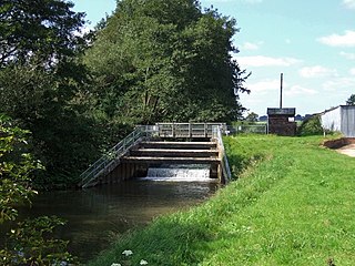
The River Lymn is a river in Lincolnshire, England. It rises in the Wolds on the eastern slope of Castcliffe Hill in Fulletby parish. It flows south-eastwards to the Lincolnshire Marsh, where it becomes known as the Steeping River on the boundary of Great Steeping parish. The main channel is supplemented by the Wainfleet Relief Channel as it passes Wainfleet All Saints, and the relief channel is joined by the old course of the Lymn. Once the two channels rejoin, there are three flood defence structures to protect the region from flooding by the North Sea.

—

The Knight Street Bridge is a crossing over the north arm of the Fraser River, the Canadian National Railway (CNR) line, and several roads, in Metro Vancouver.

The Oak Street Bridge is a crossing over the north arm of the Fraser River, the Canada Line, and several roads, in Metro Vancouver.

Transportation in the Commonwealth of Virginia is by land, sea and air. Virginia's extensive network of highways and railroads were developed and built over a period almost 400 years, beginning almost immediately after the founding of Jamestown in 1607, and often incorporating old established trails of the Native Americans.

The M5 is an expressway in the City of Cape Town Metropolitan Municipality, South Africa. It connects Milnerton on the Western Seaboard in the north to Muizenberg in the south, and crosses both the N1 and the N2. For part of its length, from the N1 interchange to Plumstead, it is a limited-access freeway (motorway). From Mowbray to Muizenberg it is parallel to the M4 Main Road.
The Moray Bridge, also known as the Moray Channel Bridge, and formerly the Middle Arm Bridge, is a crossing over the middle arm of the Fraser River in Metro Vancouver. Richard Moody, who would name geographical features, such as this channel, after acquaintances, honoured Jonathan Moray (1824–84), a sergeant in the Corps of Royal Engineers, and later the New Westminster police chief.

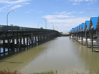
The Sea Island Connector, is a crossing over the middle arm of the Fraser River in Metro Vancouver.

The Dinsmore Bridge is a crossing over the middle arm of the Fraser River, and a former section of River Rd., in Metro Vancouver.

Sea Island is an island in the Fraser River estuary in the city of Richmond, British Columbia, Canada. It is located south of the city of Vancouver and northwest of Lulu Island.

The Federation Trail is a 23-kilometre-long (14 mi) shared use path for cyclists and pedestrians, which mainly follows the heritage-listed Main Outfall Sewer through the western suburbs of Melbourne, Victoria, Australia. There are three bridges spanning across major arterial roads, as well as button-activated traffic light crossings at most other major road-trail intersections.

The Marpole CP Rail Bridge is a partially dismantled crossing over the north arm of the Fraser River, and River Dr., in Metro Vancouver.

Whitiora Bridge is a prestressed concrete box girder bridge in Hamilton, New Zealand, spanning the Waikato River. It cost $2.35m, or $3.4m including the approach roads, and was opened at the start of a weekend of Centennial celebrations, on 11 February 1978, by representatives of Māori, Government and City, Dame Te Atairangikaahu, Venn Young and Ross Jansen.
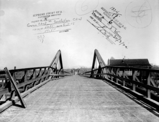
The Marpole Bridge (1889–1957), a.k.a. Eburne Bridge, North Arm Bridge, Sea Island Bridge, or Middle Arm Bridge, was consecutive crossings over the north and middle arms of the Fraser River in Metro Vancouver.
The Fraser St. Bridge (1894–1974), also known as the Fraser Ave. Bridge, North Arm Bridge, No. 5 Rd. Bridge, or Twigg Island Bridge, was a crossing over the north arm of the Fraser River in Metro Vancouver.

