Oak Street Bridge

Last updated

Oak Street Bridge
Oak Street Bridge.jpg
Coordinates 49°11′59″N123°07′32″W / 49.19972°N 123.12556°W / 49.19972; -123.12556
CarriesFour lanes of British Columbia Highway 99, and pedestrians/bicycles
Crosses North Arm Fraser River
Locale Vancouver-Richmond
Owner British Columbia Ministry of Transportation and Infrastructure
Characteristics
Design girder bridge
History
OpenedJune 29, 1957 [1] [2] [3]
Location
Oak Street Bridge

The Oak Street Bridge is a crossing over the north arm of the Fraser River, the Canada Line, and several roads, in Metro Vancouver.

Contents

History

Infrastructure

During the planning stage, it was known as the New Marpole Bridge, [4] and steel plate girders salvaged from the second Granville Street Bridge made barges for constructing the foundations of the Oak St. Bridge. [5]

Opened in June 1957, the same date as the Moray Bridge, these links replaced the Marpole Bridge (road). The new configuration created a more circuitous route between Vancouver and Vancouver International Airport (YVR), not restored until the Arthur Laing Bridge opened in 1975. [6] Initially, the highway ended at No. 4 Rd, [7] short of connecting with No. 5 Rd. and the Ladner Ferry. A primary objective was to create a fast route to the U.S. border, partially realized on the 1959 opening of the Deas Tunnel, and fully with the 1962 opening of Highway 99 to the border. A branch is connected to the new Tsawwassen ferry terminal. [8]

Vancouver regarded the bridge as a source of unwanted traffic. [9] Despite federal promises to share construction costs, the province ended up wholly financing the project. [10] Costing about $9m, the structure is 1,839.2 metres (6,034 ft) long. [11] The main spans comprise haunched (deeper at supports) steel girders, and the approaches are steel or concrete girders. The central heavy steel deck plate girders, continuous over three spans, measure 60.9 metres (200 ft), 91.4 metres (300 ft), and 60.9 metres (200 ft). [12] The freeway standard of Highway 99 ends where the bridge joins the Vancouver surface street grid. Average daily crossings were 85,000 cars in 2000. [13] Averaging 18,000 cars on opening, [11] summer daily averages were 70,000 in 1970, [14] 74,000 in 1975, [15] and 71,000 in 1980. [16]

The Ministry of Transportation and Infrastructure for BC owns and maintains [17] this high-level, four-lane bridge. Cyclists are legally required to ride on the sidewalks. [18]

Tolls

The premier announced that the 25-cent toll would remain for 12½ years [19] to cover construction costs for both the Oak St. and Moray bridges. [20] A week later, he revised this to two years, a promise not fulfilled. Initially, to avoid tolls, most traffic used the Fraser Street Bridge, causing massive congestion, leaving Oak St. Bridge underused. [19] Toll plazas existed on Sea Island Way and on the highway south off the bridge. [21] [22]

On opening, the Deas Tunnel toll was 50 cents, but a combined tunnel/bridge ticket was 60 cents. [23] [24]

However, weekly tickets offered huge savings. A book of 24 tickets usable at each crossing cost $1.25, amended to $1 for 20 tickets from June 1960. [25]

The premier announced that tolls would be lifted from all highways on April 1, 1964, [26] but were removed at 7:30 pm the previous evening. [27] George Massey, after whom the tunnel was renamed, and an outspoken opponent of the tolls, paid the final toll at the bridge that evening. [19] The toll booths were removed, and the roadway narrowed accordingly. [28]

Later, the Coquihalla Highway had staffed toll booths (1986–2008), and electronic tolling operated on the new Golden Ears (2009–2017), and Port Mann (2012–2017) bridges.

Maintenance, upgrades and incidents

During the morning rush hour of November 27, 1959, heavy fog and road ice caused pileups that damaged 150 cars. The largest involved 35 cars, the next 23 and the third 18. Seven people went to hospital. [29]

In 1964, a driver, who suffered stroke, plunged off the south end. Sustaining minor injuries from the accident, he died in hospital. [30]

The Oak St. Bridge/Highway 99 interchange with Bridgeport Rd./Sea Island Way was modified in 1969–70, [31] and 2001. [32] Despite extensive work on the bridge deck expansion joints in 1973–74, [33] they were rebuilt during 1976–78, and the deck repaved. [34] [35] In 1980–81, major pier protection system was installed. [16]

In 1995, owing to extensive deterioration of the bridge deck and precast sidewalk panels, two lanes were closed alternately [36] for resurfacing the deck with a high performance concrete, followed by a waterproof membrane, and asphalt. Recent traffic accidents that highlighted important safety deficiencies prompted the installation of no-posts at the median and curbs. The deck joints were again replaced, and deteriorated concrete on the bridge underside removed and patched. [37]

The cast-in-place concrete girders of the southern approach were vulnerable to collapse from movements during soil liquefaction. To strengthen the under-reinforced girders, glass fibre reinforced polymer wraps, the most flexible of possible composites, were chosen. Installed over four separate contracts, the seismic retrofit was completed in 2002. [38]

Neighbourhood redevelopment

Northeastward, CP Rail Bridge in foreground,
Oak St. Bridge in background Oak Street Bridge and Fraser River, Vancouver - panoramio.jpg
Northeastward, CP Rail Bridge in foreground,
Oak St. Bridge in background

After the bridge opened, more than 50 stores at Hudson and Marine Drive closed from lost business. Low-rise stucco apartments replaced older houses. Once the Arthur Laing Bridge opened, Granville Street developed as the commercial centre. [39]

At the south end of the Oak St. Bridge, construction started in 1960 on the first hotel at the highway interchange. Opening in 1962, the 62-room motor inn, initially called Delport Inn, then Airport Inn, was the birth of the Delta Hotels chain. [40] [41] Construction beginning in 1971, the 14-storey tower that opened the next year was the tallest building in Richmond. The project added 144 new suites, and included renovating and expanding the existing amenities. The property is now branded the Sandman Signature Hotel. [42]

Other hotels built in the immediate vicinity, and their current branding, are the Abercorn Inn (1981), [43] Travelodge Hotel (1984), [44] Accent Inn (1988), [45] and Sandman Hotel Airport (1999). [46]

On cleared land hugging the east side of the southern approach, two midrise office buildings and two hotels are under construction. [47] The Courtyard by Marriott and Residence Inn by Marriott brand hotels will provide 201 rooms. [48]

See also


Footnotes

  1. "Ribbon Cutters Open Oak Street Gateway". The Province. July 2, 1957. ProQuest   2369097745.
  2. "New Bridge Opened". Victoria Daily Times. July 2, 1957. ProQuest   2257741523.
  3. Ross, Leslie (1979). Richmond: Child of the Fraser (PDF). Richmond: Richmond '79 Centennial Society and the City of Richmond. p. 167. ISBN   0-9690031-0-2 . Retrieved October 1, 2022.
  4. "The Daily Colonist, 13 Jan 1954". www.archive.org. 1954.
  5. "Image: Oak St, Bridge piers". www.archives.richmond.ca.
  6. Dawe 1996, p. 47.
  7. "Image: Transit route map, 1957". www.vancouver.ca. Evergreen Press for BCER.
  8. Dawe 1996, p. 48.
  9. "The Daily Colonist, 6 Mar 1955". www.archive.org. 1955.
  10. Dawe 1996, p. 49.
  11. 1 2 "The Daily Colonist, 20 Jul 1971". www.archive.org. 1971.
  12. "Structure of the Oak St. Bridge". www.structurae.net.
  13. "Frontier to Freeway" (PDF). www2.gov.bc.ca. p. 29.
  14. "Highways Annual Report 1970–71". www.open.library.ubc.ca. p. B71.
  15. "Highways and Public Works Annual Report 1975–76". www.open.library.ubc.ca. p. B58.
  16. 1 2 "Transportation and Highways Annual Report 1980–81". www.open.library.ubc.ca. pp. 270 & 419.
  17. "Transportation Agencies". www.richmond.ca.
  18. "Cycling: Bridge Crossings". www.richmond.ca.
  19. 1 2 3 Dawe 1996, p. 50.
  20. "The Daily Colonist, 22 Jul 1955". www.archive.org. 1955.
  21. "Vancouver street map, 1962". www.vancouver.ca.
  22. "Image: Southeastward showing toll plaza, Delport Inn, and Cambie Rd. underpass, c.1963". www.reddit.com. October 17, 2019.
  23. "The Daily Colonist, 21 May 1959". www.archive.org. 1959.
  24. "The Daily Colonist, 26 May 1960". www.archive.org. 1960.
  25. "The Daily Colonist, 29 Jun 1960". www.archive.org. 1960.
  26. "The Daily Colonist, 22 Aug 1963". www.archive.org. 1963.
  27. "The Daily Colonist, 1 Apr 1964". www.archive.org. 1964.
  28. "Highways Annual Report 1964–65". www.open.library.ubc.ca. p. C153.
  29. "The Daily Colonist, 28 Nov 1959". www.archive.org. 1959.
  30. "The Daily Colonist, 2 Jun 1964". www.archive.org. 1964.
  31. "Highways Annual Report 1969–70". www.open.library.ubc.ca. pp. C102 & C189.
  32. "Airport Connector bridge opening". www.canadianshipper.com.
  33. "Highways Annual Report 1973–74". www.open.library.ubc.ca. p. B115.
  34. "Highways and Public Works Annual Report 1976–77". www.open.library.ubc.ca. p. B98.
  35. "Highways and Public Works Annual Report 1977–78". www.open.library.ubc.ca. p. I27.
  36. Dawe 1996, p. 52.
  37. Hamersley, B.; Jennings, D. (1996). "Oak St. Bridge deck rehabilitation". Cost Effectiveness Through Innovation: Proceedings of the 1996 TA Annual Conference, Charlottetown, Prince Edward Island, October 6 1997.[ verification needed ]
  38. Ding, Yuming; Hamersley, Bruce (2002). Seismic Upgrade of Oak Street Bridge with GFRP (PDF). 13th World Conference on Earthquake Engineering. Art. 3279. S2CID   166224239.
  39. "Marpole history". www.marpolehistorical.ca.
  40. "The Daily Colonist, 8 Mar 1968". www.archive.org. 1968.
  41. "Kelowna Daily Courier, 28 Jan 2015". www.kelownadailycourier.ca. January 28, 2015.
  42. "Reach for the Sky – The Dawn of the High-Rise in Richmond, 28 Nov 2019". www.richmondarchives.ca.
  43. "Abercorn Inn profile". www.travelweekly.com.
  44. "Travelodge Hotel profile". www.travelweekly.com.
  45. "Accent Inn profile". www.travelweekly.com.
  46. "Sandman Hotel Airport profile". www.travelweekly.com.
  47. "Two Marriot hotels coming to Richmond, 25 Apr 2019". www.westerninvestor.com. April 25, 2019.
  48. "Daily Hive, 6 Dec 2019". www.dailyhive.com.


Related Research Articles

<span class="mw-page-title-main">Canadian Pacific Hotels</span>

Canadian Pacific Hotels (CPH) was a division of the Canadian Pacific Railway (CPR) that primarily operated hotels across Canada, since passenger revenue made a significant contribution to early railway profitability. CPR restructured the division as a subsidiary in 1963. In 1988, CPR purchased the Canadian National Hotels chain, making Canadian Pacific Hotels and Resorts the nation's largest hotel owner. In 1998, all CPH properties were branded as either Fairmont or Delta.

<span class="mw-page-title-main">Arthur Laing</span> Canadian politician

Arthur Laing,, a Canadian politician, was actively involved with the BC Liberals, but his primary achievements were federally as a Liberal member of parliament. He served in the cabinets of prime ministers Lester B. Pearson and Pierre Trudeau.

Spuzzum is an unincorporated community in the lower Fraser Canyon area of southwestern British Columbia, Canada. The place is on the west shore of the Fraser River and north shore of Spuzzum Creek. The locality, on BC Highway 1, is by road about 40 kilometres (25 mi) north of Hope and 69 kilometres (43 mi) south of Lytton.

<span class="mw-page-title-main">Delta Hotels</span>

Delta Hotels by Marriott is a four-star brand of hotels and resorts located primarily in North America.

<span class="mw-page-title-main">Sicamous</span> District municipality in British Columbia, Canada

Sicamous is a district municipality in the Shuswap Country region of south central British Columbia. The place is adjacent to the narrows, which is the confluence of Mara Lake into Shuswap Lake. At the BC Highway 97A intersection on BC Highway 1, the locality is by road about 73 kilometres (45 mi) west of Revelstoke, 140 kilometres (87 mi) east of Kamloops, and 75 kilometres (47 mi) north of Vernon.

<span class="mw-page-title-main">Arthur Laing Bridge</span> Bridge in Richmond, Vancouver

The Arthur Laing Bridge is a crossing over the north arm of the Fraser River, and several minor roads, in Metro Vancouver.

<span class="mw-page-title-main">Knight Street Bridge</span> Bridge in Richmond, Vancouver

The Knight Street Bridge is a crossing over the north arm of the Fraser River, the Canadian National Railway (CNR) line, and several roads, in Metro Vancouver.

Union Bay is an unincorporated community located south of Hart Creek on the east coast of central Vancouver Island, British Columbia. This Comox Valley community on BC Highway 19A is by road about 93 kilometres (58 mi) north of Nanaimo, and 14 kilometres (9 mi) south of Courtenay.

<span class="mw-page-title-main">Alexandra Bridge Provincial Park</span> Provincial park in British Columbia, Canada

Alexandra Bridge Park lies within the lower Fraser Canyon of British Columbia, Canada. This provincial park is adjacent to the historic suspension bridge from 1926, which spans the Fraser River and was built using the eastern abutment of the bridge from 1863. The locality, on BC Highway 1, is by road about 44 kilometres (27 mi) north of Hope and 65 kilometres (40 mi) south of Lytton.

<span class="mw-page-title-main">Moray Bridge</span> Bridge in Richmond

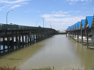
The Moray Bridge, also known as the Moray Channel Bridge, and formerly the Middle Arm Bridge, is a crossing over the middle arm of the Fraser River in Metro Vancouver. Richard Moody, who would name geographical features, such as this channel, after acquaintances, honoured Jonathan Moray (1824–84), a sergeant in the Corps of Royal Engineers, and later the New Westminster police chief.

<span class="mw-page-title-main">Dinsmore Bridge</span> Bridge in Richmond

The Dinsmore Bridge is a crossing over the middle arm of the Fraser River, and a former section of River Rd., in Metro Vancouver.

<span class="mw-page-title-main">Marpole Bridge</span> Bridge in Marpole–Richmond

The Marpole CP Rail Bridge is a partially dismantled crossing over the north arm of the Fraser River, and River Dr., in Metro Vancouver.

<span class="mw-page-title-main">Mission Bridge</span> Bridge on Highway 11 in southwestern British Columbia

The Mission Bridge is a steel and concrete girder bridge across the Fraser River in the Fraser Valley region of southwestern British Columbia, Canada. Linking the City Of Mission and the City of Abbotsford, the four-lane structure carries BC Highway 11.

Donald is an unincorporated community in the East Kootenay region of southeastern British Columbia. This almost ghost town is on the northeast shore of the Columbia River immediately southeast of the mouth of Marl Creek. The locality, on BC Highway 1, is by road about 28 kilometres (17 mi) northwest of Golden and 122 kilometres (76 mi) northeast of Revelstoke.

The Agassiz–Rosedale Bridge is a cantilever truss bridge across the Fraser River in the Fraser Valley region of southwestern British Columbia. Linking Agassiz with the south shore, the two-lane bridge carrying BC Highway 9 is by road about 36 kilometres (22 mi) west of Hope, 119 kilometres (74 mi) east of Vancouver, and 51 kilometres (32 mi) east of Abbotsford.

The Alexandra Bridge is a steel arch bridge across the Fraser River in the lower Fraser Canyon area of southwestern British Columbia, Canada. The two-lane crossing, carrying BC Highway 1, is by road about 44 kilometres (27 mi) north of Hope and 66 kilometres (41 mi) south of Lytton.

A series of ferries and bridges have crossed the Fraser River in the vicinity of Lillooet in the Squamish-Lillooet region of southwestern British Columbia. From the 1850s, these crossings have connected both north–south and local traffic.

<span class="mw-page-title-main">Ladner Ferry</span>

The Ladner Ferry was a crossing of the south arm of the Fraser River in Metro Vancouver, linking Ladner with Richmond. It operated from 1913 until 1959, when it was replaced by the George Massey Tunnel.

The Marpole Bridge (1889–1957), a.k.a. Eburne Bridge, North Arm Bridge, Sea Island Bridge, or Middle Arm Bridge, was consecutive crossings over the north and middle arms of the Fraser River in Metro Vancouver.

<span class="mw-page-title-main">Fraser Street Bridge (1894)</span> Bridge in Sunset-Richmond

The Fraser St. Bridge (1894–1974), also known as the Fraser Ave. Bridge, North Arm Bridge, No. 5 Rd. Bridge, or Twigg Island Bridge, was a crossing over the north arm of the Fraser River in Metro Vancouver.

References