Metrotown, Burnaby

Last updated
Metrotown
Metrotown 201807.jpg
Metrotown skyline as seen from Richmond, British Columbia
15 Metro Vancouver Regional District British Columbia.svg
Red pog.svg
Metrotown
Location of Metrotown within Metro Vancouver
Coordinates: 49°13′32″N123°00′12″W / 49.2255°N 123.0032°W / 49.2255; -123.0032
CountryFlag of Canada (Pantone).svg  Canada
ProvinceFlag of British Columbia.svg  British Columbia
Region Lower Mainland
Regional District Metro Vancouver
City Burnaby
QuadrantSouthwest
Government
   Mayor Mike Hurley
   MP (Fed.) Jagmeet Singh (NDP)
   MLA (Prov.) Anne Kang (NDP)
Area
[1]
  Land2.97 km2 (1.15 sq mi)
Population
 (2011) [2]
  Total24,889
Time zone UTC−8 (PST)
  Summer (DST) UTC−7 (PDT)
Area codes 604, 778, 236, 672

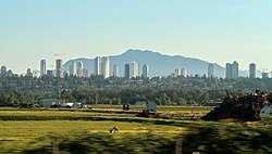
Metrotown is a town centre serving the southwest quadrant of Burnaby, British Columbia, Canada. It is one of the city's four officially designated town centres, [3] as well as one of Metro Vancouver's regional town centres. [4] It is the central business district of the City of Burnaby. [5]

Contents

As officially defined by the City of Burnaby, the town centre is bounded on the west by Boundary Road (taking in Central Park), on the south by Imperial Street, on the east by Royal Oak Avenue, and on the north by a series of local streets (Thurston, Bond, Grange and Dover streets), [6] giving an area of 2.97 km2 (730 acres). [1] [7] Kingsway forms the central commercial spine for the neighbourhood, and is paralleled to the south by the SkyTrain tracks running alongside Central Boulevard.

The area is served by Patterson and Metrotown SkyTrain stations, while Royal Oak station sits just beyond the southeastern limits of the district. The area is characterised by its many high rise commercial and residential buildings.

Name origin

Urban researcher and economist R. W. Archer credited the Baltimore Regional Planning Council (BRPC) for coining the term "metrotown" in 1962. [8] The BRPC envisioned metrotowns as "cohesive urban developments... deployed radially and in a series of rings around the City of Baltimore", each accommodating 100,000 to 200,000 people and at greater densities than what was then common in suburban areas. [9] [10]

Archer adapted the term in his two-part article From New Towns to Metrotowns and Regional Cities, which appeared in the July 1969 issue of The American Journal of Economics and Sociology , [11] to refer to "a unit for planned metropolitan development" consisting of a wide variety of land uses and offering "a large measure of local employment and city-type services", but still "significantly interdependent with the rest of the metropolis". [12] He further suggested that building a connected series of metrotowns was the most cost-effective manner for establishing new urban settlements, [11] and saw developments around Stockholm like Vällingby and Högdalen as examples of this type of built form. [13]

The term was subsequently adopted by the municipality of Burnaby in the 1970s, initially as a common noun to refer to a type of urban development; it eventually became a proper noun referring exclusively to the area around the intersection of Kingsway and Sussex Avenue.

History

SkyTrain tracks crossing over Kingsway in the western part of Metrotown, following the former Central Park Interurban's right of way Kingsway.JPG
SkyTrain tracks crossing over Kingsway in the western part of Metrotown, following the former Central Park Interurban's right of way

Settlement and industry

On the recommendation of Colonel Richard Moody, the Royal Engineers constructed a trail linking colonial capital New Westminster and False Creek to facilitate troop movement between the two points. [14] [15] The trail (which later became Kingsway) opened in 1860, and cut diagonally across Burrard Peninsula; [14] land was set aside as a military reserve at a plateau along the road in the area of modern-day Metrotown. [14] [15] The road was improved following Burnaby's municipal incorporation in 1892, and the parallel Central Park interurban line connecting Vancouver and New Westminster opened the previous year, making the area increasingly favourable for settlement. [14] Consequently, the provincial government established a series of holding lots out of the military reserve in the 1890s to accommodate working class residents. [14] [15] The lots were drawn at right angles to the interurban line, which ran from the northwest to the southeast, accounting for Metrotown's street orientation. [15]

During the Great Depression, Burnaby reeve William Pritchard instituted a series of make-work programs to put the unemployed to work, using municipal funds and loans. [15] This put a strain on Burnaby's finances, and in 1932 the province stepped in by suspending the functions of Burnaby's government and appointing a commissioner to run municipal affairs. [15] [16] Under the province's control, Burnaby struck a deal with the Ford Motor Company to build an assembly plant near Kingsway and McKay Avenue. [17] The plant opened in 1938, and was used to produce military vehicles during World War II; [17] it became an Electrolier facility at some point after the war. [18] Wholesale grocer Kelly-Douglas Company built a manufacturing plant and warehouse to the east of the Ford/Electrolier plant in 1946, and Simpsons-Sears opened a catalogue sales and distribution facility to the east of the Kelly-Douglas plant in 1954. [17]

Passenger service on the stretch of the Central Park interurban line through Burnaby and New Westminster ceased operations on October 23, 1953. [19]

Planning for a "metro town"

Building upon a 1964 report by the Lower Mainland Regional Planning Board (forerunner to the Greater Vancouver Regional District, GVRD), Burnaby's planning department prepared a report titled Apartment Study, which was approved by the municipal council in 1966. [20] In this document, Burnaby's planners proposed a hierarchical structure for co-locating housing, commercial activity and other amenities, with a "town centre" level as the highest tier. [21] The town centres were to serve as "a major focus of population and community activity", include "a complete cross section of commercial facilities" and "a full range of cultural and recreational activity", and provide residential accommodation "with easy access to well developed industrial areas and places of employment". [21] [22] The planners further identified three sites around the municipality as candidates to be developed into town centres: Brentwood, Lougheed and the area around the Simpsons-Sears facility at Kingsway and Sussex Avenue. [21]

Burnaby's planning department further conducted a survey of the local land-use structure, and published a hardcover book titled Urban Structure in 1971. Echoing Archer's metrotown concept, the book recommended establishing an "intermittent grid of metro towns" as the best alternative out of the various urban built forms. [23] [24] However, by 1974, the planners decided instead to create only one metro town, for fear that having multiple such developments (as recommended by Urban Structure) would divide the municipality's focus and drain its resources. [25] Brentwood, Lougheed and the Simpsons-Sears site were evaluated as candidates for the site of the sole metro town; with the former two locations already gravitating towards a car-centric pattern of development, the planners decided that the Simpsons-Sears site had the most potential to match their original vision for a metro town. [25] The report thus recommended that "the Kingsway/Sussex town centre be designated as a Metrotown development area"; the recommendation was approved by the municipal council in July 1974. [26]

Concurrent with planning at the municipal level, the GVRD also worked on addressing growth patterns at the regional level, and in 1975 released The Livable Region 1976/1986, which proposed establishing "regional town centres" (RTCs) in several locations around Greater Vancouver. Such centres were envisioned as nodes of employment, entertainment and cultural amenities serving the local population, in order to reduce travel into the city of Vancouver. [27] Burnaby's central location within the metropolitan area was seen as an advantage to siting an RTC in the municipality, [28] and with the planning process for the Metrotown development at Kingsway/Sussex already under way, the GVRD expected that designating Metrotown as an RTC would provide for the easiest implementation of the concept and set an example for future RTCs to be established in Surrey and Coquitlam. [29] [30] The site's location along the disused Central Park interurban was also considered favourable, as the GVRD was proposing to build a light rail transit system (which eventually became the SkyTrain) along that right of way. [31] The proposal thus recommended for an RTC to be "started immediately in the Central Park area of Burnaby" (as well as in downtown New Westminster). [30]

Burnaby and the GVRD subsequently launched a joint study of the Metrotown RTC, [28] and the municipality's planning department followed up in 1977 with the release of Metrotown's development plan, which further articulated the development concept and strategy for the area. [26] [32]

Uncertainty emerges

Metropolis at Metrotown and Metrotowers, developed at the site of the former Kelly-Douglas facility Metropolis at Metrotown.jpg
Metropolis at Metrotown and Metrotowers, developed at the site of the former Kelly-Douglas facility

Recessions in the 1970s and early 1980s, along with an altered political landscape following the 1979 municipal election, cast uncertainties onto the Metrotown development, [32] [33] with mayor Dave Mercier suggesting in 1981 that the Metrotown plans be revisited. [34] Meanwhile, with "Metrotown" being perceived by local residents as a "sterile name" unindicative of its environs, a naming contest was held in 1982 to rename the Kingsway/Sussex area. [35] "Orchard Park" was the leading candidate until the contest was called off by mayor Bill Lewarne, citing the expense associated with updating the literature already printed which promoted the area as Metrotown. [35]

By that point, Daon Development Corporation had emerged as the main developer for the Kelly-Douglas site at Metrotown, with proposals to build a department store complex, offices and residential towers. [36] [37] However, the recessionary environment and the company's financial woes continued to stall development. [36] Further complicating matters was a proposal by Triple Five Group (developers of West Edmonton Mall and Mall of America) to build a large mall and amusement centre at the corner of Lougheed Highway and Boundary Road. [38] Fearing this proposal would deflect activity away from Metrotown, municipal council reaffirmed in 1984 that Metrotown would remain as Burnaby's commercial core, [38] and mayor Lewarne stated that council would not rezone the Lougheed/Boundary site for the Triple Five proposal. [39] With the provincial government refusing to intervene, [40] the Triple Five proposal was abandoned. Nonetheless, while that proposal was in play, the Metrotown development experienced delays in locating anchor tenants, further worsening Daon's finances. [39] Daon pulled out of the development in 1985 before ceasing operations the next year; the Kelly-Douglas site was subsequently acquired by Cambridge Shopping Centres (now Ivanhoe Cambridge). [41]

Development resumes

The Crystal Mall complex, opened between 1999 and 2000 The Crystal.JPG
The Crystal Mall complex, opened between 1999 and 2000

Development in Metrotown began to pick up in the mid-1980s, in tandem with the launch in late 1985 of the SkyTrain system (including Metrotown Station), which follows the alignment of the former interurban through the area. The form of development, however, came to be dominated by retail complexes, differing markedly from the original vision for Metrotown as a pedestrian-oriented mixed-use node. [42]

Cal Investments received financial backing from Manulife Financial to develop the Simpsons-Sears site, [43] with ground breaking in August 1985 and completion targeted for fall 1986; [44] Sears was to remain as an anchor tenant at the new Metrotown Centre, to be joined in that role by Woodward's. [44]

The Electrolier site became Station Square, opened in 1988 by Wesbild Enterprises. On opening day in 1988, part of anchor tenant Save-On-Foods' rooftop parking deck collapsed, injuring 21 people but causing no deaths. [45] The strip mall closed in 2012 to go through redevelopment. Also called Station Square, it has five condominium towers that were all completed in August 2022. [46]

Cambridge developed the Kelly-Douglas site into Eaton Centre (named after its anchor), which opened in 1989; [47] the mall was renamed Metropolis following the demise of the Eaton's chain in 1999.

The Crystal Mall complex opened at Kingsway and Willingdon Avenue between 1999 and 2000, [48] incorporating an Asian-themed shopping centre, residential and commercial highrises, and a Hilton hotel. Ivanhoe Cambridge purchased Metrotown Centre in 2002, [15] [49] which was merged with Metropolis into a single mall (Metropolis at Metrotown) in 2005, [50] creating the third largest enclosed shopping mall in Canada by total retail floor space. [4] [51]

Features and amenities

Burnaby Public Library's Bob Prittie Metrotown branch BByLibrary.JPG
Burnaby Public Library's Bob Prittie Metrotown branch

Central Park sits at the western edge of Metrotown, and includes amenities such as tennis courts, an outdoor swimming pool, a pitch-and-putt golf course, and Swangard Stadium at its northwestern corner. [52] Smaller parks in the area include Kinnee Park, Maywood Park and Old Orchard Park. The area is also served by the Bonsor Recreation Complex [53] and the Burnaby Public Library's Bob Prittie Metrotown branch. [54]

Marlborough Elementary School and Maywood Community School (K-7) both fall within Metrotown's borders, while Chaffey-Burke Elementary sits just to the north. The closest secondary schools serving Metrotown are Moscrop Secondary School at Willingdon Avenue and Moscrop Street, and Burnaby South Secondary School near Royal Oak Avenue and Rumble Street. All aforementioned schools are operated by the Burnaby School District.

The town centre is also home to Old Orchard Shopping Centre, a strip mall at the intersection of Kingsway and Willingdon Avenue which pre-dates the malls along the south side of Kingsway built since the 1980s.

Demographics

Population

Population history
YearPop.±%
2001 24,518    
2006 25,540+4.2%
2011 27,970+9.5%
2016 29,009+3.7%
Source: Statistics Canada [55]

As of 2006, Metrotown had a population of 25,540, increasing by 4% from 2001. [56] Between 1991 and 2001, the town centre's population increased by 43.9%. [57] Jobs in the town centre numbered around 22,900 in 2006, accounting for 20% of employment in Burnaby. [58]

According to the 2006 census, 53% of the residents in the census tract immediately south of the Metrotown SkyTrain station commuted to work by public transit, the highest of any census tracts in Metro Vancouver; [59] public transit mode share to work for the entire Metrotown area was around 42%. [60]

Ethnicity

Ethnic groups in Metrotown (2016) [61] [62] [63] [64] [65] [66]
Ethnic groupPopulation %
East Asian 13,760
European 7,720
Southeast Asian 2,695
South Asian 1,805
Middle Eastern 1,220
Latin American 615
Aboriginal 395
Black 390
Other625
Total population29,009

Language

Languages spoken in Metrotown (2016) [61] [62] [63] [64] [65] [66]
Language %
English 30.5%
Mandarin 25.3%
Cantonese 11%
Tagalog 4.6%
Korean 4.3%
Russian 2.7%
Persian 2.6%
Spanish 2.3%
Punjabi 2.1%
Hindi 1.8%
Serbian 1.7%
Arabic 1.6%
Portuguese 1.2%
Other9.2%
Total %100%

Related Research Articles

<span class="mw-page-title-main">Lower Mainland</span> Region in British Columbia, Canada

The Lower Mainland is a geographic and cultural region of the mainland coast of British Columbia that generally comprises the regional districts of Metro Vancouver and the Fraser Valley. Home to approximately 3.05 million people as of the 2021 Canadian census, the Lower Mainland contains sixteen of the province's 30 most populous municipalities and approximately 60% of the province's total population.

<span class="mw-page-title-main">Surrey, British Columbia</span> City in British Columbia, Canada

Surrey is a city in British Columbia, Canada. It is located south of the Fraser River on the Canada–United States border. It is a member municipality of the Metro Vancouver regional district and metropolitan area. Mainly a suburban city, Surrey is the province's second-largest by population after Vancouver and the third-largest by area after Abbotsford and Prince George. Seven neighbourhoods in Surrey are designated town centres: Cloverdale, Fleetwood, Guildford, Newton, South Surrey, and City Centre encompassed by Whalley.

<span class="mw-page-title-main">Burnaby</span> City in British Columbia, Canada

Burnaby is a city in the Lower Mainland region of British Columbia, Canada. Located in the centre of the Burrard Peninsula, it neighbours the City of Vancouver to the west, the District of North Vancouver across the confluence of the Burrard Inlet with its Indian Arm to the north, Port Moody and Coquitlam to the east, New Westminster and Surrey across the Fraser River to the southeast, and Richmond on the Lulu Island to the southwest.

<span class="mw-page-title-main">Metro Vancouver Regional District</span> Regional district in British Columbia, Canada

The Metro Vancouver Regional District (MVRD), or simply Metro Vancouver, is a Canadian political subdivision and corporate entity representing the metropolitan area of Greater Vancouver, designated by provincial legislation as one of the 28 regional districts in British Columbia. The organization was known as the Regional District of Fraser–Burrard for nearly one year upon incorporating in 1967, and as the Greater Vancouver Regional District (GVRD) from 1968 to 2017.

<span class="mw-page-title-main">West Vancouver</span> District municipality in British Columbia, Canada

West Vancouver is a district municipality in the province of British Columbia, Canada. A member municipality of the Metro Vancouver Regional District, West Vancouver is to the northwest of the city of Vancouver on the northern side of English Bay and the southeast shore of Howe Sound, and is adjoined by the District of North Vancouver to its east. Together with the District of North Vancouver and the City of North Vancouver, it is part of a local regional grouping referred to as the North Shore municipalities, or simply "the North Shore".

<span class="mw-page-title-main">Vancouver South (federal electoral district)</span> Federal electoral district in British Columbia, Canada

Vancouver South is a federal electoral district in British Columbia, Canada, that has been represented in the House of Commons of Canada from 1917 to 1997, and since 2004. It covers the southern portion of the city of Vancouver, British Columbia.

<span class="mw-page-title-main">North Vancouver (district municipality)</span> Municipality in British Columbia, Canada

The District of North Vancouver is a district municipality in British Columbia, Canada, and is part of Metro Vancouver. It surrounds the City of North Vancouver on three sides. It is largely characterized as a relatively quiet, affluent suburban hub home to many middle and upper-middle-class families. Homes in the District of North Vancouver generally range from mid-sized family bungalows to very large luxury houses. A number of dense multi-family and mixed-use developments have popped up across the district in recent years; however, the district remains a primarily suburban municipality. It is served by the Royal Canadian Mounted Police, British Columbia Ambulance Service, and the District of North Vancouver Fire Department.

<span class="mw-page-title-main">Greater Vancouver</span> Metropolitan area in British Columbia, Canada

Greater Vancouver, also known as Metro Vancouver, is the metropolitan area with its major urban centre being the city of Vancouver, British Columbia, Canada. The term "Greater Vancouver" describes an area that is roughly coterminous with the region governed by the Metro Vancouver Regional District (MVRD), though it predates the 1966 creation of the regional district. It is often used to include areas beyond the boundaries of the regional district but does not generally include wilderness and agricultural areas that are included within the MVRD.

<span class="mw-page-title-main">Metrotown station</span> Metro Vancouver SkyTrain station

Metrotown is an elevated station on the Expo Line of Metro Vancouver's SkyTrain rapid transit system, and is located along Central Boulevard, directly across from the Metropolis at Metrotown shopping centre, in Burnaby, British Columbia, Canada. As of 2022, it is the second-busiest station in the SkyTrain system.

<span class="mw-page-title-main">Vancouver Kingsway</span> Federal electoral district in British Columbia, Canada

Vancouver Kingsway is a federal electoral district in British Columbia, Canada, that has been represented in the House of Commons of Canada from 1953 to 1988 and since 1997. It is located in Vancouver.

<span class="mw-page-title-main">Port Moody—Coquitlam</span> Federal electoral district in British Columbia, Canada

Port Moody—Coquitlam is a federal electoral district in British Columbia, Canada, that was represented in the House of Commons of Canada from 1997 to 2004 and since 2015.

<span class="mw-page-title-main">Kingsway (Vancouver)</span> Major road in British Columbia

Kingsway is a major thoroughfare that crosses through the Canadian cities of Vancouver and Burnaby, British Columbia. The road runs diagonally from northwest to southeast, emerging from Vancouver's Main Street just south of East 7th Avenue and becoming 12th Street at the Burnaby–New Westminster border.

<span class="mw-page-title-main">Westwood Plateau</span> Neighbourhood of Coquitlam in Lower Mainland, British Columbia, Canada

Westwood Plateau is a neighbourhood in the northern region of Coquitlam, British Columbia.

The demographics of Metro Vancouver indicate a multicultural and multiracial region. Metro Vancouver is a metropolitan area, with its major urban centre being Vancouver, British Columbia, Canada. The Vancouver census metropolitan area, as defined by Statistics Canada, encompasses roughly the same territory as the Metro Vancouver Regional District, a regional district in British Columbia. The regional district includes 23 local authorities. Figures provided here are for the Vancouver census metropolitan area and not for the City of Vancouver.

<span class="mw-page-title-main">Crystal Mall (British Columbia)</span> Shopping mall

The Crystal Mall is an ethnic shopping mall oriented towards the local Chinese community in Burnaby, British Columbia, Canada. It is located at 4500 Kingsway at the intersection with Willingdon Avenue in Metrotown, directly adjoined to the Hilton Metrotown Vancouver Hotel. A 26 floor residential tower called Residence at the Crystal was also constructed that connects to the rest of the shopping complex.

<span class="mw-page-title-main">Maillardville</span> Neighbourhood of Coquitlam in Lower Mainland, British Columbia, Canada

Maillardville is a community on the south slope of the city of Coquitlam, British Columbia, Canada.

South Asian Canadians in Metro Vancouver are the third-largest pan-ethnic group in the region, comprising 369,295 persons or 14.2 percent of the total population as of 2021. Sizable communities exist within the city of Vancouver along with the adjoining city of Surrey, which houses one of the world's largest South Asian enclaves.

Alexander College is a private post-secondary institution in Burnaby, British Columbia, Canada. It was established in 2006 under the British Columbia Ministry of Advanced Education.

Edmonds is a neighbourhood in the southeast of Burnaby, British Columbia, Canada. It is considered one of four town centres by the city of Burnaby. The SkyTrain's Edmonds station serves the area.

References

Footnotes
  1. 1 2 Burnaby Planning Department 1977, p. 14.
  2. "Metrotown Highlights" (PDF). City of Burnaby. Archived from the original (PDF) on July 20, 2017. Retrieved September 9, 2017.
  3. "Town Centres". City of Burnaby. Archived from the original on 2021-02-17. Retrieved 2012-12-21.
  4. 1 2 "Metrotown City Centre". Metro Vancouver. Archived from the original on 2013-01-06. Retrieved 2012-12-21.
  5. "Metrotown Downtown Plan". City of Burnaby. Retrieved 30 September 2019.
  6. Perkins 1992, p. 159.
  7. "Metrotown General Land Use Map" (PDF). City of Burnaby. Archived from the original (PDF) on 2018-10-13. Retrieved 2012-12-21.
  8. Pereira 2011, p. 15.
  9. Baltimore Regional Planning Council; Maryland State Planning Department (1962). Metrotowns for the Baltimore Region: A pattern emerges (Report). pp. 2–3.
  10. O'Bryan, Deric; McAvoy, Russell L. (1966). Gunpowder Falls Maryland: Uses of a water resource today and tomorrow. U.S. Geological Survey. p. 64.
  11. 1 2 Pereira 2011, p. 14.
  12. R. W. Archer (1969). "From New Towns to Metrotowns and Regional Cities, I". The American Journal of Economics and Sociology . 28 (3): 257–269. doi:10.1111/j.1536-7150.1969.tb03223.x.
  13. R. W. Archer (1969). "From New Towns to Metrotowns and Regional Cities, II". The American Journal of Economics and Sociology . 28 (3): 385–398. doi:10.1111/j.1536-7150.1969.tb03104.x.
  14. 1 2 3 4 5 Beasley 1976, pp. 106–107.
  15. 1 2 3 4 5 6 7 Glavin, Terry (2006). "Lost Cities". Vancouver Review. Archived from the original on 2013-04-11. Retrieved 2012-12-21.
  16. "Young Burnaby: 1911-1943" (PDF). City of Burnaby. Archived from the original (PDF) on 2020-09-21. Retrieved 2012-12-21.
  17. 1 2 3 "Burna-Boom 1925 - 1954". Heritage Burnaby. Archived from the original on 2012-10-11. Retrieved 2012-12-21.
  18. Burnaby Planning Department 1977, p. 18.
  19. Ewert, Henry (January–February 2010). "British Columbia Electric Railway Company Limited" (PDF). Canadian Rail (534): 9. Archived from the original (PDF) on 2013-06-22. Retrieved 2013-01-01.
  20. Pereira 2011, p. 34.
  21. 1 2 3 Pereira 2011, p. 35.
  22. Parr, A.L.; Burnaby Planning Department (1966). Apartment Study (Report). pp. 2–3.
  23. Pereira 2011, p. 45.
  24. Beasley 1976, pp. 35–37.
  25. 1 2 Pereira, David. "The Town Centre Model: Part 3" . Retrieved 2012-12-25.
  26. 1 2 Burnaby Planning Department 1977, p. 7.
  27. Greater Vancouver Regional District 1975, p. 18.
  28. 1 2 Greater Vancouver Regional District 1975, p. 32.
  29. Perkins 1992, p. 48.
  30. 1 2 Greater Vancouver Regional District 1975, p. 20.
  31. Greater Vancouver Regional District 1975, p. 20–21, 24.
  32. 1 2 Pereira, David. "Metrotown" . Retrieved 2012-12-25.
  33. Pereira 2011, pp. 88–91.
  34. Mackey, Lloyd (1981-09-16). "Burnaview". Burnaby Today.
  35. 1 2 "Metrotown name stays". Burnaby Today. 1982-10-20.
  36. 1 2 "No early awakening for Metrotown". Burnaby Today. 1982-09-08.
  37. "Daon plans huge project". Burnaby Now. 1983-12-12.
  38. 1 2 "Backroom deal favors mall; Political involvement slammed". Burnaby Now. 1985-02-04.
  39. 1 2 "Kiss Metrotown Goodbye?". Burnaby Now. 1985-02-25.
  40. "Victoria 'out' of mall brawl". Burnaby Now. 1985-02-11.
  41. "Daon out of Metrotown". Burnaby Now. 1985-10-16.
  42. Pereira 2011, p. 91.
  43. "Metrotown makes it big". Burnaby Now. 1985-04-01.
  44. 1 2 "Bulldozers mark Metrotown's start". Burnaby Now. 1985-09-02.
  45. Feld, Jacob; Carper, Kenneth L. (1996). Construction Failure. John Wiley & Sons. pp. 193–194. ISBN   9780471574774.
  46. Chan, Kenneth (September 26, 2022). "That time Save-On-Foods Metrotown collapsed during its grand opening". Daily Hive. Burnaby, B.C. Retrieved April 10, 2023.
  47. Constantineau, Bruce (1987-02-25). "Developers take Burnaby to court". The Vancouver Sun .
  48. "About Us". The Crystal Mall. Archived from the original on 2013-01-03. Retrieved 2012-12-29.
  49. "Ivanhoe Canmbridge Purchases Metrotown Centre". Lexpert Magazine. Retrieved 2020-12-04.
  50. 2005 Report on Activities (PDF) (Report). Ivanhoe Cambridge. 2005. Retrieved 2020-12-04.
  51. "Burnaby Visitor's Guide" (PDF). City of Burnaby. Retrieved 2012-12-29.
  52. "Central Park". City of Burnaby. Retrieved 2012-12-27.
  53. "Bonsor Recreation Complex". City of Burnaby. Retrieved 2012-12-27.
  54. "Bob Prittie Metrotown: Burnaby Public Library". Burnaby Public Library. Retrieved 2012-12-27.
  55. "Census Tract Reference Maps, by Census Metropolitan Areas or Census Agglomerations" (PDF).
  56. 2006 Census Bulletin #1: Population and Dwelling Counts (PDF) (Report). Greater Vancouver Regional District. March 2007. p. 5. Archived from the original (PDF) on 2010-03-31. Retrieved 2012-12-29.
  57. GVRD Policy and Planning Department (2002). 2002 Annual Report: Livable Region Strategic Plan (PDF) (Report). Greater Vancouver Regional District. p. 19. Retrieved 2012-12-29.{{cite report}}: |author= has generic name (help)[ permanent dead link ]
  58. Tate 2009, p. 15.
  59. Skelton, Chad (2012-03-01). "Metrotown the most transit-friendly neighbourhood in the region". The Vancouver Sun. Retrieved 2012-12-29.
  60. Pereira 2011, pp. 75, 144.
  61. 1 2 Government of Canada, Statistics Canada (2017-02-08). "Census Profile, 2016 Census - 9330227.02 [Census tract], British Columbia and Vancouver [Census metropolitan area], British Columbia". www12.statcan.gc.ca. Retrieved 2022-09-16.
  62. 1 2 Government of Canada, Statistics Canada (2017-02-08). "Census Profile, 2016 Census - 9330228.03 [Census tract], British Columbia and Vancouver [Census metropolitan area], British Columbia". www12.statcan.gc.ca. Retrieved 2022-09-16.
  63. 1 2 Government of Canada, Statistics Canada (2017-02-08). "Census Profile, 2016 Census - 9330226.03 [Census tract], British Columbia and Vancouver [Census metropolitan area], British Columbia". www12.statcan.gc.ca. Retrieved 2022-09-16.
  64. 1 2 Government of Canada, Statistics Canada (2017-02-08). "Census Profile, 2016 Census - 9330227.01 [Census tract], British Columbia and Vancouver [Census metropolitan area], British Columbia". www12.statcan.gc.ca. Retrieved 2022-09-16.
  65. 1 2 Government of Canada, Statistics Canada (2017-02-08). "Census Profile, 2016 Census - 9330226.04 [Census tract], British Columbia and Vancouver [Census metropolitan area], British Columbia". www12.statcan.gc.ca. Retrieved 2022-09-16.
  66. 1 2 Government of Canada, Statistics Canada (2017-02-08). "Census Profile, 2016 Census - 9330228.02 [Census tract], British Columbia and Vancouver [Census metropolitan area], British Columbia". www12.statcan.gc.ca. Retrieved 2022-09-16.
Bibliography