
Mount Assiniboine, also known as Assiniboine Mountain, is a pyramidal peak mountain on the Great Divide, on the British Columbia/Alberta border in Canada.

Mount Carleton, at 820 metres (2,690 ft), is the highest peak in the Canadian province of New Brunswick, and the Maritime Provinces. Located in Mount Carleton Provincial Park, it is one of the highlights of the Canadian portion of the International Appalachian Trail. Mount Carleton is also part of the eighth and final section of the Nepisiguit Mi'gmaq Trail. The mountain was named after Thomas Carleton, New Brunswick's first lieutenant governor, and forms part of the Notre Dame Mountains chain, which is visible on Map 24 of the NB Atlas.
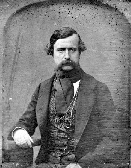
Richard Blanshard MA was an English barrister and first governor of the Colony of Vancouver Island from its foundation in 1849 to his resignation in 1851.

Garibaldi Provincial Park, also called Garibaldi Park, is a wilderness park located on the coastal mainland of British Columbia, Canada, 70 kilometres (43.5 mi) north of Vancouver. It was established in 1920 and named a Class A Provincial Park of British Columbia in 1927. The park is a popular destination for outdoor recreation, with over 30,000 overnight campers and over 106,000 day users in the 2017/2018 season.

The Bugaboos are a mountain range in the Purcell Mountains of eastern British Columbia, Canada. The granite spires of the group are a popular mountaineering destination. The Bugaboos are protected within Bugaboo Provincial Park.

Mount Burke, 1,270 m (4,167 ft), is a mountain located in northeast Coquitlam, British Columbia, north of Port Coquitlam on the ridge system leading to Coquitlam Mountain. Most of the mountain is part of Pinecone Burke Provincial Park. Mount Burke is found in Coquitlam near Minnekhada Regional Park.

The North Shore Mountains are a mountain range overlooking Vancouver in British Columbia, Canada. Their southernmost peaks are visible from most areas in Vancouver and form a distinctive backdrop for the city.

Pinecone Burke Provincial Park is a provincial park in British Columbia, Canada. It extends from the southwest corner of Garibaldi Provincial Park, west of Pitt Lake and Pitt River to include Burke Mountain in the City of Coquitlam. Most of the park is unserviced wilderness with very rough trails such as the Fools Gold Trail in the Boise Valley. There is canoe access to Widgeon Slough and from there hiking trails that lead to Widgeon Lake, and a network of old logging roads, hiking and mountain biking trails on Burke Mountain. Visitors can also use the park for camping, backcountry skiing, and snowshoeing.

Golden Ears Provincial Park is a 555.9 square kilometres (214.6 sq mi) provincial park in British Columbia, Canada. It is named after the prominent twin peaks, which are commonly referred to as Golden Ears. The park was originally part of Garibaldi Provincial Park but was split off as a separate park in 1967. The area was logged extensively in the 1920s by the Lougheed and Abernathy Logging Company. Many recreational attractions are found within the park. Golden Ears Provincial Park is a protected area that contains many endangered species of flora and fauna.

Mount Maxwell Provincial Park is a provincial park in the Gulf Islands of British Columbia, Canada. It is located on Burgoyne Bay and the Sansum Narrows on the western shores of Saltspring Island.

Strathcona Provincial Park is the oldest provincial park in British Columbia, Canada, and the largest on Vancouver Island. Founded in 1911, the park was named for Donald Alexander Smith, 1st Baron Strathcona and Mount Royal, a wealthy philanthropist and railway pioneer. It lies within the Strathcona Regional District. The Clayoquot Sound Biosphere Reserve, established in 2000, includes three watersheds in the western area of the park.
Mount Edziza, sometimes called Edziza Mountain or Edziza Peak, is a volcanic mountain in Cassiar Land District of northwestern British Columbia, Canada. It is located on the Big Raven Plateau of the Tahltan Highland which extends along the western side of the Stikine Plateau. Mount Edziza has an elevation of 2,786 metres and a topographic prominence of 1,750 metres, making it the highest point of the Mount Edziza volcanic complex and one of Canada's ultra-prominent peaks. However, it had an elevation of at least 3,396 metres before its formerly cone-shaped summit was likely destroyed by a violent, climactic eruption in the geologic past; its current flat summit contains an ice-filled, 2-kilometre-in diameter (1.2-mile) crater. The mountain contains several lava domes, cinder cones and lava fields on its flanks, as well as an ice cap that is characterized by several outlet glaciers stretching out to lower altitudes. All sides of Mount Edziza are drained by tributaries of Mess Creek and Kakiddi Creek which are situated within the Stikine River watershed.

Mount Judge Howay, originally the Snow Peaks, is a distinctive twin summit located 10 km (6 mi) from the Central Fraser Valley and, close up, the north end of Stave Lake. Being one of the highest peaks in the region, it is visible from many of the peaks around Vancouver, British Columbia. It is in the eastern part of Golden Ears Provincial Park. Mount Robie Reid is to the south.

Edge Peak is a summit in the Golden Ears Group, located in Golden Ears Provincial Park north of Maple Ridge, British Columbia. The peak is not named for its shape but rather for Sam Edge who climbed it in 1876. Other mountains in this area include Golden Ears and Blanshard Peak.

Blanshard Peak also known as The Blanshard Needle by local climbers is a distinctive rock pinnacle in Golden Ears Provincial Park that is visible from many places in the Lower Mainland. Named for the first governor of the colony of Vancouver Island, the name of the summit and area is the subject of some confusion due to the labeling of the entire Golden Ears Group on the published maps for the area. Mount Blanshard is the proper name of the Golden Ears massif, and later became attached by authors of climbing guides to the summit at the southern end of the group.

The Golden Ears is the name used by the Bivouac Mountain Encyclopedia for a group of mountains in the southern portion of Golden Ears Provincial Park, and visible to most of the Lower Mainland of British Columbia. It is a part of the Garibaldi Ranges, and is located in Golden Ears Provincial Park.
Eagle Mountain, also known as Eagle Ridge, is the mountainous ridge with many indistinct summits between Buntzen Lake and Coquitlam Lake near Coquitlam, British Columbia. Its proximity to Coquitlam, and the houses being built on its southern slopes, make it a very popular weekend destination for hiking, mountain biking, horseback riding, and ATV riding. There is a network of logging roads leading up the south side of the summit to a plateau area with lakes, hiking trails and mountain biking trails.

Mount Elsay is a mountain in southwestern British Columbia, Canada, located near the middle of Mount Seymour Provincial Park in the District of North Vancouver. It is a part of the North Shore Mountains, rising from the shores of Indian Arm to a summit of 1,419 m (4,656 ft). It is named after nearby Elsay Lake and Creek. These names are thought to derive from a Scottish settler, probably after a place name in Scotland.

Mount Robie Reid 2,095 m (6,873 ft) is a mountain in the eastern part of Golden Ears Provincial Park in the southern end of the Garibaldi Ranges overlooking the Lower Mainland region of British Columbia, Canada. It lies to the north of Mission, British Columbia and on the west side of the upper end of Stave Lake, and to the northeast of the group of summits known as the Golden Ears. Mount Judge Howay is to the north. Robie Reid has a prominence of 1,245 m (4,085 ft) relative to the lowest col between the valleys of Tingle and Osprey Creeks.
Neal Marshall Carter was a Canadian marine biologist, cartographer, photographer, mountaineer and surveyor. He is most famous for his explorations in British Columbia, especially in the Coast Mountains where he made several first ascents.


