Bonnie Doon is a neighbourhood in south-central Edmonton, Alberta, Canada. The well-known Mill Creek Ravine Park forms its west boundary. The Bonnie Doon shopping mall is on its east boundary.

Codornices Creek, 2.0 miles (3.2 km) long, is one of the principal creeks which runs out of the Berkeley Hills in the East Bay area of the San Francisco Bay Area in California. In its upper stretch, it passes entirely within the city limits of Berkeley, and marks the city limit with the adjacent city of Albany in its lower section. Before European settlement, Codornices probably had no direct, permanent connection to San Francisco Bay. Like many other small creeks, it filtered through what early maps show as grassland to a large, northward-running salt marsh and slough that also carried waters from Marin Creek and Schoolhouse Creek. A channel was cut through in the 19th century, and Codornices flows directly to San Francisco Bay by way of a narrow remnant slough adjacent to Golden Gate Fields racetrack.

Burnaby South Secondary is a public high school in Burnaby, British Columbia, and it serves the South Slope, Burnaby neighbourhood, and Southern Burnaby. It is one of the eight high schools within School District 41 Burnaby, and it currently contains approximately 1700 students.

Daylighting is the opening up and restoration of a previously buried watercourse, one which had at some point been diverted below ground. Typically, the rationale behind returning the riparian environment of a stream, wash, or river to a more natural above-ground state is to reduce runoff, create habitat for species in need of it, or improve an area's aesthetics. In the United Kingdom, the practice is also known as deculverting.

Pelmo Park-Humberlea is a neighbourhood in Toronto, Ontario, Canada. It is located north-west of the central core, in the former suburb of North York. Many of the neighbourhoods in this quadrant of the city can aptly be described as family neighbourhoods with access to parks, green space and a slower pace than found closer to downtown.
Parkwoods or sometimes referred to as Parkwoods-Donalda, is a neighbourhood in Toronto, Ontario, Canada. It is a geographically large neighbourhood located just south of Ontario Highway 401, west of Victoria Park Avenue, north of Lawrence Avenue East and east of the Don Valley Parkway.

Brentwood Park, or simply Brentwood, is a neighbourhood in North Burnaby, British Columbia, between Willingdon Avenue to the west and Springer Avenue to the east. Hastings Street separates it from the Capitol Hill area to the north, while Lougheed Highway marks the dividing line between this residential area and an area of commercial and industrial land to the south.
The Near East Side is a neighborhood located near downtown Columbus, Ohio, made up of several neighborhoods: Mount Vernon, King-Lincoln Bronzeville, Eastgate, Franklin Park, Nelson Park, Olde Towne East, and Woodland Park.
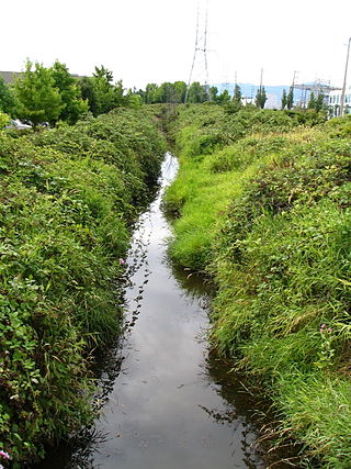
Still Creek is a long stream flowing across Central Burnaby, British Columbia and into Burnaby Lake. Still Creek's path lies mainly through the industrial area which contributes to its high level of pollution, although through dedicated work of local volunteers the creek is slowly recovering.

Eagle Creek is one of the most important creeks in Burnaby, British Columbia, Canada. It begins on Burnaby Mountain where it is fed by a large watershed, runs through Montecito and the nearby Squint Lake, and eventually flows into Burnaby Lake.
Columbus, the state capital and Ohio's largest city, has numerous neighborhoods within its city limits. Neighborhood names and boundaries are not officially defined. They may vary or change from time to time due to demographic and economic variables.
Avonmore is a residential neighbourhood in south east Edmonton, Alberta, Canada. It was named after Algernon William Yelverton, 6th Viscount Avonmore, a priest from Ireland. It is in the shape of an irregular quadrilateral bounded on the south east by Argyll Road, on the south west by Mill Creek Ravine, on the north by 76 Avenue and on the east by 75 Street. It is surrounded by a mixture of residential neighbourhoods and industrial subdivisions. To the north is the residential subdivision of King Edward Park. To the east and south east are the industrial subdivisions of Girard Industrial and Coronet Addition Industrial. Separated from Avonmore by the Mill Creek Ravine are the residential neighbourhoods of Argyll, Hazeldean and Ritchie.
Lansdowne is a neighbourhood in south west Edmonton, Alberta, Canada overlooking the Whitemud Creek Ravine. The Snow Valley Ski Hill is located near the neighbourhood. The neighbourhood is situated directly across from Michener Park, a residential complex for students staying at the University of Alberta.
The city of Sault Ste. Marie, Ontario, Canada contains a significant number of named residential neighbourhoods, including Bayview, Broadview Gardens, Brookfield, Buckley, Carpin Beach, Cedar Heights, East Korah, Eastside, Fort Creek, Grandview Gardens, Korah, Manitou Park, McQueen, Meadow Park, Nokomis Beach, Odena, The P Patch, Pointe aux Pins, Pointe des Chênes, Pointe Louise and Steelton.

Trinity-Bellwoods is an inner city neighbourhood in Toronto, Ontario, Canada. It is bounded on the east by Bathurst Street, on the north by College Street, on the south by Queen Street West, and by Dovercourt Road on the west. It has a large Portuguese and Brazilian community, and many local Portuguese-Canadian businesses are located along Dundas Street West, continuing west into Little Portugal; this stretch further west along Dundas is known as Rua Açores.
Maywood is a mainly-rental low-income residential neighborhood in Burnaby, and is a part of the larger Metrotown area. The neighborhood consists of low-rise apartments built during the population boom in the Metrotown area in the 1970s, and 1980s, although the neighborhood is quickly changing with numerous highrises. Geographically, the Maywood neighbourhood's boundaries are Grange Street and Kingsway to the north, Nelson Avenue and Bennett and Bonsor Streets to the east, Imperial Street to the south and Boundary Road to the west, and it includes Central Park.

Big Bend is the southernmost neighbourhood in Burnaby, British Columbia, Canada, located on the watershed of the Fraser River. The neighbourhood owes its name to the large bend that the river forms on its North Arm. Big Bend comprises all of Burnaby south of Marine Drive.

Marlborough is a neighbourhood in Burnaby, British Columbia, Canada, located on the southern part of Burnaby. The neighbourhood is bounded by Dover Street, Royal Oak Avenue to the east, Kingsway to the south and Nelson Avenue to the west. It is from walking to Metropolis at Metrotown, making it an attractive area.
