
The Tasmanian Legislative Council is the upper house of the Parliament of Tasmania in Australia. It is one of the two chambers of the Parliament, the other being the House of Assembly. Both houses sit in Parliament House in the state capital, Hobart. Members of the Legislative Council are often referred to as MLCs.

The Division of Franklin is an Australian electoral division in Tasmania.

The electoral division of Windermere is one of the 15 electorates or 'seats' in the Tasmanian Legislative Council. The division is located on the East side of the Tamar River. It is named after the town of Windermere which is located along the banks of the river between Launceston and George Town.

The electoral division of Apsley was an electorate of the Tasmanian Legislative Council, it was created in 1999 and abolished in 2017.

The electoral division of Franklin is one of the five electorates in the Tasmanian House of Assembly, located in southern Tasmania and includes Bruny Island, Kingston and the eastern shore of the Derwent River. Franklin is named after Sir John Franklin, the Arctic explorer who was Lieutenant-Governor of Van Diemen's Land (1837–43). The division shares its name and boundaries with the federal division of Franklin.

The electoral division of Pembroke is one of the 15 electorates or 'seats' in the Tasmanian Legislative Council or upper house. It is located on Hobart's Eastern Shore and includes a number of suburbs; Risdon Vale, Geilston Bay, Rose Bay, Lindisfarne, Warrane, Mornington, Bellerive, Howrah and Tranmere. In earlier times, the division included most of the east coast of Tasmania as far north as Bicheno, including the Tasman Peninsula.

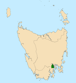
The electoral division of Rumney is one of the 15 electoral divisions in the Tasmanian Legislative Council. The division is located in Southern Tasmania to the east of the division of Pembroke.

The electoral division of Nelson is a constituency of the Tasmanian Legislative Council. The division includes many of the suburbs to the south of Hobart, including South Hobart, Sandy Bay, Taroona and Kingston. The division was created in 1999 when the electoral division of Queenborough was renamed in a review of electoral boundaries. The member from 1999 until his retirement in 2019 was independent Jim Wilkinson.

The electoral division of Murchison is one of the fifteen electorates in the Tasmanian Legislative Council, situated in the western/north-west region of the state. It is the largest electorate in size, covering an area of 19,391 km² and includes the municipalities of Circular Head, King Island, Waratah-Wynyard, West Coast and part of Burnie City.

The Electoral division of Huon is one of the 15 electoral divisions in the Tasmanian Legislative Council. It was created in 1999, however similar electorates of this name have existed since 1900, and members of the Tasmanian upper house for this region appear to have been elected since 1856.

The electoral division of Mersey is one of the fifteen constituencies in the Tasmanian Legislative Council. The division covers an area of 732 km2.

The electoral division of Montgomery is one of the fifteen electorates in the Tasmanian Legislative Council.

The electoral division of Launceston is one of 15 electorates or seats in the Tasmanian Legislative Council, created in 2008. It also previously existed until 1999, when it was abolished and substantially incorporated into the new division of Paterson, which was in turn abolished in 2008.

The electoral division of Elwick is one of the 15 electoral divisions in the Tasmanian Legislative Council. The division covers most of the municipality of Glenorchy.

The electoral division of Hobart is one of the 15 electoral divisions in the Tasmanian Legislative Council. It was originally created in 1856 when the Council became the upper house of the Parliament of Tasmania. The seat was abolished in 1999 and re-created in 2008 after a redistribution saw the former division of Wellington returned to its former name.
The electoral division of Western Tiers was an electorate of the Tasmanian Legislative Council, the division was abolished in 2017. The seat was created in 2008 after a redistribution saw the former Rowallan renamed after the Great Western Tiers mountain range in Tasmania's central highlands.

The electoral division of McIntyre is one of the fifteen electorates in the Tasmanian Legislative Council, it includes Flinders Island, the northern east coast of Tasmania, and regional areas south and west of Launceston. It is named after Margaret McIntyre, who was the first woman to be elected into the Parliament of Tasmania in 1948.

The electoral division of Prosser is one of the fifteen electorates in the Tasmanian Legislative Council, it includes the south-east coast of Tasmania, the Sorell township and the Tasman Peninsula. Prosser is named after the Prosser River, which flows through the centre of the division.

The Division of Clark is an Australian Electoral Division in the state of Tasmania, first contested at the 2019 federal election.
The electoral division of Clark is one of the five electorates in the Tasmanian House of Assembly, it is located in Hobart on the western shore of the River Derwent and includes the suburbs below Mount Wellington. Clark is named after Andrew Inglis Clark, a Tasmanian jurist who was the principal author of the Australian Constitution. The electorate shares its name and boundaries with the federal division of Clark.

