Electoral division of Windermere

Last updated

Windermere
TasmaniaLegislative Council
Electoral division of Windermere

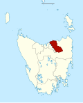
Map showing the electoral division of Windermere, as of the 2017 periodic review. [1]

Contents

State Tasmania
Created1999
MP Nick Duigan
Party Liberal
Electors 27,342 (2021)
Area2,047 km2 (790.4 sq mi)
DemographicRural
Coordinates 41°16′30″S147°12′58″E / 41.275°S 147.216°E / -41.275; 147.216
Locator map of Windermere TLC electorate 2017.svg

The electoral division of Windermere is one of the 15 electorates or 'seats' in the Tasmanian Legislative Council. The division is located on the East side of the Tamar River. It is named after the town of Windermere which is located along the banks of the river between Launceston and George Town.

Within the electorate are the towns of George Town, Low Head, Windermere, Dilston, Relbia, Hillwood and Bell Bay. The Launceston suburbs of Rocherlea, Newnham, Mowbray, Mayfield, Ravenswood, St Leonards, Elphin and Waverley.

The voting population in keeping with other divisional boundaries is approximately 26,000 voters. The current sitting member is Liberal Nick Duigan. The boundaries of Windermere were determined by a redistribution which occurred in 2017.

Members

MemberPartyPeriod
  Silvia Smith Independent 1999–2003
  Ivan Dean Independent 2003–2021
  Nick Duigan Liberal 2021–present

See also

Related Research Articles

<span class="mw-page-title-main">Tasmanian House of Assembly</span> Lower house of the Parliament of Tasmania

The House of Assembly, or Lower House, is one of the two chambers of the Parliament of Tasmania in Australia. The other is the Legislative Council or Upper House. It sits in Parliament House in the state capital, Hobart.

<span class="mw-page-title-main">Tasmanian Legislative Council</span> Upper house of the Parliament of Tasmania

The Tasmanian Legislative Council is the upper house of the Parliament of Tasmania in Australia. It is one of the two chambers of the Parliament, the other being the House of Assembly. Both houses sit in Parliament House in the state capital, Hobart. Members of the Legislative Council are often referred to as MLCs.

<span class="mw-page-title-main">Electoral division of Rosevears</span> Tasmanian Legislative Council electoral division

The electoral division of Rosevears is one of the 15 electorates or 'seats' in the Tasmanian upper house. The division is located on the west side of the Tamar River. It is named after the town of Rosevears which is located on the river banks near Exeter.

<span class="mw-page-title-main">Electoral division of Paterson</span>

The electoral division of Paterson was one of the 15 electorates or 'seats' in the Tasmanian Legislative Council from 1999 to 2008 when a redistribution saw it reverted to its original name of Launceston.

<span class="mw-page-title-main">Electoral division of Apsley</span> Forner Tasmanian Legislative Council electoral division

The electoral division of Apsley was an electorate of the Tasmanian Legislative Council, it was created in 1999 and abolished in 2017.

<span class="mw-page-title-main">Division of Franklin (state)</span> Tasmanian state electoral division

The electoral division of Franklin is one of the five electorates in the Tasmanian House of Assembly, located in southern Tasmania and includes Bruny Island, Kingston and the eastern shore of the Derwent River. Franklin is named after Sir John Franklin, the Arctic explorer who was Lieutenant-Governor of Van Diemen's Land (1837–43). The division shares its name and boundaries with the federal division of Franklin.

<span class="mw-page-title-main">Division of Bass (state)</span> State electoral division of Tasmania

The electoral division of Bass is one of the five electorates in the Tasmanian House of Assembly, it includes north-east Tasmania and Flinders Island. Bass takes its name from the British naval surgeon and explorer of Australia: George Bass. The division shares its name and boundaries with the federal division of Bass.

<span class="mw-page-title-main">Division of Braddon (state)</span> Tasmanian state electoral division

The electoral division of Braddon is one of the five electorates in the Tasmanian House of Assembly, it includes north-west and western Tasmania as well as King Island. Braddon takes its name from the former Premier of Tasmania, Sir Edward Braddon. The division shares its name and boundaries with the federal division of Braddon.

<span class="mw-page-title-main">Division of Lyons (state)</span> Tasmanian state electoral division

The electoral division of Lyons is one of the five electorates in the Tasmanian House of Assembly, it is the largest electorate covering most of central and eastern Tasmania. Lyons is named jointly in honour of Joseph Lyons, Prime Minister of Australia (1932–1939); Premier of Tasmania (1923–1928), and Joseph's wife, Dame Enid Lyons, the first woman elected to the Australian House of Representatives in 1943. The electorate shares its name and boundaries with the federal division of Lyons.

<span class="mw-page-title-main">Electoral division of Pembroke</span> Tasmanian Legislative Council electoral division

The electoral division of Pembroke is one of the 15 electorates or 'seats' in the Tasmanian Legislative Council or upper house. It is located on Hobart's Eastern Shore and includes a number of suburbs; Risdon Vale, Geilston Bay, Rose Bay, Lindisfarne, Warrane, Mornington, Bellerive, Howrah and Tranmere. In earlier times, the division included most of the east coast of Tasmania as far north as Bicheno, including the Tasman Peninsula.

<span class="mw-page-title-main">Electoral division of Rumney</span> Tasmanian Legislative Council electoral division

The electoral division of Rumney is one of the 15 electoral divisions in the Tasmanian Legislative Council. The division is located in Southern Tasmania to the east of the division of Pembroke.

<span class="mw-page-title-main">Electoral division of Derwent</span> Tasmanian Legislative Council electoral division

The electoral division of Derwent is one of the 15 electoral divisions in the Tasmanian Legislative Council. It is situated in the central south of the state.

<span class="mw-page-title-main">Electoral division of Murchison</span> Tasmanian Legislative Council electoral division

The electoral division of Murchison is one of the fifteen electorates in the Tasmanian Legislative Council, situated in the western/north-west region of the state. It is the largest electorate in size, covering an area of 19,391 km² and includes the municipalities of Circular Head, King Island, Waratah-Wynyard, West Coast and part of Burnie City.

<span class="mw-page-title-main">Electoral division of Mersey</span> Electoral division of the Tasmanian Legislative Council

The electoral division of Mersey is one of the fifteen constituencies in the Tasmanian Legislative Council. The division covers an area of 732 km2.

<span class="mw-page-title-main">Electoral division of Montgomery</span> Tasmanian Legislative Council electoral division

The electoral division of Montgomery is one of the fifteen electorates in the Tasmanian Legislative Council.

<span class="mw-page-title-main">Electoral division of Launceston</span> Electoral division of the Tasmanian Legislative Council

The electoral division of Launceston is one of 15 electorates or seats in the Tasmanian Legislative Council, created in 2008. It also previously existed until 1999, when it was abolished and substantially incorporated into the new division of Paterson, which was in turn abolished in 2008.

The electoral division of Cornwall was an electoral division in the Tasmanian Legislative Council of Australia. It was abolished in 1999 after the Legislative Council was reduced from 19 members to 15.

<span class="mw-page-title-main">Electoral division of McIntyre</span> Tasmanian Legislative Council electoral division

The electoral division of McIntyre is one of the fifteen electorates in the Tasmanian Legislative Council, it includes Flinders Island, the northern east coast of Tasmania, and regional areas south and west of Launceston. It is named after Margaret McIntyre, who was the first woman to be elected into the Parliament of Tasmania in 1948.

<span class="mw-page-title-main">Electoral division of Prosser</span> Tasmanian Legislative Council electoral division

The electoral division of Prosser is one of the fifteen electorates in the Tasmanian Legislative Council, it includes the south-east coast of Tasmania, the Sorell township and the Tasman Peninsula. Prosser is named after the Prosser River, which flows through the centre of the division.

<span class="mw-page-title-main">Division of Clark (state)</span> State electoral division of Tasmania, Australia

The electoral division of Clark is one of the five electorates in the Tasmanian House of Assembly, it is located in Hobart on the western shore of the River Derwent and includes the suburbs below Mount Wellington. Clark is named after Andrew Inglis Clark, a Tasmanian jurist who was the principal author of the Australian Constitution. The electorate shares its name and boundaries with the federal division of Clark.

References

  1. Legislative Council Divisions (2016-17 redistribution) from theLIST ©State of Tasmania (Creative Commons Attribution 3.0 Australia Licence).