Related Research Articles

The House of Assembly, or lower house; Is one of the two chambers of the Parliament of South Australia. The other is the Legislative Council. It sits in Parliament House in the state capital, Adelaide.
Since 1970, the South Australian House of Assembly — the lower house of the Parliament of South Australia — has consisted of 47 single-member electoral districts consisting of approximately the same number of enrolled voters. The district boundaries are regulated by the State Electoral Office, according to the requirements of the South Australian Constitution and are subject to mandatory redistributions by the South Australian Electoral Districts Boundaries Commission in order to respond to changing demographics.

Minlaton is a town in central Yorke Peninsula, South Australia. It is known as the "Barley capital of the world", due to the rich Barley production in the region.
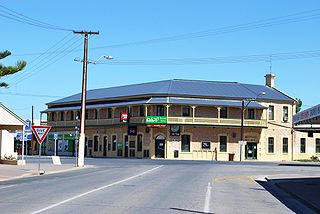
Yorketown is a town and a locality in the Australian state of South Australia located in the southern Yorke Peninsula about 91 kilometres (57 mi) west of the state capital of Adelaide and about 70 kilometres (43 mi) south of the municipal seat of Maitland.
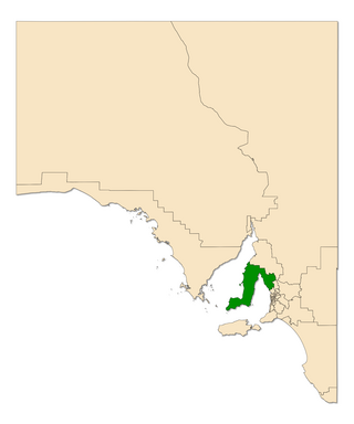
Goyder was an electoral district of the South Australian House of Assembly. It was a 9,258 km2 rural electorate located on the Yorke Peninsula and taking in the towns of Ardrossan, Bute, Edithburgh, Kadina, Maitland, Minlaton, Moonta, Port Wakefield, Wallaroo and Yorketown. The electorate was named after George Goyder, a former state Surveyor-General famous for developing Goyder's Line, which indicated the area of the state that had enough rainfall to be suitable for agriculture.

Kaurna is a single-member electoral district for the South Australian House of Assembly. Named after the Kaurna aboriginal tribe which originally inhabited the Adelaide plains, it is a 44.7 km² semi-urban electorate on Adelaide's far-southern beaches, taking in the suburbs of Hackham, Huntfield Heights, Maslin Beach, Moana, Noarlunga Downs, Old Noarlunga, Port Noarlunga South, Seaford, Seaford Heights, Seaford Meadows and Seaford Rise, as well as part of Onkaparinga Hills. It is one of two state districts named after South Australia's indigenous people.

Marion Bay is a small township in the Australian state of South Australia at the southern tip of the Yorke Peninsula.
Corny Point is a locality in the Australian state of South Australia located about 7.5 kilometres to the east of the north-western tip of the Yorke Peninsula. It was named after the nearby headland, Corny Point. The first pastoral lease was taken up in 1846 by James Coutts.
Sultana Point is a locality in the Australian state of South Australia located on the Yorke Peninsula immediately adjoining the western head of Gulf St Vincent about 80 kilometres west of the state capital of Adelaide.
Agery is a locality in the Australian state of South Australia located on Yorke Peninsula. It is situated 17 km south-east of Moonta. Its name comes from the Aboriginal word ngadjali meaning "pipe clay".

South Kilkerran is a locality in the Australian state of South Australia located on Yorke Peninsula between Maitland and Port Victoria.
Kainton is a small town in the Australian state of South Australia situated about 10 km south of Paskeville in the upper Yorke Peninsula.
Winulta was a town in the Australian state of South Australia on northern Yorke Peninsula around 10 km from Clinton on the Clinton-Maitland road. It was first settled for farming around 1876. The earliest farmers were William Short, Thomas Kenny and John Sharrad.
Nalyappa is a locality in the Australian state of South Australia located on the west coast of Yorke Peninsula immediately adjoining Spencer Gulf about 128 kilometres north-west of the state capital of Adelaide.
Black Point is a locality in the Australian state of South Australia located on the east coast of Yorke Peninsula about 72 kilometres northwest of the state capital of Adelaide.

Narungga is a single-member electoral district for the South Australian House of Assembly. It was created by the redistribution of 2016, and was contested for the first time at the 2018 state election. It is named for the Narungga people who are the traditional owners of the lands in most of the electorate. It is one of two state districts named after South Australia's indigenous people.
South Hummocks is a locality in the Mid North of South Australia at the head of Gulf St Vincent adjacent to Yorke Peninsula on the southeastern slopes of the Hummock Range.
This is a list of members of the South Australian House of Assembly from 2018 to 2022, as elected at the 2018 state election and subsequent by-elections.
Wauraltee is a locality in the Australian state of South Australia located on the Yorke Peninsula about 102 kilometres (63 mi) west of the state capital of Adelaide and about 25 kilometres (16 mi) south-west of the municipal seat of Maitland.
Koolywurtie is a locality in the Australian state of South Australia located on the Yorke Peninsula about 93 kilometres (58 mi) west of the state capital of Adelaide and about 20 kilometres (12 mi) south of the municipal seat of Maitland.