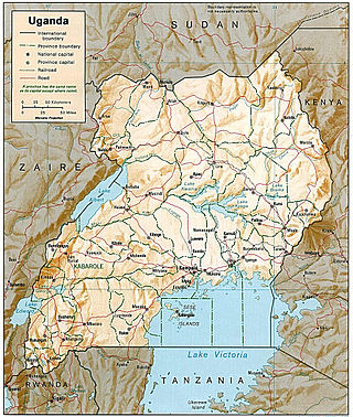
Transport in Uganda refers to the transportation structure in Uganda. The country has an extensive network of paved and unpaved roads.

Gulu is a district in the Northern Region of Uganda. The regional headquarters are located in the city of Gulu, which is also the administrative capital of Northern Uganda. the district consists of two main divisions, Gulu West and Gulu East.
Nimule is a city in the southern part of South Sudan in Magwi County, Eastern Equatoria. It lies approximately 197 kilometres (122 mi), by road, southeast of Juba, the capital of South Sudan and largest city in the country. The town also lies approximately 120 kilometres (75 mi), by road, north of Gulu, Uganda, the nearest large city.
Atiak is a town in the Northern Region of Uganda on the Gulu-Nimule Road, the primary trade route between Uganda and South Sudan.
Railway stations in Uganda include:

Busia is a town in the Eastern Region of Uganda. It is the main municipal, administrative, and commercial center of the Busia District, with the district headquarters located there.

Pabbo, sometimes spelled as Pabo, is a municipality in Amuru District of the Northern Region of Uganda.
Mutukula is a town in Kyotera District, in the Central Region of Uganda, the third-largest economy in the East African Community. It sits adjacent to Mutukula, Tanzania, directly across the international border between Uganda and Tanzania.
Gulu–Nimule Road is a road in the Northern Region of Uganda, connecting the city of Gulu in Gulu District and the town of Nimule in Eastern Equatoria State in South Sudan, just north of the international border between the two countries. The road, known as Highway A104 in Uganda, continues into South Sudan as Highway A43.
Bibia is a municipality in the Amuru District of the Northern Region of Uganda.
Amuru is a town in the Northern Region of Uganda. It is the main municipal, administrative, and commercial centre of Amuru District.
Rwekunye–Apac–Aduku–Lira–Kitgum–Musingo Road is a road in the Northern Region of Uganda, connecting the towns of Masindi Port in Kiryandongo District to Apac in Apac District, Lira in Lira District, Acholibur in Pader District, Kitgum in Kitgum District, and Musingo in Lamwo District at the international border with South Sudan.
The Atiak–Adjumani–Moyo–Afonji Road is in the Northern Region of Uganda, connecting the towns of Atiak, Adjumani, Moyo, and Afoji at the international border with South Sudan.
Omoro District is a district in the Northern Region of Uganda.
The Uganda Standard Gauge Railway is a planned railway system linking the country to the neighboring countries of Kenya, Rwanda, Democratic Republic of the Congo and South Sudan, as part of the East African Railway Master Plan. The new Standard Gauge Railway (SGR), is intended to replace the old, inefficient metre-gauge railway system. The entire 1,724 kilometres (1,071 mi) SGR in Uganda will cost an estimated $12.8 billion.
Mbalwa is a neighborhood in Kyaliwajjala Parish, Kira Municipality, Wakiso District in the Central Region of Uganda.
Kijabijo is a neighborhood in Kira Town, in Wakiso District in the Buganda Region of Uganda.
The Kampala–Gulu Highway, also Kampala–Gulu Road, is a road connecting the capital city of Kampala, in the Central Region, with the city of Gulu, the largest urban centre in the Northern Region of Uganda.
The Karuma–Juba High Voltage Power Line is a planned high voltage electricity power line, connecting the high voltage substation at Karuma, in Kiryandongo District, in the Western Region of Uganda, to another high voltage substation at Juba, in Jubek State, in South Sudan.


